

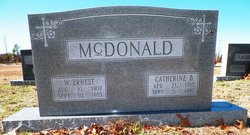
Edgar Benford “Benny” McDonald
| Birth | : | 5 Nov 1921 Richmond County, North Carolina, USA |
| Death | : | 23 Mar 1998 Long Beach, Brunswick County, North Carolina, USA |
| Burial | : | Sunset Cemetery, Prairie Farm, Barron County, USA |
| Coordinate | : | 45.2538986, -92.0002975 |
| Description | : | News & Observer, The (Raleigh, NC) - March 24, 1998 -------------------------------------------------------------------------------- Deceased Name: EDGAR "BENNY" McDONALD LONG BEACH - Mr. Edgar Benford "Benny" McDonald, 76 of 108 N.E. 41st St., Long Beach died Mon. March 23, 1998 at his residence. Funeral service will be conducted at 10 a.m. Wed. at First Baptist Church of Oak Island, where he was a member, with Dr. William B. Hutchinson officiating. Graveside service will be conducted at 4 p.m. Wed. in the McDonald Baptist Church Cemetery, Rockingham with Masonic rites accorded by Oak Island Masonic Lodge #758. Serving as pallbearerswill be members of the Oak Island Masonic... Read More |
frequently asked questions (FAQ):
-
Where is Edgar Benford “Benny” McDonald's memorial?
Edgar Benford “Benny” McDonald's memorial is located at: Sunset Cemetery, Prairie Farm, Barron County, USA.
-
When did Edgar Benford “Benny” McDonald death?
Edgar Benford “Benny” McDonald death on 23 Mar 1998 in Long Beach, Brunswick County, North Carolina, USA
-
Where are the coordinates of the Edgar Benford “Benny” McDonald's memorial?
Latitude: 45.2538986
Longitude: -92.0002975
Family Members:
Parent
Spouse
Siblings
Flowers:


Nearby Cemetories:
1. Sunset Cemetery
Prairie Farm, Barron County, USA
Coordinate: 45.2538986, -92.0002975
2. Akers Cemetery
Prairie Farm, Barron County, USA
Coordinate: 45.2372017, -92.0141983
3. Evergreen Cemetery
Prairie Farm, Barron County, USA
Coordinate: 45.2477989, -91.9736023
4. Solum Cemetery
Prairie Farm, Barron County, USA
Coordinate: 45.2266998, -92.0136032
5. Vanceburg Cemetery
Dunn County, USA
Coordinate: 45.1899986, -91.9957962
6. Saint Pauls Evangelical Lutheran Cemetery
Prairie Farm, Barron County, USA
Coordinate: 45.2089100, -91.9325420
7. Mount Hope Cemetery
Arland, Barron County, USA
Coordinate: 45.3083800, -92.0570400
8. West Akers Lutheran Church Cemetery
Ridgeland, Dunn County, USA
Coordinate: 45.2041100, -92.0689300
9. Glenwood Cemetery
Dallas, Barron County, USA
Coordinate: 45.2827988, -91.9103012
10. Independent Cemetery
Arland, Barron County, USA
Coordinate: 45.3232994, -92.0132980
11. Oak Grove Cemetery
Ridgeland, Dunn County, USA
Coordinate: 45.1931000, -91.9266968
12. Saint John's Cemetery
Reeve, Barron County, USA
Coordinate: 45.2818985, -92.1108017
13. Reeve Cemetery
Reeve, Barron County, USA
Coordinate: 45.2382230, -92.1164770
14. Saint Charles Cemetery
Arland, Barron County, USA
Coordinate: 45.3102989, -92.0935974
15. Holy Trinity Orthodox Cemetery
Reeve, Barron County, USA
Coordinate: 45.2851330, -92.1357110
16. Greenwood Cemetery
Dallas, Barron County, USA
Coordinate: 45.2234180, -91.8605410
17. Saint Pauls Evangelical Lutheran Cemetery
Dallas, Barron County, USA
Coordinate: 45.2908300, -91.8595220
18. Old Hillsdale Cemetery
Hillsdale, Barron County, USA
Coordinate: 45.3142014, -91.8694000
19. Graytown Cemetery
Connorsville, Dunn County, USA
Coordinate: 45.2088000, -92.1441900
20. Bethany Lutheran Church Cemetery
Turtle Lake, Barron County, USA
Coordinate: 45.3587800, -92.0536900
21. Sheridan Zion Cemetery
Ridgeland, Dunn County, USA
Coordinate: 45.1502500, -91.9419000
22. New Haven Cemetery
Connorsville, Dunn County, USA
Coordinate: 45.1507988, -92.0671997
23. Moon Lake Cemetery
Turtle Lake, Barron County, USA
Coordinate: 45.3417015, -92.1055984
24. Dallas Cemetery
Dallas, Barron County, USA
Coordinate: 45.2728004, -91.8225021