
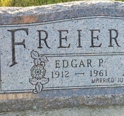

Edgar Phillip Freier
| Birth | : | 3 May 1912 Hutchinson County, South Dakota, USA |
| Death | : | Jul 1961 |
| Burial | : | Friedens Reformed Cemetery, Tripp, Hutchinson County, USA |
| Coordinate | : | 43.2113991, -97.9657974 |
| Description | : | Married Irene Meta Dewald in Hutchinson County, South Dakota on June 17, 1945 Name: Edgar Freier Gender: Male Death Age: 49 Birth Date: 4 May 1912 Birth Place: Delmont Marriage Date: 17 Jun 1945 Residence Place: Tripp Death Date: Abt 1961 Obituary Date: 19 Jul 1961 Obituary Place: Sioux City, Iowa, United States of America Spouse: Irene Dewald Child: Elwyn Siblings: J Sayler Dewald Winter Taken from Ancestry.com |
frequently asked questions (FAQ):
-
Where is Edgar Phillip Freier's memorial?
Edgar Phillip Freier's memorial is located at: Friedens Reformed Cemetery, Tripp, Hutchinson County, USA.
-
When did Edgar Phillip Freier death?
Edgar Phillip Freier death on Jul 1961 in
-
Where are the coordinates of the Edgar Phillip Freier's memorial?
Latitude: 43.2113991
Longitude: -97.9657974
Family Members:
Spouse
Flowers:


Nearby Cemetories:
1. Friedens Reformed Cemetery
Tripp, Hutchinson County, USA
Coordinate: 43.2113991, -97.9657974
2. Grace Hill Cemetery
Tripp, Hutchinson County, USA
Coordinate: 43.2111015, -97.9638977
3. Cathedral Catholic Cemetery
Tripp, Hutchinson County, USA
Coordinate: 43.2121100, -97.9619600
4. Zion Lutheran Cemetery
Tripp, Hutchinson County, USA
Coordinate: 43.1974400, -97.9917300
5. Haffner Family Farm Cemetery
Hutchinson County, USA
Coordinate: 43.2134840, -98.0312720
6. Pietz Cemetery
Hutchinson County, USA
Coordinate: 43.2703018, -97.9599991
7. Postahl Lutheran Cemetery
Kaylor, Hutchinson County, USA
Coordinate: 43.1834710, -97.8880710
8. Nagel Family Cemetery
Avon, Bon Homme County, USA
Coordinate: 43.1558851, -98.0101013
9. Oak Hollow Cemetery
Hutchinson County, USA
Coordinate: 43.1963997, -98.0599976
10. Dennewitz Cemetery
Hutchinson County, USA
Coordinate: 43.2400017, -97.8735962
11. Immanuel Reformed Church Cemetery
Bon Homme County, USA
Coordinate: 43.1250000, -97.9392014
12. Bethel Reformed Cemetery #1
Hutchinson County, USA
Coordinate: 43.2840710, -97.8878830
13. Emil G. Mogck Farm Cemetery
Hutchinson County, USA
Coordinate: 43.2308210, -97.8326250
14. Saints Cyril and Methodius Cemetery
Scotland, Bon Homme County, USA
Coordinate: 43.1305560, -97.8819440
15. Hoffnungsberg Cemetery
Hutchinson County, USA
Coordinate: 43.2972600, -98.0485700
16. Lake Baptist Cemetery
Hutchinson County, USA
Coordinate: 43.3106003, -97.9147034
17. Saint Johns Lutheran Cemetery
Kaylor, Hutchinson County, USA
Coordinate: 43.1763992, -97.8274994
18. Hoffnungstahl Cemetery
Kaylor, Hutchinson County, USA
Coordinate: 43.2708015, -97.8367004
19. Christina Koth Gravesite
Parkston, Hutchinson County, USA
Coordinate: 43.3203870, -97.9154910
20. Simental Cemetery
Hutchinson County, USA
Coordinate: 43.2132988, -97.8052979
21. New Salem Reformed Cemetery
Charles Mix County, USA
Coordinate: 43.1683006, -98.1271973
22. Bethel Reformed Cemetery #2
Hutchinson County, USA
Coordinate: 43.2967900, -97.8348800
23. Rosenfeld Cemetery
Hutchinson County, USA
Coordinate: 43.3381004, -97.9344025
24. Wittmeier Cemetery
Scotland, Bon Homme County, USA
Coordinate: 43.0825000, -97.9186900