
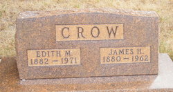
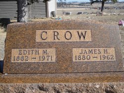
Edith Mae Clow Crow
| Birth | : | 12 Sep 1882 Nebraska, USA |
| Death | : | 2 Nov 1971 Billings, Yellowstone County, Montana, USA |
| Burial | : | Lodge Grass Cemetery, Lodge Grass, Big Horn County, USA |
| Coordinate | : | 45.3223340, -107.3785110 |
| Description | : | Edith and James were married in Bedford,Thomas County,Nebraska 9-17-1899. Edith was the daughter of James H and Rosabelle Bookneau Clow |
frequently asked questions (FAQ):
-
Where is Edith Mae Clow Crow's memorial?
Edith Mae Clow Crow's memorial is located at: Lodge Grass Cemetery, Lodge Grass, Big Horn County, USA.
-
When did Edith Mae Clow Crow death?
Edith Mae Clow Crow death on 2 Nov 1971 in Billings, Yellowstone County, Montana, USA
-
Where are the coordinates of the Edith Mae Clow Crow's memorial?
Latitude: 45.3223340
Longitude: -107.3785110
Family Members:
Spouse
Children

Flowers:


Nearby Cemetories:
1. Lodge Grass Cemetery
Lodge Grass, Big Horn County, USA
Coordinate: 45.3223340, -107.3785110
2. Forty Mile Colony Cemetery
Big Horn County, USA
Coordinate: 45.2856738, -107.3520215
3. Brightwing Cemetery
Big Horn County, USA
Coordinate: 45.1199989, -107.4383011
4. Garryowen Cemetery
Crow Agency, Big Horn County, USA
Coordinate: 45.5295868, -107.4309464
5. Little Bighorn Battlefield National Monument
Little Big Horn Battle Site, Big Horn County, USA
Coordinate: 45.5703000, -107.4273500
6. Custer National Cemetery
Crow Agency, Big Horn County, USA
Coordinate: 45.5699000, -107.4318000
7. Saint Xavier Catholic Mission Cemetery
Big Horn County, USA
Coordinate: 45.4636002, -107.7303009
8. Crow Agency Cemetery
Crow Agency, Big Horn County, USA
Coordinate: 45.6044006, -107.4730988
9. Apsaalooke Veterans Cemetery
Crow Agency, Big Horn County, USA
Coordinate: 45.6055500, -107.4776900
10. Two Moons Gravesite
Busby, Big Horn County, USA
Coordinate: 45.5308840, -106.9564430
11. Busby Cemetery
Busby, Big Horn County, USA
Coordinate: 45.5358009, -106.9505997
12. Fort Smith Cemetery
Fort Smith, Big Horn County, USA
Coordinate: 45.3120003, -107.9359970
13. Fairview Cemetery
Hardin, Big Horn County, USA
Coordinate: 45.7394981, -107.6415024
14. Dayton Cemetery
Dayton, Sheridan County, USA
Coordinate: 44.8724500, -107.2670500
15. Evangelical Lutheran Cemetery of Monarch
Monarch, Sheridan County, USA
Coordinate: 44.9073000, -107.0299000
16. Monarch Cemetery
Sheridan County, USA
Coordinate: 44.8969002, -107.0128021
17. Claussen Cemetery
Sheridan County, USA
Coordinate: 44.8225650, -107.2174870
18. Muddy Creek Cemetery
Muddy, Big Horn County, USA
Coordinate: 45.5741997, -106.7406006
19. Birney Cemetery
Rosebud County, USA
Coordinate: 45.2846985, -106.5868988
20. Fort Mackenzie Post Cemetery (Defunct)
Sheridan, Sheridan County, USA
Coordinate: 44.8311270, -106.9902060
21. Lame Deer Cemetery
Lame Deer, Rosebud County, USA
Coordinate: 45.6264000, -106.6619034
22. Trinity Lutheran Church Columbarium
Sheridan, Sheridan County, USA
Coordinate: 44.7995000, -106.9739000
23. Saint Peter's Episcopal Church Columbarium
Sheridan, Sheridan County, USA
Coordinate: 44.7971000, -106.9583000
24. Sheridan Municipal Cemetery
Sheridan, Sheridan County, USA
Coordinate: 44.7853012, -106.9702988