
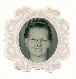
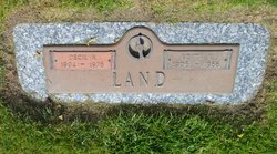
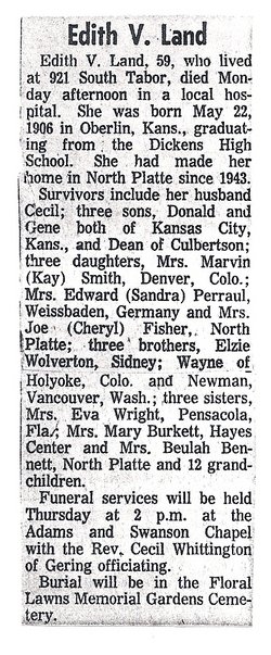
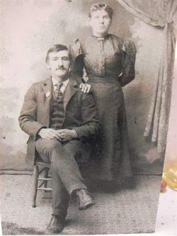
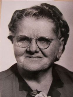
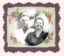
Edith Viola Wolverton Land
| Birth | : | 22 May 1906 Oberlin, Decatur County, Kansas, USA |
| Death | : | 24 Jan 1966 North Platte, Lincoln County, Nebraska, USA |
| Burial | : | Mile Creek Baptist Church Cemetery, Six Mile, Pickens County, USA |
| Coordinate | : | 34.8685989, -82.8469009 |
frequently asked questions (FAQ):
-
Where is Edith Viola Wolverton Land's memorial?
Edith Viola Wolverton Land's memorial is located at: Mile Creek Baptist Church Cemetery, Six Mile, Pickens County, USA.
-
When did Edith Viola Wolverton Land death?
Edith Viola Wolverton Land death on 24 Jan 1966 in North Platte, Lincoln County, Nebraska, USA
-
Where are the coordinates of the Edith Viola Wolverton Land's memorial?
Latitude: 34.8685989
Longitude: -82.8469009
Family Members:
Parent
Spouse
Siblings

Children
Flowers:


Nearby Cemetories:
1. Mile Creek Baptist Church Cemetery
Six Mile, Pickens County, USA
Coordinate: 34.8685989, -82.8469009
2. Crow Creek Church of God Cemetery
Six Mile, Pickens County, USA
Coordinate: 34.8689700, -82.8392900
3. Newton Family Cemetery
Six Mile, Pickens County, USA
Coordinate: 34.8667170, -82.8365170
4. Rhonda Thigpen Gravesite
Six Mile, Pickens County, USA
Coordinate: 34.8575190, -82.8226080
5. Keowee Baptist Church Cemetery
Six Mile, Pickens County, USA
Coordinate: 34.8613830, -82.8759000
6. Ellenburg-Holden Family Cemetery
Nine Times, Pickens County, USA
Coordinate: 34.8904260, -82.8667350
7. Stephens Family Cemetery
Pickens, Pickens County, USA
Coordinate: 34.8521060, -82.8735060
8. Alexander Family Cemetery
Pickens County, USA
Coordinate: 34.8989830, -82.8588670
9. Mountain View Baptist Church Cemetery
Six Mile, Pickens County, USA
Coordinate: 34.8577995, -82.8080978
10. Stewart Family Cemetery
Six Mile, Pickens County, USA
Coordinate: 34.9013700, -82.8326300
11. Rice-Spearman Family Cemetery
Sunset, Pickens County, USA
Coordinate: 34.9053500, -82.8307160
12. Pine Grove Baptist Church Cemetery
Sunset, Pickens County, USA
Coordinate: 34.8950170, -82.8836670
13. Gap Hill Baptist Church Cemetery
Six Mile, Pickens County, USA
Coordinate: 34.8293991, -82.8613968
14. Rackley Family Cemetery
Sunset, Pickens County, USA
Coordinate: 34.8938830, -82.8866160
15. Cedar Hill Holiness Church Cemetery
Six Mile, Pickens County, USA
Coordinate: 34.8324530, -82.8202970
16. Shady Grove Baptist Church Cemetery
Sunset, Pickens County, USA
Coordinate: 34.9150009, -82.8439026
17. Daniel Alexander Family Cemetery
Sunset, Pickens County, USA
Coordinate: 34.9170670, -82.8339830
18. Martin Grove Wesleyan Church Cemetery
Pickens, Pickens County, USA
Coordinate: 34.9068985, -82.8013992
19. Bolding-Garrett Cemetery
Six Mile, Pickens County, USA
Coordinate: 34.8400330, -82.7845830
20. New Hope Methodist Church Cemetery
Eastatoe, Pickens County, USA
Coordinate: 34.9264500, -82.8330330
21. Isaqueena Church of God Cemetery
Oconee County, USA
Coordinate: 34.8645160, -82.9189680
22. Mount Olivet Wesleyan Church Cemetery
Six Mile, Pickens County, USA
Coordinate: 34.8121430, -82.8242680
23. Mount Bethel United Methodist Church Cemetery
Sunset, Pickens County, USA
Coordinate: 34.9132996, -82.7968979
24. Bethel Church Cemetery
Sunset, Pickens County, USA
Coordinate: 34.9140010, -82.8962510