
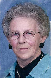
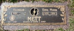
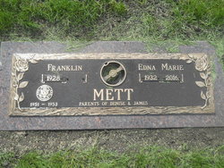
Edna Marie Westergard Mett
| Birth | : | 5 Feb 1932 Graettinger, Palo Alto County, Iowa, USA |
| Death | : | 30 Mar 2016 Spirit Lake, Dickinson County, Iowa, USA |
| Burial | : | North Lawn Cemetery, Spencer, Clay County, USA |
| Coordinate | : | 43.1600000, -95.1470000 |
| Description | : | Edna Marie Mett, the daughter of John and Venita (Hansen) Westergard, was born on February 5, 1932, in Graettinger, IA. She was raised and attended country schools near Graettinger and graduating from Ruthven High School. After high school she moved to Spencer, where she worked for the telephone company. On March 4, 1955, Edna married Franklin Mett at the Little Brown Church in Nashua, IA. Following their marriage, they lived on a farm southwest of Milford and then moved to Hartley. Edna was a homemaker and helped on the farm. She loved to cook and make big meals, she enjoyed tending... Read More |
frequently asked questions (FAQ):
-
Where is Edna Marie Westergard Mett's memorial?
Edna Marie Westergard Mett's memorial is located at: North Lawn Cemetery, Spencer, Clay County, USA.
-
When did Edna Marie Westergard Mett death?
Edna Marie Westergard Mett death on 30 Mar 2016 in Spirit Lake, Dickinson County, Iowa, USA
-
Where are the coordinates of the Edna Marie Westergard Mett's memorial?
Latitude: 43.1600000
Longitude: -95.1470000
Family Members:
Parent

Siblings
Flowers:


Nearby Cemetories:
1. North Lawn Cemetery
Spencer, Clay County, USA
Coordinate: 43.1600000, -95.1470000
2. Dewey Readmore Books Memorial
Spencer, Clay County, USA
Coordinate: 43.1403999, -95.1443024
3. Riverside Cemetery
Spencer, Clay County, USA
Coordinate: 43.1441994, -95.1671982
4. Fairview Cemetery
Clay County, USA
Coordinate: 43.1899986, -95.0800018
5. Evergreen Cemetery
Clay County, USA
Coordinate: 43.2052994, -95.2086029
6. Dickens Cemetery
Dickens, Clay County, USA
Coordinate: 43.1280000, -95.0155000
7. Swedish Lutheran Cemetery
Royal, Clay County, USA
Coordinate: 43.0683000, -95.2350000
8. Little Sioux Lutheran Cemetery
Milford, Dickinson County, USA
Coordinate: 43.2702065, -95.2109528
9. Rosehill Cemetery
Clay County, USA
Coordinate: 43.0368996, -95.0919037
10. First Reformed Cemetery
Clay County, USA
Coordinate: 43.2399500, -95.2889000
11. Lone Tree Cemetery
Everly, Clay County, USA
Coordinate: 43.1411018, -95.3347015
12. Milford Cemetery
Milford, Dickinson County, USA
Coordinate: 43.3092003, -95.1481018
13. Lincoln Cemetery
Rossie, Clay County, USA
Coordinate: 43.0111008, -95.2313995
14. Calvary Cemetery
Milford, Dickinson County, USA
Coordinate: 43.3213997, -95.1688995
15. Logan Township Cemetery
Clay County, USA
Coordinate: 43.0489006, -94.9747009
16. Liberty Cemetery
Greenville, Clay County, USA
Coordinate: 42.9897003, -95.1417007
17. Willow Creek Cemetery
Royal, Clay County, USA
Coordinate: 43.0214005, -95.2885971
18. Clay Center Cemetery
Royal, Clay County, USA
Coordinate: 43.0410995, -95.3272018
19. TriMello Cemetery
Royal, Clay County, USA
Coordinate: 43.0682983, -95.3728027
20. Crown Hill Cemetery
Ruthven, Palo Alto County, USA
Coordinate: 43.1328011, -94.8878021
21. Calvary Cemetery
Ruthven, Palo Alto County, USA
Coordinate: 43.1314011, -94.8869019
22. Zion Methodist Cemetery
Clay County, USA
Coordinate: 42.9808006, -95.2497025
23. Westport Cemetery
Dickinson County, USA
Coordinate: 43.3130989, -95.3289032
24. Okoboji Cemetery
Arnolds Park, Dickinson County, USA
Coordinate: 43.3649406, -95.1303558