
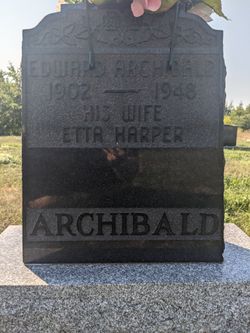
Edward Donald Archibald
| Birth | : | 21 Mar 1902 Belledune, Restigouche County, New Brunswick, Canada |
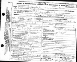
| Death | : | 11 Oct 1948 Durham Centre, Restigouche County, New Brunswick, Canada |
| Burial | : | St Luke's United Cemetery, Belledune, Gloucester County, Canada |
| Coordinate | : | 47.8871900, -65.8130800 |
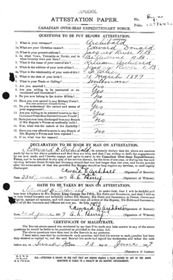
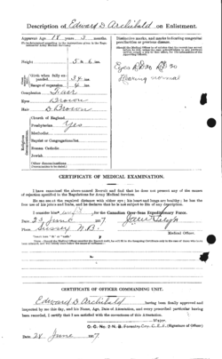
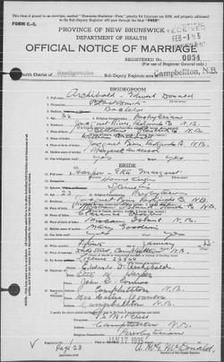
| Description | : | He enlisted in the Military on June 23rd 1917. He was 15 years old. On his attestation papers he was born on March 21st 1899, which would make him 18 years old. He lies about his age to fight in the war. Also according to his attestation papers, he was 5ft 6in, brown hair and brown eyes. He was also a milkman by trade. On January 15th 1935, he married Etta Margaret Harper in Campbellton, New Brunswick. |
frequently asked questions (FAQ):
-
Where is Edward Donald Archibald's memorial?
Edward Donald Archibald's memorial is located at: St Luke's United Cemetery, Belledune, Gloucester County, Canada.
-
When did Edward Donald Archibald death?
Edward Donald Archibald death on 11 Oct 1948 in Durham Centre, Restigouche County, New Brunswick, Canada
-
Where are the coordinates of the Edward Donald Archibald's memorial?
Latitude: 47.8871900
Longitude: -65.8130800
Family Members:
Parent


Siblings

Flowers:


Nearby Cemetories:
1. St Luke's United Cemetery
Belledune, Gloucester County, Canada
Coordinate: 47.8871900, -65.8130800
2. Saint Luke's United Cemetery
Belledune River, Restigouche County, Canada
Coordinate: 47.8784770, -65.8025750
3. Saint John Evangelist RC Cemetery
Belledune, Restigouche County, Canada
Coordinate: 47.9059870, -65.8446690
4. Old Pioneer Protestant Church
Belledune River, Restigouche County, Canada
Coordinate: 47.9102427, -65.8795417
5. The Meeting House Cemetery
Jacquet River, Restigouche County, Canada
Coordinate: 47.9179700, -66.0001400
6. Saint Gabriel's Cemetery
Jacquet River, Restigouche County, Canada
Coordinate: 47.9156900, -66.0165100
7. St. Joseph's Cemetery
Nash Creek, Restigouche County, Canada
Coordinate: 47.9212200, -66.0814300
8. St. Thérèse d'Avila Cemetery
Robertville, Gloucester County, Canada
Coordinate: 47.6938000, -65.7708100
9. St. Maria Goretti Catholic Cemetery
Lorne, Restigouche County, Canada
Coordinate: 47.8720790, -66.1266760
10. Cimetière de Caplan (église)
Caplan, Gaspesie-Iles-de-la-Madeleine Region, Canada
Coordinate: 48.1017330, -65.6828660
11. Black Cape Cemetery
New Richmond, Gaspesie-Iles-de-la-Madeleine Region, Canada
Coordinate: 48.1265400, -65.8144010
12. Cimetière de St-Siméon-de-Bonaventure (église)
Saint-Simeon, Gaspesie-Iles-de-la-Madeleine Region, Canada
Coordinate: 48.0710560, -65.5700200
13. Our Lady of Visitation Cemetery
Benjamin River, Restigouche County, Canada
Coordinate: 47.9608470, -66.1677440
14. Cimetière de St-Siméon-de-Bonaventure (nouveau)
Saint-Simeon, Gaspesie-Iles-de-la-Madeleine Region, Canada
Coordinate: 48.0870990, -65.5672130
15. Holy Rosary Catholic Cemetery
Bathurst, Gloucester County, Canada
Coordinate: 47.6417700, -65.6843200
16. Holy Family New Roman Catholic Cemetery
Bathurst, Gloucester County, Canada
Coordinate: 47.6415361, -65.6837389
17. New Mills Cemetery
New Mills, Restigouche County, Canada
Coordinate: 47.9682730, -66.1863330
18. Dalhousie Riverview Cemetery Extension
Dalhousie, Restigouche County, Canada
Coordinate: 47.9687720, -66.1871800
19. Bonaventure Roman Catholic Churchyard
Bonaventure, Gaspesie-Iles-de-la-Madeleine Region, Canada
Coordinate: 48.0456110, -65.4939650
20. Crypte de l'église St-Bonaventure
Saint-Bonaventure, Capitale-Nationale Region, Canada
Coordinate: 48.0455620, -65.4929140
21. Ancienne crypte de la 1ère église (Bonaventure)
Bonaventure, Gaspesie-Iles-de-la-Madeleine Region, Canada
Coordinate: 48.0383620, -65.4844500
22. Ancienne crypte de la 2e église (Bonaventure)
Bonaventure, Gaspesie-Iles-de-la-Madeleine Region, Canada
Coordinate: 48.0462190, -65.4916960
23. Saint George's Anglican Cemetery
Bathurst, Gloucester County, Canada
Coordinate: 47.6274500, -65.6766000
24. West Bathurst Cemetery
West Bathurst, Gloucester County, Canada
Coordinate: 47.6276400, -65.6743800