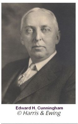
Edward H Cunningham
| Birth | : | 19 Dec 1869 Burlington, Racine County, Wisconsin, USA |
| Death | : | 28 Nov 1930 District of Columbia, USA |
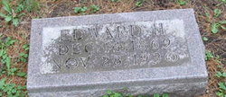
| Burial | : | Newell Cemetery, Newell, Buena Vista County, USA |
| Coordinate | : | 42.6123800, -94.9994800 |
| Description | : | Published in the Mason City Globe Gazette, November 29, 1930. Career of Iowa Member of Federal Reserve Ends Edward Cunningham Stricken by Heart Attack. WASHINGTON, NOV. 29 (AP)-The career of Edward H Cunningham as "servant to agriculture" in Iowa and the nation was at an end today. Cunningham, whose success as farmer and a leader of farm movements led to his appointment to the federal reserve board in 1923, died yesterday afternoon, a few minutes after he had been stricken with a heart attack at his desk in the treasury building. His body today lay in an undertaking establishment, pending the completion of... Read More |
frequently asked questions (FAQ):
-
Where is Edward H Cunningham's memorial?
Edward H Cunningham's memorial is located at: Newell Cemetery, Newell, Buena Vista County, USA.
-
When did Edward H Cunningham death?
Edward H Cunningham death on 28 Nov 1930 in District of Columbia, USA
-
Where are the coordinates of the Edward H Cunningham's memorial?
Latitude: 42.6123800
Longitude: -94.9994800
Family Members:
Flowers:
Nearby Cemetories:
1. Newell Cemetery
Newell, Buena Vista County, USA
Coordinate: 42.6123800, -94.9994800
2. Newell Catholic Prairie Cemetery
Newell, Buena Vista County, USA
Coordinate: 42.6144000, -95.0328000
3. Donna Lynn Salis-Christensen Burial Plot
Newell, Buena Vista County, USA
Coordinate: 42.5882134, -95.0544960
4. Varina Cemetery
Newell Township, Buena Vista County, USA
Coordinate: 42.6539993, -94.9339981
5. Saint Johns Church Of Christ Cemetery
Storm Lake, Buena Vista County, USA
Coordinate: 42.7108002, -95.0428009
6. Saint John's Lutheran Cemetery
Albert City, Buena Vista County, USA
Coordinate: 42.7200920, -94.9947630
7. Zion Lutheran Cemetery
Storm Lake, Buena Vista County, USA
Coordinate: 42.7136002, -95.0650024
8. Saint Columbkilles Cemetery
Varina, Pocahontas County, USA
Coordinate: 42.6467018, -94.8443985
9. Nemaha Cemetery
Nemaha, Sac County, USA
Coordinate: 42.5102997, -95.0905991
10. Cedar Township Cemetery
Fonda, Pocahontas County, USA
Coordinate: 42.5810000, -94.8375000
11. Saint Mary's Catholic Cemetery
Storm Lake, Buena Vista County, USA
Coordinate: 42.6470000, -95.1660000
12. Mount Zion Cemetery
Fonda, Pocahontas County, USA
Coordinate: 42.5821991, -94.8300018
13. Storm Lake Cemetery
Storm Lake, Buena Vista County, USA
Coordinate: 42.6352800, -95.1744400
14. Dover Township Cemetery
Varina, Pocahontas County, USA
Coordinate: 42.6896100, -94.8524200
15. Lincoln Township Cemetery
Buena Vista County, USA
Coordinate: 42.7413000, -95.1282000
16. Fairfield Cemetery
Albert City, Buena Vista County, USA
Coordinate: 42.7783012, -94.9692001
17. Saint John Cemetery
Williams Township, Calhoun County, USA
Coordinate: 42.4747009, -94.8672028
18. Marshall Cemetery
Pocahontas County, USA
Coordinate: 42.7633018, -94.8930969
19. Buena Vista Memorial Park Cemetery
Storm Lake, Buena Vista County, USA
Coordinate: 42.6539001, -95.2339020
20. Cedar Cemetery
Sac City, Sac County, USA
Coordinate: 42.4430000, -94.9110000
21. Sacred Heart Cemetery
Early, Sac County, USA
Coordinate: 42.4650002, -95.1446991
22. Immanuel Reformed Cemetery
Schaller, Sac County, USA
Coordinate: 42.5396996, -95.2294006
23. Oakland Cemetery
Sac City, Sac County, USA
Coordinate: 42.4272100, -94.9910760
24. Early Union Cemetery
Early, Sac County, USA
Coordinate: 42.4578018, -95.1425018


