
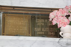
Edwin H. Zion
| Birth | : | 2 Oct 1879 Stanton County, Nebraska, USA |
| Death | : | 23 Dec 1940 Merced County, California, USA |
| Burial | : | Modesto Pioneer Cemetery, Modesto, Stanislaus County, USA |
| Coordinate | : | 37.6473350, -120.9829040 |
| Plot | : | N-B-2 |
| Description | : | #47030676: E. H. ZION, TWIN BROTHER AND WIFE DIED IN CRASH Atwater, Dec. 23.-- Three persons were killed here today in the headon automobile-truck collision. The dead were: E, H. Zion, prominent Modesto attorney and former assemblyman from Stanislaus County. William F. Zion, 60, Havre, Mont., retired executive of the great Northern Railroad. Mrs. William F. (Mary) Zion, 55, Havre, Mont. Robert Powell Zion, 17, son of E. H. Zion, was driving the car. He suffered serious injuries and was taken to the Mercy Hospital in Merced. The accident occurred during a heavy rainfall and officers believe the car skidded into the oncoming truck, which was driven by... Read More |
frequently asked questions (FAQ):
-
Where is Edwin H. Zion's memorial?
Edwin H. Zion's memorial is located at: Modesto Pioneer Cemetery, Modesto, Stanislaus County, USA.
-
When did Edwin H. Zion death?
Edwin H. Zion death on 23 Dec 1940 in Merced County, California, USA
-
Where are the coordinates of the Edwin H. Zion's memorial?
Latitude: 37.6473350
Longitude: -120.9829040
Family Members:
Parent

Spouse

Siblings
Flowers:


Nearby Cemetories:
1. Modesto Pioneer Cemetery
Modesto, Stanislaus County, USA
Coordinate: 37.6473350, -120.9829040
2. Acacia Memorial Park
Modesto, Stanislaus County, USA
Coordinate: 37.6481080, -120.9836610
3. Modesto Citizens Cemetery
Modesto, Stanislaus County, USA
Coordinate: 37.6472930, -120.9845570
4. Saint Stanislaus Catholic Cemetery
Modesto, Stanislaus County, USA
Coordinate: 37.6473610, -120.9808440
5. Modesto County Cemetery
Modesto, Stanislaus County, USA
Coordinate: 37.6492400, -120.9813800
6. Ceres Memorial Park
Ceres, Stanislaus County, USA
Coordinate: 37.5958214, -120.9634399
7. Lakewood Memorial Park
Hughson, Stanislaus County, USA
Coordinate: 37.6199760, -120.8975983
8. Good Shepherd Catholic Cemetery
Modesto, Stanislaus County, USA
Coordinate: 37.6853130, -121.0672890
9. Wood Colony Cemetery
Salida, Stanislaus County, USA
Coordinate: 37.6893730, -121.0682144
10. Burwood Cemetery
Escalon, San Joaquin County, USA
Coordinate: 37.7616997, -120.9593964
11. Langworth Cemetery
Oakdale, Stanislaus County, USA
Coordinate: 37.7580986, -120.8957977
12. Ripon Cemetery
Ripon, San Joaquin County, USA
Coordinate: 37.7420311, -121.1238708
13. Oakdale Citizens Cemetery
Oakdale, Stanislaus County, USA
Coordinate: 37.7624600, -120.8388800
14. Oaklawn Memorial Park
Oakdale, Stanislaus County, USA
Coordinate: 37.7711945, -120.8486862
15. Saint John's Catholic Cemetery
Escalon, San Joaquin County, USA
Coordinate: 37.7994537, -121.0705185
16. Denair Cemetery
Denair, Stanislaus County, USA
Coordinate: 37.5293999, -120.8199997
17. Martin Cemetery
Waterford, Stanislaus County, USA
Coordinate: 37.6684360, -120.7582160
18. Turlock Memorial Park
Turlock, Stanislaus County, USA
Coordinate: 37.4937592, -120.8659821
19. Grayson Cemetery
Grayson, Stanislaus County, USA
Coordinate: 37.5594559, -121.1802826
20. Valley Home Memorial Park
Oakdale, Stanislaus County, USA
Coordinate: 37.8275528, -120.9333267
21. Saint Francis Episcopal Church Columbarium
Turlock, Stanislaus County, USA
Coordinate: 37.5014300, -120.8368400
22. Patterson District Cemetery
Patterson, Stanislaus County, USA
Coordinate: 37.5268135, -121.1728287
23. Atlanta Cemetery
Five Corners, San Joaquin County, USA
Coordinate: 37.8270035, -121.1420135
24. North Hilmar Cemetery
Hilmar, Merced County, USA
Coordinate: 37.4146614, -120.8864288