
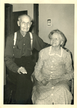
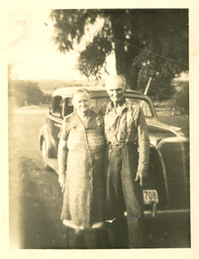
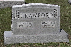

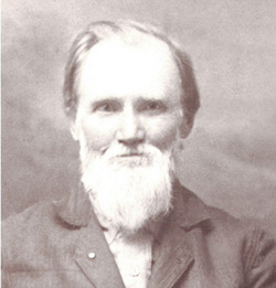
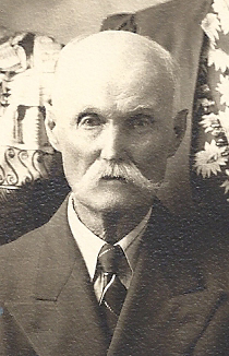
Edwin Harrison Crawford
| Birth | : | 23 May 1876 California, Moniteau County, Missouri, USA |
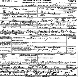
| Death | : | 2 Mar 1965 California, Moniteau County, Missouri, USA |
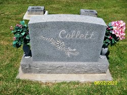
| Burial | : | Second Antioch Church Cemetery, Dorset, Powhatan County, USA |
| Coordinate | : | 37.4749320, -77.8070590 |
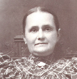
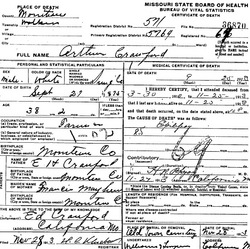
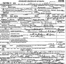
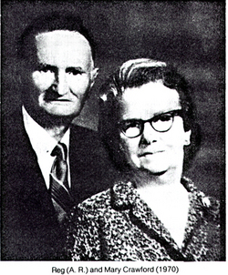
| Description | : | Edwin is the son of Edwin H & Francis A Mayhew Crawford. On 16 Jun 1901, in California MO, he married Ada Belle Allen. See her memorial for additional information and pictures. 1910 census, Moniteau Co, MO, Pilot Grove Township: (#62-67) Ed H. Crawford, Head,31, married 1 time, 9 yrs; b. MO; both parents b.MO; farmer. Bell, wife, 29, married 1 time, 9 yrs; 3 children born, 3 living; b.MO, both parents b.MO. Raymond L., son, 7 Arthur, son, 6 Dorsey, son, 6 mo 1920 census, MO, Moniteau County,Pilot Grove township Croford, Edwin,42,head,general farm ...Ada B,37,wife ...Raymond L,18,son ...Arthur R,15,son ...Dorsey,11,daughter (s/b son) Allen, Joel, 68,father in law,widowed,b.MO, both parents b.TN 1930 census... Read More |
frequently asked questions (FAQ):
-
Where is Edwin Harrison Crawford's memorial?
Edwin Harrison Crawford's memorial is located at: Second Antioch Church Cemetery, Dorset, Powhatan County, USA.
-
When did Edwin Harrison Crawford death?
Edwin Harrison Crawford death on 2 Mar 1965 in California, Moniteau County, Missouri, USA
-
Where are the coordinates of the Edwin Harrison Crawford's memorial?
Latitude: 37.4749320
Longitude: -77.8070590
Family Members:
Parent
Spouse
Siblings

Children


Nearby Cemetories:
1. Second Antioch Church Cemetery
Dorset, Powhatan County, USA
Coordinate: 37.4749320, -77.8070590
2. Graceland Baptist Church Cemetery
Powhatan, Powhatan County, USA
Coordinate: 37.4702988, -77.8066025
3. Taylor & Harrison
Huguenot, Powhatan County, USA
Coordinate: 37.4938770, -77.7936960
4. First Baptist Church Cemetery
Flat Rock, Powhatan County, USA
Coordinate: 37.5133020, -77.7914130
5. Genito Cemetery
Genito, Powhatan County, USA
Coordinate: 37.4608002, -77.8607025
6. Watkins Graveyard
Powhatan County, USA
Coordinate: 37.5117480, -77.7707390
7. Grace Cemetery
Genito, Powhatan County, USA
Coordinate: 37.4658012, -77.8657990
8. Rocky Oak Cemetery
Powhatan County, USA
Coordinate: 37.5189018, -77.8300018
9. Watkins Cemetery
Powhatan County, USA
Coordinate: 37.5236710, -77.8115780
10. Saint John Neumann Catholic Church Columbarium
Powhatan, Powhatan County, USA
Coordinate: 37.5242120, -77.8174340
11. Amos Family Cemetery
Powhatan, Powhatan County, USA
Coordinate: 37.5141500, -77.8515300
12. Mount Hermon Baptist Church Cemetery
Chesterfield, Chesterfield County, USA
Coordinate: 37.4539986, -77.7443008
13. Liberty Cemetery
Pilkinton, Powhatan County, USA
Coordinate: 37.4277992, -77.8414001
14. Haskins and Cheatham Burying Ground
Chesterfield County, USA
Coordinate: 37.4249100, -77.7746700
15. Old Powhatan Baptist Church Cemetery
Powhatan, Powhatan County, USA
Coordinate: 37.5277060, -77.7793280
16. Mount Calvary Baptist Church Cemetery
Powhatan, Powhatan County, USA
Coordinate: 37.5297390, -77.8499830
17. Red Lane Baptist Church Cemetery
Flat Rock, Powhatan County, USA
Coordinate: 37.5348015, -77.8482971
18. Crump Family Cemetery
Chesterfield County, USA
Coordinate: 37.4406145, -77.7229981
19. Willis Family Cemetery
Powhatan, Powhatan County, USA
Coordinate: 37.5477417, -77.7838469
20. Mattoax Presbyterian Church
Amelia County, USA
Coordinate: 37.4317017, -77.8972015
21. Subletts Cemetery
Powhatan County, USA
Coordinate: 37.5588989, -77.7928009
22. Beulah Baptist Church Cemetery
Chesterfield County, USA
Coordinate: 37.3885920, -77.7986960
23. Liberty Baptist Church Cemetery
Amelia Court House, Amelia County, USA
Coordinate: 37.4365200, -77.9090600
24. Powhatan Mennonite Church Cemetery
Powhatan, Powhatan County, USA
Coordinate: 37.5357180, -77.8951930