
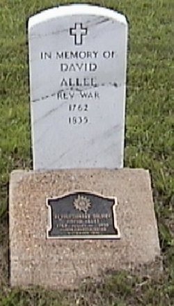


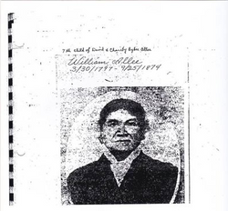
Elder David Allee
| Birth | : | 25 Apr 1762 Virginia, USA |
| Death | : | 3 Jan 1835 California, Moniteau County, Missouri, USA |
| Burial | : | Dane Lutheran Cemetery, Cowles, Webster County, USA |
| Coordinate | : | 40.1903000, -98.5947000 |
| Inscription | : | REVOLUTIONARY SOLDIER DAVID ALLEE 1762 PLACED BY 1835 ELDON CHAPTER NSDAR NOVEMBER 1999 |
| Description | : | RESEARCH & SOURCE: Transcript by: Alan Sparks (2006) Ref: Missouri Baptist Biography Missouri Baptist Historical Society, Vol. IV, Pg. 20-22. Emigated, Barren Co. Kentucky 1795 Military Pensions Records Veterans Administration (S. 16596) Enlisted from Henry Co. Virginia Revolunionary War. After David married Charity Bybee, he obtained 200 acres of land in Barren County, KY, from the state of Virginia for payment of his services on the Virginia Continental Line in the Revolutionary War. In addition to farming, David was ordained as a Baptist minister at the Glover Creek Church at Summer Shade, Barren, KY, where he preached from... Read More |
frequently asked questions (FAQ):
-
Where is Elder David Allee's memorial?
Elder David Allee's memorial is located at: Dane Lutheran Cemetery, Cowles, Webster County, USA.
-
When did Elder David Allee death?
Elder David Allee death on 3 Jan 1835 in California, Moniteau County, Missouri, USA
-
Where are the coordinates of the Elder David Allee's memorial?
Latitude: 40.1903000
Longitude: -98.5947000
Family Members:
Parent
Spouse
Children
Flowers:


Nearby Cemetories:
1. Dane Lutheran Cemetery
Cowles, Webster County, USA
Coordinate: 40.1903000, -98.5947000
2. Pleasant Prairie Cemetery
Inavale, Webster County, USA
Coordinate: 40.1464005, -98.6382980
3. New Virginia Cemetery
Webster County, USA
Coordinate: 40.1906013, -98.6678009
4. Catherton Cemetery
Webster County, USA
Coordinate: 40.2421989, -98.6324997
5. Plainview Cemetery
Bladen, Webster County, USA
Coordinate: 40.2841988, -98.5858002
6. Batin Cemetery
Cowles, Webster County, USA
Coordinate: 40.2299995, -98.4822006
7. Norwegian Zion Lutheran Cemetery
Inavale, Webster County, USA
Coordinate: 40.1913000, -98.7255000
8. Miner Ranch Cemetery
Red Cloud, Webster County, USA
Coordinate: 40.0774500, -98.5733500
9. Cloverton Cemetery
Bladen, Webster County, USA
Coordinate: 40.2989006, -98.5378036
10. Cowles Cemetery
Cowles, Webster County, USA
Coordinate: 40.1755000, -98.4425000
11. Murphy Cemetery
Red Cloud, Webster County, USA
Coordinate: 40.0744019, -98.5522003
12. Sacred Heart Cemetery
Red Cloud, Webster County, USA
Coordinate: 40.0807300, -98.5286700
13. Red Cloud Cemetery
Red Cloud, Webster County, USA
Coordinate: 40.0806961, -98.5270920
14. East Lawn Cemetery
Bladen, Webster County, USA
Coordinate: 40.3208008, -98.5886002
15. Saint Ann Cemetery
Webster County, USA
Coordinate: 40.2914009, -98.7093964
16. Harmony Cemetery
Bladen, Webster County, USA
Coordinate: 40.3218994, -98.6605988
17. Mount Pleasant Cemetery
Webster County, USA
Coordinate: 40.0491982, -98.6125031
18. Howe Cemetery
Webster County, USA
Coordinate: 40.2341730, -98.4154440
19. Trinity Lutheran Cemetery
Campbell, Franklin County, USA
Coordinate: 40.2625008, -98.7605972
20. Pleasant Hill Cemetery
Webster County, USA
Coordinate: 40.1178017, -98.4250031
21. Campbell Cemetery
Webster County, USA
Coordinate: 40.3064570, -98.7220340
22. Riverton Cemetery
Riverton, Franklin County, USA
Coordinate: 40.0970993, -98.7530975
23. Koch-Cook Cemetery
Franklin County, USA
Coordinate: 40.2917700, -98.7474800
24. Amboy Cemetery
Amboy, Webster County, USA
Coordinate: 40.1003150, -98.4297540