


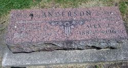
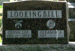
Eleanor Jean “Lookingbill” Anderson Wendlandt
| Birth | : | 19 Mar 1927 Newell, Buena Vista County, Iowa, USA |
| Death | : | 16 Feb 2020 Glendale, Maricopa County, Arizona, USA |
| Burial | : | Newell Cemetery, Newell, Buena Vista County, USA |
| Coordinate | : | 42.6123800, -94.9994800 |
| Description | : | March 19, 1927 to February 16, 2020 Eleanor Jean Wendlandt, a longtime resident of Spencer, Iowa and Sun City, Arizona, died February 16, 2020 at Orchard Pointe at Arrowhead in Glendale, Arizona. Eleanor was born on March 19, 1927, in Newell, Iowa to Alexander and Eulalia Anderson. She was the fourth of four children. Eleanor grew up on a small family farm during the Depression and World War II, along with her brothers Joel and Ken and sister Margaret. She remained extremely close to her siblings her entire life and even spent time with Margaret working in the... Read More |
frequently asked questions (FAQ):
-
Where is Eleanor Jean “Lookingbill” Anderson Wendlandt's memorial?
Eleanor Jean “Lookingbill” Anderson Wendlandt's memorial is located at: Newell Cemetery, Newell, Buena Vista County, USA.
-
When did Eleanor Jean “Lookingbill” Anderson Wendlandt death?
Eleanor Jean “Lookingbill” Anderson Wendlandt death on 16 Feb 2020 in Glendale, Maricopa County, Arizona, USA
-
Where are the coordinates of the Eleanor Jean “Lookingbill” Anderson Wendlandt's memorial?
Latitude: 42.6123800
Longitude: -94.9994800
Family Members:
Parent

Spouse

Siblings


Children
Flowers:


Nearby Cemetories:
1. Newell Cemetery
Newell, Buena Vista County, USA
Coordinate: 42.6123800, -94.9994800
2. Newell Catholic Prairie Cemetery
Newell, Buena Vista County, USA
Coordinate: 42.6144000, -95.0328000
3. Donna Lynn Salis-Christensen Burial Plot
Newell, Buena Vista County, USA
Coordinate: 42.5882134, -95.0544960
4. Varina Cemetery
Newell Township, Buena Vista County, USA
Coordinate: 42.6539993, -94.9339981
5. Saint Johns Church Of Christ Cemetery
Storm Lake, Buena Vista County, USA
Coordinate: 42.7108002, -95.0428009
6. Saint John's Lutheran Cemetery
Albert City, Buena Vista County, USA
Coordinate: 42.7200920, -94.9947630
7. Zion Lutheran Cemetery
Storm Lake, Buena Vista County, USA
Coordinate: 42.7136002, -95.0650024
8. Saint Columbkilles Cemetery
Varina, Pocahontas County, USA
Coordinate: 42.6467018, -94.8443985
9. Nemaha Cemetery
Nemaha, Sac County, USA
Coordinate: 42.5102997, -95.0905991
10. Cedar Township Cemetery
Fonda, Pocahontas County, USA
Coordinate: 42.5810000, -94.8375000
11. Saint Mary's Catholic Cemetery
Storm Lake, Buena Vista County, USA
Coordinate: 42.6470000, -95.1660000
12. Mount Zion Cemetery
Fonda, Pocahontas County, USA
Coordinate: 42.5821991, -94.8300018
13. Storm Lake Cemetery
Storm Lake, Buena Vista County, USA
Coordinate: 42.6352800, -95.1744400
14. Dover Township Cemetery
Varina, Pocahontas County, USA
Coordinate: 42.6896100, -94.8524200
15. Lincoln Township Cemetery
Buena Vista County, USA
Coordinate: 42.7413000, -95.1282000
16. Fairfield Cemetery
Albert City, Buena Vista County, USA
Coordinate: 42.7783012, -94.9692001
17. Saint John Cemetery
Williams Township, Calhoun County, USA
Coordinate: 42.4747009, -94.8672028
18. Marshall Cemetery
Pocahontas County, USA
Coordinate: 42.7633018, -94.8930969
19. Buena Vista Memorial Park Cemetery
Storm Lake, Buena Vista County, USA
Coordinate: 42.6539001, -95.2339020
20. Cedar Cemetery
Sac City, Sac County, USA
Coordinate: 42.4430000, -94.9110000
21. Sacred Heart Cemetery
Early, Sac County, USA
Coordinate: 42.4650002, -95.1446991
22. Immanuel Reformed Cemetery
Schaller, Sac County, USA
Coordinate: 42.5396996, -95.2294006
23. Oakland Cemetery
Sac City, Sac County, USA
Coordinate: 42.4272100, -94.9910760
24. Early Union Cemetery
Early, Sac County, USA
Coordinate: 42.4578018, -95.1425018