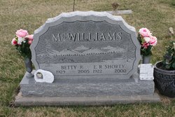
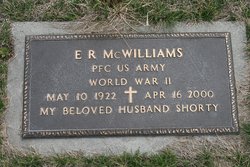
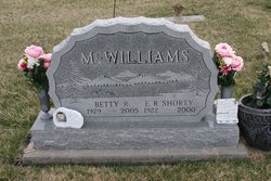
Elery Ray McWilliams
| Birth | : | 10 May 1922 Clarke County, Iowa, USA |
| Death | : | 16 Apr 2000 Osceola, Clarke County, Iowa, USA |
| Burial | : | Bethlehem Cemetery, Reedsville, Preston County, USA |
| Coordinate | : | 39.4817740, -79.7855120 |
frequently asked questions (FAQ):
-
Where is Elery Ray McWilliams's memorial?
Elery Ray McWilliams's memorial is located at: Bethlehem Cemetery, Reedsville, Preston County, USA.
-
When did Elery Ray McWilliams death?
Elery Ray McWilliams death on 16 Apr 2000 in Osceola, Clarke County, Iowa, USA
-
Where are the coordinates of the Elery Ray McWilliams's memorial?
Latitude: 39.4817740
Longitude: -79.7855120
Family Members:
Parent
Spouse
Siblings
Flowers:
Nearby Cemetories:
1. Bethlehem Cemetery
Reedsville, Preston County, USA
Coordinate: 39.4817740, -79.7855120
2. Fortney Cemetery
Preston County, USA
Coordinate: 39.4779930, -79.7898070
3. Fairfax Cemetery
Arthurdale, Preston County, USA
Coordinate: 39.4928000, -79.8134700
4. Zinn Cemetery
Arthurdale, Preston County, USA
Coordinate: 39.4865700, -79.8181400
5. Miles Cemetery
Reedsville, Preston County, USA
Coordinate: 39.5079872, -79.7834820
6. Hopewell Cemetery
Preston County, USA
Coordinate: 39.4544000, -79.7985000
7. Morgan Memorial Park
Reedsville, Preston County, USA
Coordinate: 39.5104600, -79.8002200
8. Reedsville Cemetery
Reedsville, Preston County, USA
Coordinate: 39.5104600, -79.8002200
9. Arthurdale Cemetery
Preston County, USA
Coordinate: 39.4958000, -79.8292007
10. Helm Family Cemetery
Howesville, Preston County, USA
Coordinate: 39.4461170, -79.8017860
11. Saint Joseph Catholic Cemetery
Howesville, Preston County, USA
Coordinate: 39.4507080, -79.7496300
12. Sunset Memorial Gardens
Kingwood, Preston County, USA
Coordinate: 39.4820880, -79.7291230
13. Zinns Chapel Cemetery
Reedsville, Preston County, USA
Coordinate: 39.5124970, -79.8366170
14. Gordon Cemetery
Preston County, USA
Coordinate: 39.4810600, -79.8509400
15. Howesville United Methodist Church Cemetery
Howesville, Preston County, USA
Coordinate: 39.4332085, -79.7604828
16. Rhodes Cemetery
Howesville, Preston County, USA
Coordinate: 39.4337550, -79.7427880
17. Irona Cemetery
Irona, Preston County, USA
Coordinate: 39.4497660, -79.7218390
18. Sapp-Weaver Cemetery
Gladesville, Preston County, USA
Coordinate: 39.4509400, -79.8523300
19. Pyles Cemetery
Birds Creek, Preston County, USA
Coordinate: 39.4207520, -79.8042270
20. Wesley Chapel Cemetery
Pleasantdale, Preston County, USA
Coordinate: 39.5260600, -79.7239100
21. Masontown Cemetery
Masontown, Preston County, USA
Coordinate: 39.5492220, -79.7985150
22. Adams Cemetery
Newburg, Preston County, USA
Coordinate: 39.4256130, -79.8356470
23. Pleasant Grove Cemetery
Herring, Preston County, USA
Coordinate: 39.5438309, -79.7385101
24. Pratt Cemetery
Preston County, USA
Coordinate: 39.4155998, -79.8233032

