
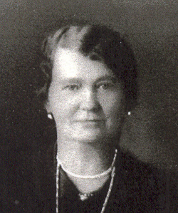

Eliza Ann Brown Hoke
| Birth | : | 25 Jun 1871 Montgomery County, Missouri, USA |
| Death | : | 15 Jan 1952 Red Lodge, Carbon County, Montana, USA |
| Burial | : | Grand Army of the Republic Cemetery, Devils Lake, Ramsey County, USA |
| Coordinate | : | 48.1166290, -98.8409690 |
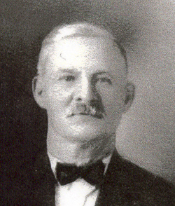
| Description | : | Eliza Hoke, 80, Passed Away in Red Lodge [Jan 1952]. Funeral services for Mrs. Eliza Hoke, 80, former resident of Phillips county, were held on Jan. 18 in Red Lodge. Burial was in the Belfry cemetery. Mrs. Hoke, aunt of Byron Bebee of Malta, died Jan. 15 in a nursing home. She had been in ill health for several months. The deceased was born June 25, 1871, in St. Louis, MO. She was married to George Hoke in 1888. They homesteaded near Red Lodge, until 1911 when... Read More |
frequently asked questions (FAQ):
-
Where is Eliza Ann Brown Hoke's memorial?
Eliza Ann Brown Hoke's memorial is located at: Grand Army of the Republic Cemetery, Devils Lake, Ramsey County, USA.
-
When did Eliza Ann Brown Hoke death?
Eliza Ann Brown Hoke death on 15 Jan 1952 in Red Lodge, Carbon County, Montana, USA
-
Where are the coordinates of the Eliza Ann Brown Hoke's memorial?
Latitude: 48.1166290
Longitude: -98.8409690
Family Members:
Parent
Spouse
Children


Nearby Cemetories:
1. Grand Army of the Republic Cemetery
Devils Lake, Ramsey County, USA
Coordinate: 48.1166290, -98.8409690
2. Saint Josephs Catholic Cemetery
Devils Lake, Ramsey County, USA
Coordinate: 48.1163180, -98.8411680
3. Solwey Ranch Cemetery
Saint Michael, Benson County, USA
Coordinate: 48.0252590, -98.8041880
4. Grand Harbor Cemetery
Ramsey County, USA
Coordinate: 48.1585999, -98.9897003
5. Zion Cemetery
Stevens Township, Ramsey County, USA
Coordinate: 48.0894740, -98.6809810
6. Saint Michaels Catholic Church Cemetery
Saint Michael, Benson County, USA
Coordinate: 47.9828160, -98.8713040
7. Native American Cemetery
Saint Michael, Benson County, USA
Coordinate: 47.9823376, -98.8706338
8. Saint Benedicts Cemetery
Crary, Ramsey County, USA
Coordinate: 48.1932880, -98.6588680
9. Sacred Heart Catholic Cemetery
Crary, Ramsey County, USA
Coordinate: 48.0566490, -98.6388450
10. Crary Cemetery
Crary, Ramsey County, USA
Coordinate: 48.0564003, -98.6382980
11. Norway Lutheran Church Cemetery
Devils Lake, Ramsey County, USA
Coordinate: 48.1397282, -99.0712715
12. Spirit Lake Assembly of God Cemetery
Fort Totten, Benson County, USA
Coordinate: 47.9883687, -99.0012872
13. Fort Totten Post Cemetery
Fort Totten, Benson County, USA
Coordinate: 47.9775800, -98.9930800
14. Webster Cemetery
Ramsey County, USA
Coordinate: 48.2813988, -98.9180984
15. Fox Lake Cemetery
Ramsey County, USA
Coordinate: 48.2164001, -98.5843964
16. Dakotah Oyate Lutheran Cemetery
Tokio, Benson County, USA
Coordinate: 47.9118878, -98.8243692
17. Saint Paul Cemetery
Ramsey County, USA
Coordinate: 48.2164001, -99.1138992
18. Bdecan Presbyterian Cemetery
Tokio, Benson County, USA
Coordinate: 47.9057400, -98.8252200
19. Saints Peter and Paul Catholic Cemetery
Ramsey County, USA
Coordinate: 48.3320500, -98.8343920
20. Saint Jeromes Catholic Cemetery
Fort Totten, Benson County, USA
Coordinate: 47.9877960, -99.0993510
21. Schneider Farm Cemetery
Crary, Ramsey County, USA
Coordinate: 48.2519798, -98.5887000
22. Scandinavia Cemetery
Webster, Ramsey County, USA
Coordinate: 48.3249660, -98.7438332
23. Doyon Cemetery
Doyon, Ramsey County, USA
Coordinate: 48.0438995, -98.5314026
24. Presbyterian Cemetery
Ramsey County, USA
Coordinate: 48.2235985, -99.1371994