
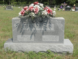
Eliza Louisa “Lizzie” Haus Cantrell
| Birth | : | 8 Oct 1860 Springfield, Greene County, Missouri, USA |
| Death | : | 16 Oct 1945 Myrtle, Oregon County, Missouri, USA |
| Burial | : | Grand Army of the Republic Cemetery, Devils Lake, Ramsey County, USA |
| Coordinate | : | 48.1166290, -98.8409690 |
| Description | : | Married Joseph P. Cantrell 13/Mar/1880 at Oregon Co., MO. Home maker. Per MO Death certificate #42019, burial 17/Oct/1945. Name on death certificate is Eliza Elizabeth. |
frequently asked questions (FAQ):
-
Where is Eliza Louisa “Lizzie” Haus Cantrell's memorial?
Eliza Louisa “Lizzie” Haus Cantrell's memorial is located at: Grand Army of the Republic Cemetery, Devils Lake, Ramsey County, USA.
-
When did Eliza Louisa “Lizzie” Haus Cantrell death?
Eliza Louisa “Lizzie” Haus Cantrell death on 16 Oct 1945 in Myrtle, Oregon County, Missouri, USA
-
Where are the coordinates of the Eliza Louisa “Lizzie” Haus Cantrell's memorial?
Latitude: 48.1166290
Longitude: -98.8409690
Family Members:
Spouse

Children

Flowers:


Nearby Cemetories:
1. Grand Army of the Republic Cemetery
Devils Lake, Ramsey County, USA
Coordinate: 48.1166290, -98.8409690
2. Saint Josephs Catholic Cemetery
Devils Lake, Ramsey County, USA
Coordinate: 48.1163180, -98.8411680
3. Solwey Ranch Cemetery
Saint Michael, Benson County, USA
Coordinate: 48.0252590, -98.8041880
4. Grand Harbor Cemetery
Ramsey County, USA
Coordinate: 48.1585999, -98.9897003
5. Zion Cemetery
Stevens Township, Ramsey County, USA
Coordinate: 48.0894740, -98.6809810
6. Saint Michaels Catholic Church Cemetery
Saint Michael, Benson County, USA
Coordinate: 47.9828160, -98.8713040
7. Native American Cemetery
Saint Michael, Benson County, USA
Coordinate: 47.9823376, -98.8706338
8. Saint Benedicts Cemetery
Crary, Ramsey County, USA
Coordinate: 48.1932880, -98.6588680
9. Sacred Heart Catholic Cemetery
Crary, Ramsey County, USA
Coordinate: 48.0566490, -98.6388450
10. Crary Cemetery
Crary, Ramsey County, USA
Coordinate: 48.0564003, -98.6382980
11. Norway Lutheran Church Cemetery
Devils Lake, Ramsey County, USA
Coordinate: 48.1397282, -99.0712715
12. Spirit Lake Assembly of God Cemetery
Fort Totten, Benson County, USA
Coordinate: 47.9883687, -99.0012872
13. Fort Totten Post Cemetery
Fort Totten, Benson County, USA
Coordinate: 47.9775800, -98.9930800
14. Webster Cemetery
Ramsey County, USA
Coordinate: 48.2813988, -98.9180984
15. Fox Lake Cemetery
Ramsey County, USA
Coordinate: 48.2164001, -98.5843964
16. Dakotah Oyate Lutheran Cemetery
Tokio, Benson County, USA
Coordinate: 47.9118878, -98.8243692
17. Saint Paul Cemetery
Ramsey County, USA
Coordinate: 48.2164001, -99.1138992
18. Bdecan Presbyterian Cemetery
Tokio, Benson County, USA
Coordinate: 47.9057400, -98.8252200
19. Saints Peter and Paul Catholic Cemetery
Ramsey County, USA
Coordinate: 48.3320500, -98.8343920
20. Saint Jeromes Catholic Cemetery
Fort Totten, Benson County, USA
Coordinate: 47.9877960, -99.0993510
21. Schneider Farm Cemetery
Crary, Ramsey County, USA
Coordinate: 48.2519798, -98.5887000
22. Scandinavia Cemetery
Webster, Ramsey County, USA
Coordinate: 48.3249660, -98.7438332
23. Doyon Cemetery
Doyon, Ramsey County, USA
Coordinate: 48.0438995, -98.5314026
24. Presbyterian Cemetery
Ramsey County, USA
Coordinate: 48.2235985, -99.1371994