
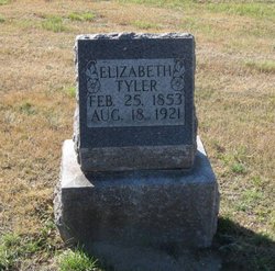
Elizabeth Brooks Tyler
| Birth | : | 25 Feb 1853 King, York Regional Municipality, Ontario, Canada |
| Death | : | 18 Aug 1921 Fort Benton, Chouteau County, Montana, USA |
| Burial | : | Big Sandy Cemetery, Big Sandy, Chouteau County, USA |
| Coordinate | : | 48.1801170, -110.1207500 |
| Description | : | The following provided by Find A Grave contributor "Cara": The Bear Paw Mountaineer, Big Sandy, MT, 1 Sept 1921 Mrs. Elizabeth Tyler died at the St. Clare hospital at Fort Benton, Thursday, Aug. 18, at 4:15 a.m., after a lingering illness of cancer of the stomach, although she had been in poor health her death was unexpected. Her remains were brought to Big Sandy Friday where they remained until Saturday when she was laid to rest in Big Sandy cemetery. A large crowd of family and friends attended the funeral. She was 68... Read More |
frequently asked questions (FAQ):
-
Where is Elizabeth Brooks Tyler's memorial?
Elizabeth Brooks Tyler's memorial is located at: Big Sandy Cemetery, Big Sandy, Chouteau County, USA.
-
When did Elizabeth Brooks Tyler death?
Elizabeth Brooks Tyler death on 18 Aug 1921 in Fort Benton, Chouteau County, Montana, USA
-
Where are the coordinates of the Elizabeth Brooks Tyler's memorial?
Latitude: 48.1801170
Longitude: -110.1207500
Family Members:
Flowers:


Nearby Cemetories:
1. Big Sandy Cemetery
Big Sandy, Chouteau County, USA
Coordinate: 48.1801170, -110.1207500
2. Box Elder Cemetery
Box Elder, Hill County, USA
Coordinate: 48.3274000, -110.0095000
3. Kenilworth Cemetery
Chouteau County, USA
Coordinate: 48.2192001, -110.4188995
4. Rocky Boy Cemetery
Rocky Boy, Hill County, USA
Coordinate: 48.2572410, -109.7923690
5. Rocky Boy Gravel Cemetery
Rocky Boy, Hill County, USA
Coordinate: 48.2427720, -109.7596500
6. Cottonwood Lutheran Church Cemetery
Havre, Hill County, USA
Coordinate: 48.4545000, -110.1748000
7. Gildford Hill County Cemetery
Gildford, Hill County, USA
Coordinate: 48.5778008, -110.2957993
8. Clear Lake Cemetery
Chouteau County, USA
Coordinate: 47.7731018, -110.2514038
9. Hingham Union Cemetery
Hingham, Hill County, USA
Coordinate: 48.5601570, -110.4178980
10. Sunset Garden Park
Havre, Hill County, USA
Coordinate: 48.5531006, -109.8019028
11. Graceville Cemetery
Chouteau County, USA
Coordinate: 47.7505989, -110.0875015
12. Hungry Hollow Cemetery
Blaine County, USA
Coordinate: 48.2103004, -109.4677963
13. Highland Cemetery
Havre, Hill County, USA
Coordinate: 48.5463982, -109.6900024
14. Mount Hope Cemetery
Havre, Hill County, USA
Coordinate: 48.5540000, -109.7050000
15. Calvary Cemetery
Havre, Hill County, USA
Coordinate: 48.5457000, -109.6883000
16. Rudyard Cemetery
Rudyard, Hill County, USA
Coordinate: 48.5659500, -110.5390000
17. Riverside Cemetery
Fort Benton, Chouteau County, USA
Coordinate: 47.8402330, -110.6408830
18. Old Shep Gravesite
Fort Benton, Chouteau County, USA
Coordinate: 47.8369000, -110.6557000
19. Milk River Valley Church Graveyard
Hill County, USA
Coordinate: 48.6787180, -110.2261080
20. Museum of the Upper Missouri
Fort Benton, Chouteau County, USA
Coordinate: 47.8207000, -110.6642000
21. Inverness Cemetery
Hill County, USA
Coordinate: 48.5531340, -110.6688450
22. Grainbelt Cemetery
Hill County, USA
Coordinate: 48.6828003, -109.8657990
23. Montague Cemetery
Chouteau County, USA
Coordinate: 47.6783000, -110.4670000
24. North Havre Lutheran Church Graveyard (Defunct)
Havre, Hill County, USA
Coordinate: 48.6538903, -109.6815870