
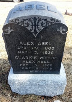
Elizabeth “Clarkie” Wade Abel
| Birth | : | 3 Oct 1862 Metcalfe County, Kentucky, USA |
| Death | : | 5 Jun 1908 Topeka, Shawnee County, Kansas, USA |
| Burial | : | Kingston Lawn Cemetery, Kingston, Kingborough Council, Australia |
| Coordinate | : | -42.9742220, 147.2829020 |
| Plot | : | Section 4 (west), Block 104, Lot 6 |
| Description | : | Our sister, Clarkie Abel. Sister Abel was born in Metcalfe county, Kentucky, October 3, 1862. She was the daughter of Rev. and Mrs. J. M. Wade and the wife of our friend and brother, Alexander Abel. She united with the St. Clere Baptist church at St. Clere, Kansas, a church which was organized by her father, and served by him as pastor, at the age of 15, and the balance of her life was a faithful and loyal member ... She was married to Alexander Abel May 5, 1881, and to them were born four children, three of whom, one... Read More |
frequently asked questions (FAQ):
-
Where is Elizabeth “Clarkie” Wade Abel's memorial?
Elizabeth “Clarkie” Wade Abel's memorial is located at: Kingston Lawn Cemetery, Kingston, Kingborough Council, Australia.
-
When did Elizabeth “Clarkie” Wade Abel death?
Elizabeth “Clarkie” Wade Abel death on 5 Jun 1908 in Topeka, Shawnee County, Kansas, USA
-
Where are the coordinates of the Elizabeth “Clarkie” Wade Abel's memorial?
Latitude: -42.9742220
Longitude: 147.2829020
Family Members:

Flowers:


Nearby Cemetories:
1. Kingston Lawn Cemetery
Kingston, Kingborough Council, Australia
Coordinate: -42.9742220, 147.2829020
2. Settlers’ Park Cemetery
Kingston, Kingborough Council, Australia
Coordinate: -42.9758830, 147.3054500
3. Saint Clements Anglican Cemetery
Kingston, Kingborough Council, Australia
Coordinate: -42.9754830, 147.3122690
4. Kingston Roman Catholic Cemetery
Kingston, Kingborough Council, Australia
Coordinate: -42.9763590, 147.3134030
5. North West Bay Cemetery
Margate, Kingborough Council, Australia
Coordinate: -43.0185480, 147.2540420
6. All Saints Anglican Cemetery
Margate, Kingborough Council, Australia
Coordinate: -43.0286810, 147.2630270
7. Saint Luke's Anglican Cemetery
Longley, Kingborough Council, Australia
Coordinate: -42.9751200, 147.1911800
8. Queenborough Cemetery
Sandy Bay, Hobart City, Australia
Coordinate: -42.9048420, 147.3313140
9. St. George's Burial Ground
Battery Point, Hobart City, Australia
Coordinate: -42.8915314, 147.3267267
10. St George Anglican Church Cemetery
Battery Point, Hobart City, Australia
Coordinate: -42.8914380, 147.3324820
11. Anglesea Barracks
Hobart, Hobart City, Australia
Coordinate: -42.8887860, 147.3242570
12. St. David's Park
Hobart, Hobart City, Australia
Coordinate: -42.8858767, 147.3285323
13. Davey Street Congregational Cemetery
Hobart, Hobart City, Australia
Coordinate: -42.8856150, 147.3278940
14. Snug Cemetery
Snug, Kingborough Council, Australia
Coordinate: -43.0673650, 147.2545440
15. St Mary’s Cathedral
Hobart, Hobart City, Australia
Coordinate: -42.8806220, 147.3191180
16. Harrington Street Cemetery
Hobart, Hobart City, Australia
Coordinate: -42.8801400, 147.3175940
17. Hobart Wesleyan Cemetery
Hobart, Hobart City, Australia
Coordinate: -42.8787920, 147.3104430
18. Lower Longley Methodist Cemetery
Longley Lower, Huon Valley Council, Australia
Coordinate: -42.9751080, 147.1477740
19. Friends' Park
Hobart, Hobart City, Australia
Coordinate: -42.8767052, 147.3080292
20. Saint Andrews Presbyterian Cemetery
Hobart, Hobart City, Australia
Coordinate: -42.8773519, 147.3213763
21. St. Barnabas Anglican Church Cemetery
South Arm, Clarence City, Australia
Coordinate: -43.0156858, 147.4160853
22. Saint Marks Anglican Cemetery
Bellerive, Clarence City, Australia
Coordinate: -42.8774700, 147.3691800
23. St John’s Anglican Church Cemetery
New Town, Hobart City, Australia
Coordinate: -42.8550230, 147.2969180
24. New Town Congregational Cemetery
New Town, Hobart City, Australia
Coordinate: -42.8545680, 147.3026230