

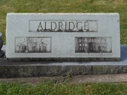
Elizabeth Dawn “Libby” Farmer Aldridge
| Birth | : | 1 Dec 1929 Montgomery County, Virginia, USA |
| Death | : | 22 Feb 1993 Copper Hill, Floyd County, Virginia, USA |
| Burial | : | Restvale Cemetery, Copper Hill, Floyd County, USA |
| Coordinate | : | 37.0493728, -80.1602634 |
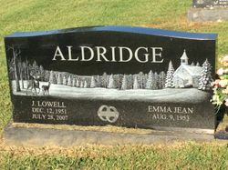
| Description | : | ALDRIDGE, Elizabeth Farmer, 63, of Bent Mountain, died Monday, February 22, 1993, at her home. Surviving are her husband, James C. Aldridge; one son and daughter-in-law, Lowell and Emma Jean Aldridge, all of Bent Mountain; two daughters and a son-in-law, Jennifer Aldridge of Roanoke, Ann and Wayne Penn of Fredericksburg; two grandsons, Travis Aldridge and Bryan Nester; one sister, Mary Thompson of Salem; two brothers, Earl Farmer of Roanoke, Bernice Farmer of Kingston, Tenn. Funeral Thursday 1 p.m. Copper Hill Church of the Brethren with the Rev. Douglas Jones and the Rev. Frank Wimmer officiating with interment in Restvale Cemetery.... Read More |
frequently asked questions (FAQ):
-
Where is Elizabeth Dawn “Libby” Farmer Aldridge's memorial?
Elizabeth Dawn “Libby” Farmer Aldridge's memorial is located at: Restvale Cemetery, Copper Hill, Floyd County, USA.
-
When did Elizabeth Dawn “Libby” Farmer Aldridge death?
Elizabeth Dawn “Libby” Farmer Aldridge death on 22 Feb 1993 in Copper Hill, Floyd County, Virginia, USA
-
Where are the coordinates of the Elizabeth Dawn “Libby” Farmer Aldridge's memorial?
Latitude: 37.0493728
Longitude: -80.1602634
Family Members:
Parent
Spouse
Siblings
Children


Flowers:


Nearby Cemetories:
1. Salem Church Cemetery
Copper Hill, Floyd County, USA
Coordinate: 37.0487010, -80.1599860
2. Poff Cemetery
Copper Hill, Floyd County, USA
Coordinate: 37.0520860, -80.1821390
3. Poff Cemetery
Indian Valley, Floyd County, USA
Coordinate: 37.0518990, -80.1821976
4. Gray Cemetery
Simpsons, Floyd County, USA
Coordinate: 37.0340140, -80.1732810
5. Sowder - King Cemetery
Copper Hill, Floyd County, USA
Coordinate: 37.0590774, -80.1336769
6. Prillaman Cemetery
Copper Hill, Floyd County, USA
Coordinate: 37.0462813, -80.1903636
7. Crossroads Union Chapel Cemetery
Copper Hill, Floyd County, USA
Coordinate: 37.0307240, -80.1317190
8. Jonas Larkin Wilson Family Cemetery
Floyd, Floyd County, USA
Coordinate: 37.0563010, -80.1223280
9. Munzing Family Cemetery
Copper Hill, Floyd County, USA
Coordinate: 37.0784603, -80.1454295
10. Nichols Cemetery
Copper Hill, Floyd County, USA
Coordinate: 37.0667000, -80.1241989
11. Riner-Willis Cemetery
Floyd County, USA
Coordinate: 37.0550050, -80.2019903
12. Puckett Cemetery
Copper Hill, Floyd County, USA
Coordinate: 37.0821560, -80.1374170
13. Hall Cemetery
Floyd County, USA
Coordinate: 37.0357107, -80.2056146
14. Hall and McNeil Cemetery
Floyd County, USA
Coordinate: 37.0360985, -80.2058029
15. Simpson - Barlow Cemetery
Floyd County, USA
Coordinate: 37.0145040, -80.1885120
16. Board Cemetery
Floyd County, USA
Coordinate: 37.0289500, -80.2060200
17. Walton Family Cemetery
Copper Hill, Floyd County, USA
Coordinate: 37.0223210, -80.1195170
18. Aldridge Cemetery
Copper Hill, Floyd County, USA
Coordinate: 37.0845930, -80.1301490
19. Copper Hill Church of the Brethren Cemetery
Copper Hill, Floyd County, USA
Coordinate: 37.0840560, -80.1283820
20. Link Family Cemetery
Simpsons, Floyd County, USA
Coordinate: 37.0566436, -80.2160247
21. Mills-Wimmer-Beckner Cemetery
Copper Hill, Floyd County, USA
Coordinate: 37.0834760, -80.1229370
22. Wimmer - Shaver - King Cemetery
Callaway, Franklin County, USA
Coordinate: 37.0689087, -80.1074751
23. Gray Cemetery
Copper Hill, Floyd County, USA
Coordinate: 37.0039900, -80.1414900
24. Shilling Cemetery
Floyd County, USA
Coordinate: 37.0779960, -80.1119940