
| Birth | : | 16 Oct 1898 Cherokee County, Iowa, USA |
| Death | : | 6 May 1995 Cherokee, Cherokee County, Iowa, USA |
| Burial | : | Kilcoy Cemetery, Kilcoy, Somerset Region, Australia |
| Coordinate | : | -26.9455258, 152.5522361 |
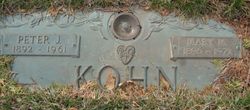
| Description | : | Elizabeth E. Kohn, 96, of Cherokee, Iowa, died Saturday May 6, 1995, in the Cherokee Villa, following an extended illness. She had been a resident of Cherokee County her entire life, previously living at 722 West Cherry for many years. Services were held Wednesday, May 11, 1995, at !0:30 a.m. at the Immaculate Conception Church, Cherokee. Rev. James Smith officiated. Burial was in the Mount Calvary Cemetery, Cherokee. She was born October 16, 1898, in Cherokee County to Peter and Elizabeth (Fischer) Kohn. Following her formal education, Elizabeth worked in Cherokee for many years. She had worked as a sales... Read More |
frequently asked questions (FAQ):
-
Where is Elizabeth E. Kohn's memorial?
Elizabeth E. Kohn's memorial is located at: Kilcoy Cemetery, Kilcoy, Somerset Region, Australia.
-
When did Elizabeth E. Kohn death?
Elizabeth E. Kohn death on 6 May 1995 in Cherokee, Cherokee County, Iowa, USA
-
Where are the coordinates of the Elizabeth E. Kohn's memorial?
Latitude: -26.9455258
Longitude: 152.5522361
Family Members:
Parent

Siblings
Flowers:


Nearby Cemetories:
1. Kilcoy Cemetery
Kilcoy, Somerset Region, Australia
Coordinate: -26.9455258, 152.5522361
2. Cressbrook Homestead Cemetery
Rochedale South, Logan City, Australia
Coordinate: -27.0603650, 152.4084090
3. Cressbrook Homestead Cemetery
Cressbrook, Somerset Region, Australia
Coordinate: -27.0578000, 152.4047000
4. Harlin General Cemetery
Harlin, Somerset Region, Australia
Coordinate: -26.9684600, 152.3536000
5. Toogoolawah Cemetery
Toogoolawah, Somerset Region, Australia
Coordinate: -27.0572990, 152.3794210
6. Caboonbah Church Cemetery
Caboonbah, Somerset Region, Australia
Coordinate: -27.1334046, 152.4675252
7. Woodford Cemetery
Woodford, Moreton Bay Region, Australia
Coordinate: -26.9458580, 152.7866720
8. Mount Mee Cemetery
Mount Mee, Moreton Bay Region, Australia
Coordinate: -27.0586281, 152.7549438
9. Moore-Linville Cemetery
Moore, Somerset Region, Australia
Coordinate: -26.8773340, 152.2965680
10. Fairview Cemetery
Bryden, Somerset Region, Australia
Coordinate: -27.2057004, 152.5536795
11. Bryden Catholic Cemetery
Bryden, Somerset Region, Australia
Coordinate: -27.2426026, 152.5698927
12. Peachester Cemetery
Crohamhurst, Sunshine Coast Council, Australia
Coordinate: -26.8199922, 152.8714523
13. Esk Cemetery
Esk, Somerset Region, Australia
Coordinate: -27.2394293, 152.4163463
14. Grigor Children
Glass House Mountains, Sunshine Coast Council, Australia
Coordinate: -26.9166600, 152.9228750
15. Dayboro Cemetery
Dayboro, Moreton Bay Region, Australia
Coordinate: -27.1912910, 152.8129120
16. Witta Cemetery
Witta, Sunshine Coast Council, Australia
Coordinate: -26.7061560, 152.8270080
17. Upper Caboolture Uniting Church Cemetery
Upper Caboolture, Moreton Bay Region, Australia
Coordinate: -27.1071200, 152.8945300
18. Beerburrum Cemetery
Beerburrum, Sunshine Coast Council, Australia
Coordinate: -26.9490050, 152.9547500
19. Caboolture Cemetery
Caboolture, Moreton Bay Region, Australia
Coordinate: -27.0856520, 152.9397800
20. Australia Zoo
Beerwah, Sunshine Coast Council, Australia
Coordinate: -26.8361140, 152.9615310
21. Blackbutt-Benarkin Cemetery
Blackbutt, South Burnett Region, Australia
Coordinate: -26.8877200, 152.1261340
22. St Mary's Church
Montville, Sunshine Coast Council, Australia
Coordinate: -26.6879465, 152.8926176
23. Beerwah Cemetery
Beerwah, Sunshine Coast Council, Australia
Coordinate: -26.8521020, 152.9875450
24. Flaxton Cemetery
Flaxton, Sunshine Coast Council, Australia
Coordinate: -26.6617420, 152.8731570