
| Birth | : | 26 Jan 1841 Adair County, Kentucky, USA |
| Death | : | 8 Aug 1930 Kansas City, Jackson County, Missouri, USA |
| Burial | : | Montlawn Memorial Park, Raleigh, Wake County, USA |
| Coordinate | : | 35.7378006, -78.6468964 |
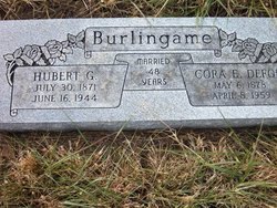
| Description | : | Daughter of William Elliott, married twice; 1) Francis Scott Burlingame, December 23, 1860, Latham, Moniteau County, Missouri, and then to his brother 2) Asa Franklin Burlingame, Jr. (with whom she is interred), March 25, 1866, Saline Township, Miller County, Missouri. |
frequently asked questions (FAQ):
-
Where is Elizabeth Elliott Burlingame's memorial?
Elizabeth Elliott Burlingame's memorial is located at: Montlawn Memorial Park, Raleigh, Wake County, USA.
-
When did Elizabeth Elliott Burlingame death?
Elizabeth Elliott Burlingame death on 8 Aug 1930 in Kansas City, Jackson County, Missouri, USA
-
Where are the coordinates of the Elizabeth Elliott Burlingame's memorial?
Latitude: 35.7378006
Longitude: -78.6468964
Family Members:
Parent
Spouse

Siblings
Children
Flowers:


Nearby Cemetories:
1. Montlawn Memorial Park
Raleigh, Wake County, USA
Coordinate: 35.7378006, -78.6468964
2. Hillcrest Cemetery
Raleigh, Wake County, USA
Coordinate: 35.7552640, -78.6311660
3. Caraleigh Mills Cemetery
Raleigh, Wake County, USA
Coordinate: 35.7591100, -78.6582700
4. Ernest Myatt Presbyterian Church Cemetery
Raleigh, Wake County, USA
Coordinate: 35.7136660, -78.6581080
5. Perkinson Family Cemetery (Defunct)
Garner, Wake County, USA
Coordinate: 35.7127590, -78.6369420
6. Mount Hope Cemetery
Raleigh, Wake County, USA
Coordinate: 35.7644005, -78.6461029
7. Inwood Baptist Church Cemetery
Raleigh, Wake County, USA
Coordinate: 35.7310750, -78.6832800
8. Wake Baptist Grove Church Cemetery
Garner, Wake County, USA
Coordinate: 35.7126999, -78.6246109
9. Carolina Biblical Gardens
Garner, Wake County, USA
Coordinate: 35.7355995, -78.6044006
10. Emery Family Cemetery
Raleigh, Wake County, USA
Coordinate: 35.7445230, -78.6888260
11. Peace Chapel of Deliverance Cemetery
Garner, Wake County, USA
Coordinate: 35.7112340, -78.6150690
12. Dorothea Dix Hospital Cemetery
Raleigh, Wake County, USA
Coordinate: 35.7730000, -78.6615000
13. City Cemetery
Raleigh, Wake County, USA
Coordinate: 35.7780190, -78.6323700
14. First Presbyterian Church Columbarium
Raleigh, Wake County, USA
Coordinate: 35.7794430, -78.6404610
15. Macedonia Cemetery
Wake County, USA
Coordinate: 35.7456017, -78.6977997
16. Church of the Good Shepherd Cemetery
Raleigh, Wake County, USA
Coordinate: 35.7800910, -78.6412450
17. Penny Family Cemetery
Garner, Wake County, USA
Coordinate: 35.7181460, -78.6938240
18. Old Poplar Springs United Church Of Christ Cemeter
Garner, Wake County, USA
Coordinate: 35.6947180, -78.6528050
19. Christ Church Memorial Garden
Raleigh, Wake County, USA
Coordinate: 35.7807010, -78.6375360
20. Edenton Street United Methodist Columbarium
Raleigh, Wake County, USA
Coordinate: 35.7817370, -78.6428220
21. Hilliard Family Cemetery
Garner, Wake County, USA
Coordinate: 35.7221985, -78.5942001
22. Rand Street United Church of Christ Cemetery
Garner, Wake County, USA
Coordinate: 35.7018940, -78.6074570
23. Hayes Chapel Christian Church Cemetery
Garner, Wake County, USA
Coordinate: 35.7066570, -78.6012180
24. Oakwood Cemetery
Raleigh, Wake County, USA
Coordinate: 35.7847595, -78.6293030