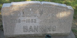
Elizabeth Jane “Jennie” Roush Banning
| Birth | : | 17 Nov 1870 Van Buren County, Iowa, USA |
| Death | : | 1944 Nebraska, USA |
| Burial | : | Center Cemetery, Rocky Hill, Hartford County, USA |
| Coordinate | : | 41.6605988, -72.6389008 |
| Plot | : | H |
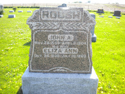
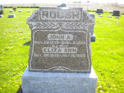
| Description | : | Married Sept 6, 1899 in Van Buren co, Iowa to William B. Banning(1869-1952) Her Parents are: Eliza Ann Davis Roush(1840-1880) and John Alexander Roush(1835-1904).Both parents are buried in Lebanon cem, Van Buren co, Iowa. This info from Iowa 1899 marriage license, where she called herself Jennie E. and from Davis family records of this family. Information provided by Dean Stevens. |
frequently asked questions (FAQ):
-
Where is Elizabeth Jane “Jennie” Roush Banning's memorial?
Elizabeth Jane “Jennie” Roush Banning's memorial is located at: Center Cemetery, Rocky Hill, Hartford County, USA.
-
When did Elizabeth Jane “Jennie” Roush Banning death?
Elizabeth Jane “Jennie” Roush Banning death on 1944 in Nebraska, USA
-
Where are the coordinates of the Elizabeth Jane “Jennie” Roush Banning's memorial?
Latitude: 41.6605988
Longitude: -72.6389008
Family Members:
Parent
Siblings
Flowers:
Nearby Cemetories:
1. Center Cemetery
Rocky Hill, Hartford County, USA
Coordinate: 41.6605988, -72.6389008
2. Colonel Raymond F. Gates Memorial Cemetery
Rocky Hill, Hartford County, USA
Coordinate: 41.6512718, -72.6548615
3. Rose Hill Memorial Park
Rocky Hill, Hartford County, USA
Coordinate: 41.6547012, -72.6588974
4. Saint Andrews Church Memorial Garden
Rocky Hill, Hartford County, USA
Coordinate: 41.6671830, -72.6586290
5. Old South Cemetery
South Glastonbury, Hartford County, USA
Coordinate: 41.6585999, -72.6042023
6. Saint Augustine Cemetery
Glastonbury, Hartford County, USA
Coordinate: 41.6646996, -72.5952988
7. Old Church Cemetery
South Glastonbury, Hartford County, USA
Coordinate: 41.6814003, -72.6007996
8. Bethany Lutheran Church Memorial Garden
Cromwell, Middlesex County, USA
Coordinate: 41.6214800, -72.6623400
9. Green Cemetery
Glastonbury, Hartford County, USA
Coordinate: 41.7014008, -72.6053009
10. Wethersfield Village Cemetery
Wethersfield, Hartford County, USA
Coordinate: 41.7116013, -72.6499481
11. West Cemetery
Cromwell, Middlesex County, USA
Coordinate: 41.6075134, -72.6573639
12. Trinity Parish Memorial Garden
Wethersfield, Hartford County, USA
Coordinate: 41.7148190, -72.6522590
13. Old Center Cemetery
Cromwell, Middlesex County, USA
Coordinate: 41.6065178, -72.6573486
14. Saint James Episcopal Church Memorial Garden
Glastonbury, Hartford County, USA
Coordinate: 41.7146200, -72.6101870
15. Hilltop Covenant Church Memorial Garden
Cromwell, Middlesex County, USA
Coordinate: 41.6049700, -72.6681000
16. Saint James Cemetery
Glastonbury, Hartford County, USA
Coordinate: 41.7158012, -72.6078033
17. Saint John the Baptist Ukranian Catholic Cemetery
Glastonbury, Hartford County, USA
Coordinate: 41.6960983, -72.5733032
18. Beckley Cemetery
Berlin, Hartford County, USA
Coordinate: 41.6447560, -72.7175720
19. Wethersfield State Prison Cemetery
Wethersfield, Hartford County, USA
Coordinate: 41.7195360, -72.6603130
20. Saint Michaels Ukrainian Catholic Church Cemetery
Glastonbury, Hartford County, USA
Coordinate: 41.6962013, -72.5724030
21. Our Saviour Cemetery
Glastonbury, Hartford County, USA
Coordinate: 41.7033005, -72.5725021
22. Old Burying Ground
Cromwell, Middlesex County, USA
Coordinate: 41.5954018, -72.6509171
23. Kelsey Cemetery
Cromwell, Middlesex County, USA
Coordinate: 41.6091232, -72.6994476
24. Congregation Bnai Sholom Cemetery
Wethersfield, Hartford County, USA
Coordinate: 41.7170400, -72.6955200

