
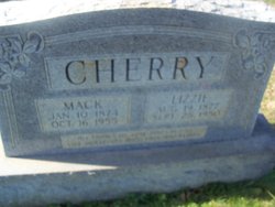
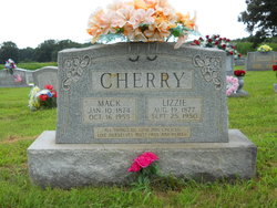
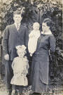
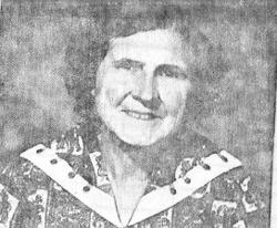
Elizabeth Jane “Lizzie” Long Cherry
| Birth | : | 19 Aug 1877 Tennessee, USA |
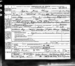
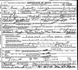
| Death | : | 25 Jul 1950 Clay County, Tennessee, USA |
| Burial | : | Grand Island Cemetery, Grand Island, Hall County, USA |
| Coordinate | : | 40.9048830, -98.3721500 |
frequently asked questions (FAQ):
-
Where is Elizabeth Jane “Lizzie” Long Cherry's memorial?
Elizabeth Jane “Lizzie” Long Cherry's memorial is located at: Grand Island Cemetery, Grand Island, Hall County, USA.
-
When did Elizabeth Jane “Lizzie” Long Cherry death?
Elizabeth Jane “Lizzie” Long Cherry death on 25 Jul 1950 in Clay County, Tennessee, USA
-
Where are the coordinates of the Elizabeth Jane “Lizzie” Long Cherry's memorial?
Latitude: 40.9048830
Longitude: -98.3721500
Family Members:
Parent
Spouse
Siblings

Children
Flowers:


Nearby Cemetories:
1. Grand Island Cemetery
Grand Island, Hall County, USA
Coordinate: 40.9048830, -98.3721500
2. First Presbyterian Columbarium
Grand Island, Hall County, USA
Coordinate: 40.9097000, -98.3568000
3. Westlawn Memorial Cemetery
Grand Island, Hall County, USA
Coordinate: 40.9039000, -98.3889010
4. Saint Stephens Church Columbarium
Grand Island, Hall County, USA
Coordinate: 40.9234000, -98.3435000
5. Trinity United Methodist Church Columbarium
Grand Island, Hall County, USA
Coordinate: 40.9275000, -98.3472000
6. Soldiers And Sailors Cemetery
Grand Island, Hall County, USA
Coordinate: 40.9467010, -98.3775024
7. East Grand Island Cemetery
Grand Island, Hall County, USA
Coordinate: 40.9446983, -98.3103027
8. Poor Farm Cemetery
Grand Island, Hall County, USA
Coordinate: 40.9745000, -98.3597000
9. Alda Cemetery
Alda, Hall County, USA
Coordinate: 40.8594017, -98.4749985
10. Jacob W Harper Burial Site
Adams County, USA
Coordinate: 40.8108130, -98.3516480
11. Phillips Cemetery
Phillips, Hamilton County, USA
Coordinate: 40.8736000, -98.2350006
12. Goettsche-Tramm Burial Site
Merrick County, USA
Coordinate: 40.9583800, -98.2364400
13. Cedar View Cemetery
Doniphan, Hall County, USA
Coordinate: 40.7846146, -98.3594055
14. Campbell Cemetery
Doniphan, Hall County, USA
Coordinate: 40.7780991, -98.4083023
15. Wiegert Cemetery
Hall County, USA
Coordinate: 41.0243988, -98.2822037
16. Berwick Cemetery
Cairo, Hall County, USA
Coordinate: 40.9636002, -98.5588989
17. Laurel Cemetery
Chapman, Merrick County, USA
Coordinate: 40.9915600, -98.1950710
18. Haggart Cemetery
Saint Libory, Howard County, USA
Coordinate: 41.0698500, -98.3547500
19. Wood River Cemetery
Wood River, Hall County, USA
Coordinate: 40.8218994, -98.5693970
20. Saint Libory Catholic Cemetery
Saint Libory, Howard County, USA
Coordinate: 41.0828700, -98.3569700
21. Wood River Mennonite Church Cemetery
Wood River, Hall County, USA
Coordinate: 40.8887460, -98.6262510
22. Rosedale Cemetery
Doniphan, Hall County, USA
Coordinate: 40.7125015, -98.4353027
23. Chapman Cemetery
Chapman, Merrick County, USA
Coordinate: 41.0163994, -98.1547012
24. Monroe Evangelical Free Church Cemetery
Murphy, Hamilton County, USA
Coordinate: 40.9449000, -98.1125000