
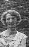


Elizabeth Lillian “Bessie” Yarolem Myhlhousen
| Birth | : | 1 Dec 1887 Jackson County, Iowa, USA |
| Death | : | 15 Feb 1954 Cedar Rapids, Linn County, Iowa, USA |
| Burial | : | Union Cemetery, Brookfield Township, Clinton County, USA |
| Coordinate | : | 42.0182991, -90.6694031 |
frequently asked questions (FAQ):
-
Where is Elizabeth Lillian “Bessie” Yarolem Myhlhousen's memorial?
Elizabeth Lillian “Bessie” Yarolem Myhlhousen's memorial is located at: Union Cemetery, Brookfield Township, Clinton County, USA.
-
When did Elizabeth Lillian “Bessie” Yarolem Myhlhousen death?
Elizabeth Lillian “Bessie” Yarolem Myhlhousen death on 15 Feb 1954 in Cedar Rapids, Linn County, Iowa, USA
-
Where are the coordinates of the Elizabeth Lillian “Bessie” Yarolem Myhlhousen's memorial?
Latitude: 42.0182991
Longitude: -90.6694031
Family Members:
Parent

Spouse
Siblings
Children
Flowers:


Nearby Cemetories:
1. Union Cemetery
Brookfield Township, Clinton County, USA
Coordinate: 42.0182991, -90.6694031
2. Sacred Heart Cemetery
Maquoketa, Jackson County, USA
Coordinate: 42.0583496, -90.6617966
3. Saint Patrick's Cemetery
Delmar, Clinton County, USA
Coordinate: 42.0036011, -90.6149979
4. Mount Hope Cemetery
Maquoketa, Jackson County, USA
Coordinate: 42.0615616, -90.6619720
5. Elwood Cemetery
Elwood, Clinton County, USA
Coordinate: 41.9935989, -90.7307968
6. Goddard Cemetery
Maquoketa, Jackson County, USA
Coordinate: 42.0391998, -90.7335968
7. Evergreen Cemetery
Delmar, Clinton County, USA
Coordinate: 41.9897003, -90.6057968
8. Buckhorn Waterford Cemetery
Buckhorn, Jackson County, USA
Coordinate: 42.0607986, -90.7517014
9. Bridgeport Cemetery
Maquoketa, Jackson County, USA
Coordinate: 42.0906000, -90.6267000
10. Bloomfield Cemetery
Clinton County, USA
Coordinate: 41.9458008, -90.6194000
11. Busch Cemetery
Clinton County, USA
Coordinate: 41.9996986, -90.7818985
12. Codfish Hollow Cemetery
Maquoketa, Jackson County, USA
Coordinate: 42.0727997, -90.5793991
13. Rathbun Cemetery
Maquoketa, Jackson County, USA
Coordinate: 42.0402000, -90.5570000
14. Pine Hill Cemetery
Bliedorn, Clinton County, USA
Coordinate: 41.9309300, -90.6836500
15. Saint Columbkille Cemetery
Bliedorn, Clinton County, USA
Coordinate: 41.9337330, -90.7039300
16. Tilton Cemetery
Jackson County, USA
Coordinate: 42.1236000, -90.6798000
17. Oakview Cemetery
Welton, Clinton County, USA
Coordinate: 41.9197930, -90.6031520
18. Union Center Cemetery
Maquoketa, Jackson County, USA
Coordinate: 42.0546989, -90.5246964
19. Immaculate Conception Cemetery
Petersville, Clinton County, USA
Coordinate: 41.9663000, -90.5332000
20. Rustic Park
Clinton County, USA
Coordinate: 41.9712334, -90.8088684
21. Esgate Cemetery
Maquoketa, Jackson County, USA
Coordinate: 42.1292000, -90.7142029
22. Seventh Day Baptist Cemetery
Welton, Clinton County, USA
Coordinate: 41.9130000, -90.6017000
23. Pence Cemetery
Baldwin, Jackson County, USA
Coordinate: 42.0746994, -90.8106003
24. Lost Nation Cemetery
Lost Nation, Clinton County, USA
Coordinate: 41.9654000, -90.8184000