

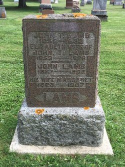
Elizabeth Rowand Lamb
| Birth | : | 22 Mar 1859 Brant Township, Bruce County, Ontario, Canada |
| Death | : | 11 Dec 1926 Walkerton, Bruce County, Ontario, Canada |
| Burial | : | Walkerton Cemetery, Walkerton, Bruce County, Canada |
| Coordinate | : | 44.1160316, -81.1448898 |
| Description | : | John Todd Lamb, 27, son of John Lamb and Margaret Lamb, married Elizabeth Rowand, 26, daughter of Andrew Rowand and Elizabeth Rowand, on 29 Oct 1885, at Brant, Bruce, ONT, Canada, per marriage record. |
frequently asked questions (FAQ):
-
Where is Elizabeth Rowand Lamb's memorial?
Elizabeth Rowand Lamb's memorial is located at: Walkerton Cemetery, Walkerton, Bruce County, Canada.
-
When did Elizabeth Rowand Lamb death?
Elizabeth Rowand Lamb death on 11 Dec 1926 in Walkerton, Bruce County, Ontario, Canada
-
Where are the coordinates of the Elizabeth Rowand Lamb's memorial?
Latitude: 44.1160316
Longitude: -81.1448898
Family Members:
Parent

Spouse
Siblings

Children
Flowers:


Nearby Cemetories:
1. Walkerton Cemetery
Walkerton, Bruce County, Canada
Coordinate: 44.1160316, -81.1448898
2. Calvary Cemetery
Walkerton, Bruce County, Canada
Coordinate: 44.1134260, -81.1467700
3. Presbyterian Pioneer Cemetery
Walkerton, Bruce County, Canada
Coordinate: 44.1302500, -81.1407000
4. Anglican Pioneer Cemetery
Walkerton, Bruce County, Canada
Coordinate: 44.1380939, -81.1438976
5. McLean's Cemetery
Brockton, Bruce County, Canada
Coordinate: 44.1295962, -81.1863350
6. Bethel Methodist Old Pioneer Cemetery
Brant Township, Bruce County, Canada
Coordinate: 44.1298270, -81.1863640
7. McDuff's Corner Cemetery
Brockton, Bruce County, Canada
Coordinate: 44.1090000, -81.1987000
8. Saint John's Evangelical Lutheran Cemetery new
Carrick Township, Bruce County, Canada
Coordinate: 44.0637740, -81.1029190
9. Saint John's Evangelical Lutheran Cemetery Old
Carrick Township, Bruce County, Canada
Coordinate: 44.0672000, -81.0833000
10. Salem Evangelical United Brethren Cemetery
Carrick Township, Bruce County, Canada
Coordinate: 44.0678000, -81.0784000
11. Immaculate Conception Roman Catholic Cemetery
Formosa, Bruce County, Canada
Coordinate: 44.0674591, -81.2140503
12. Saint Francis Xavier Catholic Cemetery
Carlsruhe, Bruce County, Canada
Coordinate: 44.1108856, -81.0459747
13. Saint John's Evangelical Lutheran Cemetery Lot 20
Brant Township, Bruce County, Canada
Coordinate: 44.1922600, -81.1401700
14. Brocklebank Methodist Cemetery
Brockton, Bruce County, Canada
Coordinate: 44.1812000, -81.0884000
15. Greenock Methodist United Church Cemetery
Greenock Township, Bruce County, Canada
Coordinate: 44.1007540, -81.2556340
16. St. Matthews Lutheran Cemetery
Mildmay, Bruce County, Canada
Coordinate: 44.0338000, -81.1252000
17. First Saint Peters Lutheran Cemetery
Brockton, Bruce County, Canada
Coordinate: 44.1827640, -81.0731150
18. Carrick Baptist Cemetery
Carrick Township, Bruce County, Canada
Coordinate: 44.0729880, -81.0438580
19. Sacred Heart Roman Catholic Cemetery
Mildmay, Bruce County, Canada
Coordinate: 44.0328000, -81.1243000
20. Mildmay United Church Cemetery
Mildmay, Bruce County, Canada
Coordinate: 44.0356900, -81.1068600
21. Saint Ignatius Roman Catholic Cemetery
Deemerton, Bruce County, Canada
Coordinate: 44.0473747, -81.0746384
22. Crispin Cemetery
Hanover, Grey County, Canada
Coordinate: 44.1372700, -81.0276000
23. Hanover Cemetery
Hanover, Grey County, Canada
Coordinate: 44.1382408, -81.0263901
24. Saint Peter's Lutheran Second Cemetery
Brant Township, Bruce County, Canada
Coordinate: 44.1891070, -81.0636100