
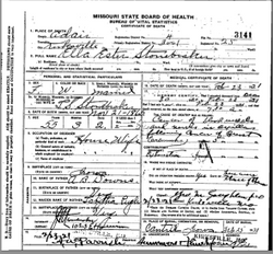
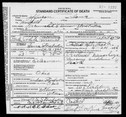
Ella Ester Downs Stonebraker
| Birth | : | 21 Nov 1865 Cantril, Van Buren County, Iowa, USA |
| Death | : | 23 Feb 1921 Kirksville, Adair County, Missouri, USA |
| Burial | : | Maple Grove Cemetery, Cantril, Van Buren County, USA |
| Coordinate | : | 40.6385994, -92.0681000 |
| Description | : | **Handwritten: 1921 Obituary of Mrs. T.S. Stonebraker. Ella Downs was born on the Downs farm, located about four miles east of Cantril, and passed to her reward at Kirksville, Mo., Feb. 23, 1921, at an early hour of the day. She was married to T.S. Stonebraker December 24, 1884. To this union was born one son, J.N. Stonebraker, of Kirksville, Mo. She is survived by the husband, son and wife, and two grandchildren, J. Nelson and Jack; two sisters, Rachel M. Rider, of Cantril, and Jennie S. Mills, of Edmund, Okla.; one brother, A.B. Downs, of Guadalajara, Mexico.... Read More |
frequently asked questions (FAQ):
-
Where is Ella Ester Downs Stonebraker's memorial?
Ella Ester Downs Stonebraker's memorial is located at: Maple Grove Cemetery, Cantril, Van Buren County, USA.
-
When did Ella Ester Downs Stonebraker death?
Ella Ester Downs Stonebraker death on 23 Feb 1921 in Kirksville, Adair County, Missouri, USA
-
Where are the coordinates of the Ella Ester Downs Stonebraker's memorial?
Latitude: 40.6385994
Longitude: -92.0681000
Family Members:
Parent
Spouse
Siblings

Children
Flowers:


Nearby Cemetories:
1. Maple Grove Cemetery
Cantril, Van Buren County, USA
Coordinate: 40.6385994, -92.0681000
2. Koellner Cemetery
Cantril, Van Buren County, USA
Coordinate: 40.6205700, -92.0694900
3. Mantonye Cemetery
Van Buren County, USA
Coordinate: 40.6264000, -92.0248000
4. Kaiser Cemetery
Cantril, Van Buren County, USA
Coordinate: 40.6617600, -92.0249800
5. Upton Cemetery
Cantril, Van Buren County, USA
Coordinate: 40.6074030, -92.0338380
6. East Home Prairie Cemetery
Keosauqua, Van Buren County, USA
Coordinate: 40.6750287, -92.0335088
7. Mount Olive Cemetery
Scotland County, USA
Coordinate: 40.5946999, -92.0922012
8. Price Cemetery
Cantril, Van Buren County, USA
Coordinate: 40.6028500, -92.1132000
9. Egypt Cemetery
Van Buren County, USA
Coordinate: 40.6712646, -92.1176147
10. Hoskins Cemetery
Cantril, Van Buren County, USA
Coordinate: 40.6869011, -92.0344009
11. Phillips Cemetery
Van Buren County, USA
Coordinate: 40.6472015, -91.9922028
12. South Prairie Cemetery
Van Buren County, USA
Coordinate: 40.6091995, -92.1493988
13. Sunnyside Cemetery
Milton, Van Buren County, USA
Coordinate: 40.6690000, -92.1557000
14. Prairie View Cemetery
Azen, Scotland County, USA
Coordinate: 40.5616700, -92.0578600
15. Stookesberry Cemetery
Milton, Van Buren County, USA
Coordinate: 40.6583607, -92.1668467
16. Providence Church Cemetery
Azen, Scotland County, USA
Coordinate: 40.5614815, -92.0579605
17. Prall Cemetery
Keosauqua, Van Buren County, USA
Coordinate: 40.6817017, -91.9822006
18. Boston Cemetery
Keosauqua, Van Buren County, USA
Coordinate: 40.7028008, -92.0018997
19. Wiley Cemetery
Mount Sterling, Van Buren County, USA
Coordinate: 40.6369019, -91.9586029
20. Billups Cemetery
Union Township, Scotland County, USA
Coordinate: 40.5908800, -92.1600800
21. Billups Cemetery
Union Township, Scotland County, USA
Coordinate: 40.5544200, -92.0794100
22. Bethel Cemetery
Keosauqua, Van Buren County, USA
Coordinate: 40.7182999, -92.0246964
23. Oaks Cemetery
Milton, Van Buren County, USA
Coordinate: 40.6797000, -92.1694000
24. Lebanon Cemetery
Lebanon, Van Buren County, USA
Coordinate: 40.7261009, -92.0635986