| Birth | : | 1874 Illinois, USA |
| Death | : | 1912 Clinton County, Iowa, USA |
| Burial | : | Saint Patrick's Cemetery, Delmar, Clinton County, USA |
| Coordinate | : | 42.0036011, -90.6149979 |
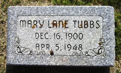
| Description | : | Ella is the daughter of Samuel & Nellie Ellen "Ellen" (Ryan)Smith. She married William Charles Lane on March 27, 1894 in De Witt, Iowa. Ella and William were the parents of eight children: ~Leo William b. January 21, 1895 d. ~Francis Louis b. January 17, 1897 d. May 27, 1953 ~Joseph R. b. December 14, 1898 d. July 1966 ~Mary Ellen b. December 16, 1900 d. April 5, 1948 ~Myrtle D. b. January 24, 1903 d. April 1976 ~Charles Edward b. July 19, 1905 d. July 20, 1916 ~Alice Theresa b. May 20, 1908 d. ~Florence Corrine b. December 30,... Read More |
frequently asked questions (FAQ):
-
Where is Ella Mae Smith Lane's memorial?
Ella Mae Smith Lane's memorial is located at: Saint Patrick's Cemetery, Delmar, Clinton County, USA.
-
When did Ella Mae Smith Lane death?
Ella Mae Smith Lane death on 1912 in Clinton County, Iowa, USA
-
Where are the coordinates of the Ella Mae Smith Lane's memorial?
Latitude: 42.0036011
Longitude: -90.6149979
Family Members:
Parent
Spouse
Siblings
Children
Flowers:
Nearby Cemetories:
1. Saint Patrick's Cemetery
Delmar, Clinton County, USA
Coordinate: 42.0036011, -90.6149979
2. Evergreen Cemetery
Delmar, Clinton County, USA
Coordinate: 41.9897003, -90.6057968
3. Union Cemetery
Brookfield Township, Clinton County, USA
Coordinate: 42.0182991, -90.6694031
4. Rathbun Cemetery
Maquoketa, Jackson County, USA
Coordinate: 42.0402000, -90.5570000
5. Bloomfield Cemetery
Clinton County, USA
Coordinate: 41.9458008, -90.6194000
6. Sacred Heart Cemetery
Maquoketa, Jackson County, USA
Coordinate: 42.0583496, -90.6617966
7. Mount Hope Cemetery
Maquoketa, Jackson County, USA
Coordinate: 42.0615616, -90.6619720
8. Immaculate Conception Cemetery
Petersville, Clinton County, USA
Coordinate: 41.9663000, -90.5332000
9. Codfish Hollow Cemetery
Maquoketa, Jackson County, USA
Coordinate: 42.0727997, -90.5793991
10. Oakview Cemetery
Welton, Clinton County, USA
Coordinate: 41.9197930, -90.6031520
11. Union Center Cemetery
Maquoketa, Jackson County, USA
Coordinate: 42.0546989, -90.5246964
12. Elwood Cemetery
Elwood, Clinton County, USA
Coordinate: 41.9935989, -90.7307968
13. Bridgeport Cemetery
Maquoketa, Jackson County, USA
Coordinate: 42.0906000, -90.6267000
14. Pine Hill Cemetery
Bliedorn, Clinton County, USA
Coordinate: 41.9309300, -90.6836500
15. Seventh Day Baptist Cemetery
Welton, Clinton County, USA
Coordinate: 41.9130000, -90.6017000
16. Goddard Cemetery
Maquoketa, Jackson County, USA
Coordinate: 42.0391998, -90.7335968
17. Saint Columbkille Cemetery
Bliedorn, Clinton County, USA
Coordinate: 41.9337330, -90.7039300
18. Saint Joseph Cemetery
Clinton County, USA
Coordinate: 42.0158100, -90.4688100
19. McClure Cemetery
Charlotte, Clinton County, USA
Coordinate: 41.9888992, -90.4669037
20. Assumption Catholic Cemetery
Charlotte, Clinton County, USA
Coordinate: 41.9668000, -90.4695000
21. Buckhorn Waterford Cemetery
Buckhorn, Jackson County, USA
Coordinate: 42.0607986, -90.7517014
22. Busch Cemetery
Clinton County, USA
Coordinate: 41.9996986, -90.7818985
23. Summer Hill Cemetery
Spragueville, Jackson County, USA
Coordinate: 42.0556000, -90.4629000
24. Walrod Family Farm Cemetery
Welton, Clinton County, USA
Coordinate: 41.8805822, -90.5779145


