

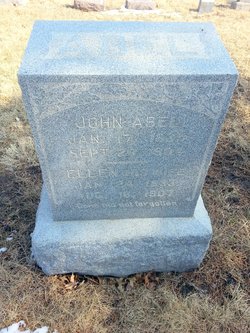
Ellen Dick Abel
| Birth | : | 24 Jan 1833 Pulaski County, Kentucky, USA |
| Death | : | 16 Aug 1907 Holton, Jackson County, Kansas, USA |
| Burial | : | Kingston Lawn Cemetery, Kingston, Kingborough Council, Australia |
| Coordinate | : | -42.9742220, 147.2829020 |
| Plot | : | Section 4 (west), Block 104, Lot 6 |
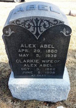
| Description | : | Mrs. Ellen Dick Abel was born in Pluska county, Kentucky, Jan. 24, 1833. She was married to John Abel in Camden Point, Platte county, Mo. She moved to Kansas in 1861. They had seven children all of whom died in infancy except one son, Alex Abel. Her husband died three years ago and she has made her home with her son, Alex Abel .... A member of the Christian church at Circleville. She was 74 years old and leaves one son and three grandchildren. The out of town people who attended the services were: J. M. Abel, of Topeka; Mrs.... Read More |
frequently asked questions (FAQ):
-
Where is Ellen Dick Abel's memorial?
Ellen Dick Abel's memorial is located at: Kingston Lawn Cemetery, Kingston, Kingborough Council, Australia.
-
When did Ellen Dick Abel death?
Ellen Dick Abel death on 16 Aug 1907 in Holton, Jackson County, Kansas, USA
-
Where are the coordinates of the Ellen Dick Abel's memorial?
Latitude: -42.9742220
Longitude: 147.2829020
Flowers:


Nearby Cemetories:
1. Kingston Lawn Cemetery
Kingston, Kingborough Council, Australia
Coordinate: -42.9742220, 147.2829020
2. Settlers’ Park Cemetery
Kingston, Kingborough Council, Australia
Coordinate: -42.9758830, 147.3054500
3. Saint Clements Anglican Cemetery
Kingston, Kingborough Council, Australia
Coordinate: -42.9754830, 147.3122690
4. Kingston Roman Catholic Cemetery
Kingston, Kingborough Council, Australia
Coordinate: -42.9763590, 147.3134030
5. North West Bay Cemetery
Margate, Kingborough Council, Australia
Coordinate: -43.0185480, 147.2540420
6. All Saints Anglican Cemetery
Margate, Kingborough Council, Australia
Coordinate: -43.0286810, 147.2630270
7. Saint Luke's Anglican Cemetery
Longley, Kingborough Council, Australia
Coordinate: -42.9751200, 147.1911800
8. Queenborough Cemetery
Sandy Bay, Hobart City, Australia
Coordinate: -42.9048420, 147.3313140
9. St. George's Burial Ground
Battery Point, Hobart City, Australia
Coordinate: -42.8915314, 147.3267267
10. St George Anglican Church Cemetery
Battery Point, Hobart City, Australia
Coordinate: -42.8914380, 147.3324820
11. Anglesea Barracks
Hobart, Hobart City, Australia
Coordinate: -42.8887860, 147.3242570
12. St. David's Park
Hobart, Hobart City, Australia
Coordinate: -42.8858767, 147.3285323
13. Davey Street Congregational Cemetery
Hobart, Hobart City, Australia
Coordinate: -42.8856150, 147.3278940
14. Snug Cemetery
Snug, Kingborough Council, Australia
Coordinate: -43.0673650, 147.2545440
15. St Mary’s Cathedral
Hobart, Hobart City, Australia
Coordinate: -42.8806220, 147.3191180
16. Harrington Street Cemetery
Hobart, Hobart City, Australia
Coordinate: -42.8801400, 147.3175940
17. Hobart Wesleyan Cemetery
Hobart, Hobart City, Australia
Coordinate: -42.8787920, 147.3104430
18. Lower Longley Methodist Cemetery
Longley Lower, Huon Valley Council, Australia
Coordinate: -42.9751080, 147.1477740
19. Friends' Park
Hobart, Hobart City, Australia
Coordinate: -42.8767052, 147.3080292
20. Saint Andrews Presbyterian Cemetery
Hobart, Hobart City, Australia
Coordinate: -42.8773519, 147.3213763
21. St. Barnabas Anglican Church Cemetery
South Arm, Clarence City, Australia
Coordinate: -43.0156858, 147.4160853
22. Saint Marks Anglican Cemetery
Bellerive, Clarence City, Australia
Coordinate: -42.8774700, 147.3691800
23. St John’s Anglican Church Cemetery
New Town, Hobart City, Australia
Coordinate: -42.8550230, 147.2969180
24. New Town Congregational Cemetery
New Town, Hobart City, Australia
Coordinate: -42.8545680, 147.3026230