
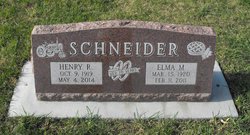
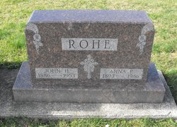
Elma Margaret Rohe Schneider
| Birth | : | 15 Mar 1920 |
| Death | : | 11 Feb 2011 |
| Burial | : | Sacred Heart Cemetery, Templeton, Carroll County, USA |
| Coordinate | : | 41.9138746, -94.9460994 |
| Description | : | Elma Margaret, daughter of John and Anna (Kemper) Rohe was born on March 15, 1920 on the family's farm near Templeton, Iowa. She attended school at Sacred Heart in Templeton. After she completed her schooling, Elma remained at home to help the family on the farm. Elma was united in marriage with Henry Schneider on January 21, 1941 at Sacred Heart Church in Templeton and the couple made their home on Elma's family farm place. There, Elma was very active in the farming operation. Elma was a wonderful cook and baker and in her free time she enjoyed playing bingo... Read More |
frequently asked questions (FAQ):
-
Where is Elma Margaret Rohe Schneider's memorial?
Elma Margaret Rohe Schneider's memorial is located at: Sacred Heart Cemetery, Templeton, Carroll County, USA.
-
When did Elma Margaret Rohe Schneider death?
Elma Margaret Rohe Schneider death on 11 Feb 2011 in
-
Where are the coordinates of the Elma Margaret Rohe Schneider's memorial?
Latitude: 41.9138746
Longitude: -94.9460994
Family Members:
Parent

Spouse
Flowers:


Nearby Cemetories:
1. Sacred Heart Cemetery
Templeton, Carroll County, USA
Coordinate: 41.9138746, -94.9460994
2. Elba Cemetery
Templeton, Carroll County, USA
Coordinate: 41.9068985, -94.9131012
3. Sacred Heart Cemetery
Manning, Carroll County, USA
Coordinate: 41.9132500, -95.0540000
4. Gray Cemetery
Gray, Audubon County, USA
Coordinate: 41.8414001, -94.9946976
5. Manning Cemetery
Manning, Carroll County, USA
Coordinate: 41.8990000, -95.0620000
6. Holy Angels Cemetery
Carroll County, USA
Coordinate: 42.0014000, -94.9141998
7. Cameron Cemetery
Audubon County, USA
Coordinate: 41.8236008, -94.9167023
8. Dedham Cemetery
Dedham, Carroll County, USA
Coordinate: 41.8993988, -94.8225021
9. Saint Josephs Cemetery
Dedham, Carroll County, USA
Coordinate: 41.8993988, -94.8210983
10. Saint Augustine Cemetery
Halbur, Carroll County, USA
Coordinate: 42.0066986, -94.9744034
11. Lincoln Township Cemetery
Gray, Audubon County, USA
Coordinate: 41.8198130, -95.0154970
12. Saint Marys Catholic Cemetery
Willey, Carroll County, USA
Coordinate: 41.9783363, -94.8212204
13. Iowa Township Cemetery
Aspinwall, Crawford County, USA
Coordinate: 41.9216995, -95.1113968
14. McCurdy Cemetery
Carroll County, USA
Coordinate: 41.9403000, -94.7649994
15. Viola Center Cemetery
Viola Center, Audubon County, USA
Coordinate: 41.8236008, -94.8016968
16. Old Carrollton Cemetery
Carrollton, Carroll County, USA
Coordinate: 41.9233017, -94.7403030
17. Mount Olivet Cemetery
Carroll, Carroll County, USA
Coordinate: 42.0536340, -94.8595510
18. Carroll City Cemetery
Carroll, Carroll County, USA
Coordinate: 42.0560963, -94.8599856
19. Hayes Township Cemetery
Westside, Crawford County, USA
Coordinate: 42.0083199, -95.1216583
20. Luccocks Grove Cemetery
Audubon County, USA
Coordinate: 41.7619019, -94.8653030
21. Douglas Township Cemetery
Audubon County, USA
Coordinate: 41.7611008, -95.0282974
22. Oak Hill Cemetery
Coon Rapids, Carroll County, USA
Coordinate: 41.9053001, -94.7200012
23. Westside Cemetery
Westside, Crawford County, USA
Coordinate: 42.0602989, -95.0922012
24. Saint Francis Cemetery
Maple River, Carroll County, USA
Coordinate: 42.0969009, -94.9372025