
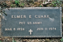
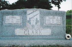
Elmer Emanuel Clark
| Birth | : | 8 Mar 1894 Myrtle, Oregon County, Missouri, USA |
| Death | : | 11 Jun 1974 Thayer, Oregon County, Missouri, USA |
| Burial | : | Saint Anthony's Roman Catholic Cemetery, Glace Bay, Cape Breton County, Canada |
| Coordinate | : | 46.1811840, -59.9681830 |
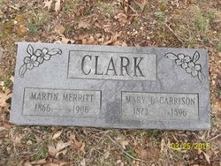
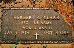
| Description | : | Elmer Emanuel Clark, son of the late Martin Clark and Mary (Garrison) Clark, was born March 8, 1894 in Myrtle, MO and departed this life June 11, 1974 at his home in Thayer, MO, at the age of 80 years, 3 months, and 3 days. He was united in marriage to Ethel Freeman on August 11, 1921 in Alton, MO and to this union five children were born. His parents, two brothers, and one sister preceded him in death. He is survived by his wife, Ethel, of the home; three sons, Herbert "Herb" Clark of Kokomo, IN; Leon Clark of Kokomo, IN; and... Read More |
frequently asked questions (FAQ):
-
Where is Elmer Emanuel Clark's memorial?
Elmer Emanuel Clark's memorial is located at: Saint Anthony's Roman Catholic Cemetery, Glace Bay, Cape Breton County, Canada.
-
When did Elmer Emanuel Clark death?
Elmer Emanuel Clark death on 11 Jun 1974 in Thayer, Oregon County, Missouri, USA
-
Where are the coordinates of the Elmer Emanuel Clark's memorial?
Latitude: 46.1811840
Longitude: -59.9681830
Family Members:
Parent

Spouse

Siblings
Children


Nearby Cemetories:
1. Saint Anthony's Roman Catholic Cemetery
Glace Bay, Cape Breton County, Canada
Coordinate: 46.1811840, -59.9681830
2. Greenwood Cemetery
Glace Bay, Cape Breton County, Canada
Coordinate: 46.1827100, -59.9741500
3. Saint Mary's Anglican Cemetery
Glace Bay, Cape Breton County, Canada
Coordinate: 46.1736667, -59.9582167
4. King Edward Street Pioneer Cemetery
Glace Bay, Cape Breton County, Canada
Coordinate: 46.1994530, -59.9868110
5. Holy Cross Catholic Cemetery
Glace Bay, Cape Breton County, Canada
Coordinate: 46.2043700, -59.9759500
6. Saint Anne's Roman Catholic Cemetery
Glace Bay, Cape Breton County, Canada
Coordinate: 46.2044460, -59.9771370
7. Calvary Cemetery
Bridgeport, Cape Breton County, Canada
Coordinate: 46.2100700, -60.0008800
8. St. Luke's Anglican Cemetery
Port Caledonia, Cape Breton County, Canada
Coordinate: 46.1796000, -59.9090600
9. Chalmers Cemetery
Dominion, Cape Breton County, Canada
Coordinate: 46.2184100, -60.0033300
10. Saint Gregory's Cemetery
Donkin, Cape Breton County, Canada
Coordinate: 46.1802830, -59.9028050
11. St. Eugene's Roman Catholic Cemetery
Dominion, Cape Breton County, Canada
Coordinate: 46.2136111, -60.0195960
12. Saint Luke's United Church Cemetery
Donkin, Cape Breton County, Canada
Coordinate: 46.1814570, -59.8742650
13. Forest Haven Memorial Gardens
Sydney, Cape Breton County, Canada
Coordinate: 46.1744200, -60.0704100
14. St. Josephs Cemetery
Lingan, Cape Breton County, Canada
Coordinate: 46.2324320, -60.0462330
15. Black Brook Cemetery
Port Morien, Cape Breton County, Canada
Coordinate: 46.1361600, -59.8723600
16. St. Mary's Roman Catholic Cemetery
Port Morien, Cape Breton County, Canada
Coordinate: 46.1100900, -59.9030100
17. Maclean Cemetery
Cape Breton County, Canada
Coordinate: 46.0936580, -60.0210160
18. Mount Carmel Catholic Cemetery
New Waterford, Cape Breton County, Canada
Coordinate: 46.2401600, -60.0825800
19. Saint Alfonsus Cemetery
Cape Breton, Cape Breton County, Canada
Coordinate: 46.1413340, -60.1023430
20. Saint Michael's Cemetery
River Ryan, Cape Breton County, Canada
Coordinate: 46.2334706, -60.0950468
21. Saint Michael's Cemetery
Scotchtown, Cape Breton County, Canada
Coordinate: 46.2336800, -60.0949100
22. Christ Church Anglican Cemetery
South Head, Cape Breton County, Canada
Coordinate: 46.0964300, -59.8812400
23. Union Grove Cemetery
Scotchtown, Cape Breton County, Canada
Coordinate: 46.2368100, -60.1007200
24. All Saints Anglican Cemetery
New Waterford, Cape Breton County, Canada
Coordinate: 46.2557300, -60.0855800