
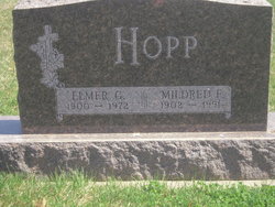
Elmer G Hopp
| Birth | : | 26 Oct 1900 |
| Death | : | Dec 1972 Cook, Johnson County, Nebraska, USA |
| Burial | : | Saint Josephs Cemetery, Belding, Ionia County, USA |
| Coordinate | : | 43.0814018, -85.2275009 |
| Description | : | Elmer was the son of Charles & Caroline (Mannschreck) Hopp. His siblings were: Arnold, Charles Jr, Harold, and Ralph. Elmer was married to Mildred and they had a daughter Bernice. |
frequently asked questions (FAQ):
-
Where is Elmer G Hopp's memorial?
Elmer G Hopp's memorial is located at: Saint Josephs Cemetery, Belding, Ionia County, USA.
-
When did Elmer G Hopp death?
Elmer G Hopp death on Dec 1972 in Cook, Johnson County, Nebraska, USA
-
Where are the coordinates of the Elmer G Hopp's memorial?
Latitude: 43.0814018
Longitude: -85.2275009
Family Members:
Parent

Spouse

Children
Flowers:


Nearby Cemetories:
1. Saint Josephs Cemetery
Belding, Ionia County, USA
Coordinate: 43.0814018, -85.2275009
2. River Ridge Cemetery
Belding, Ionia County, USA
Coordinate: 43.0806007, -85.2294006
3. Old Belding Cemetery
Belding, Ionia County, USA
Coordinate: 43.0887220, -85.2234690
4. Otisco Cemetery
Belding, Ionia County, USA
Coordinate: 43.0988998, -85.2636032
5. Smyrna Cemetery
Smyrna, Ionia County, USA
Coordinate: 43.0612380, -85.2626290
6. Greene Cemetery
Belding, Ionia County, USA
Coordinate: 43.0852509, -85.1739578
7. Rest Haven Memory Gardens
Belding, Ionia County, USA
Coordinate: 43.1138992, -85.2613983
8. Saint Marys Catholic Cemetery
Smyrna, Ionia County, USA
Coordinate: 43.0374420, -85.2530800
9. Orleans Township Cemetery
Orleans, Ionia County, USA
Coordinate: 43.0777670, -85.1357170
10. Greenop Memorial Cemetery
Orleans, Ionia County, USA
Coordinate: 43.0778008, -85.1346970
11. Mason Cemetery
Grattan Township, Kent County, USA
Coordinate: 43.0611000, -85.3321991
12. Ashley Cemetery
Grattan Township, Kent County, USA
Coordinate: 43.1149560, -85.3329510
13. Eureka Township Cemetery
Greenville, Montcalm County, USA
Coordinate: 43.1622500, -85.2603000
14. Fairplains Cemetery
Greenville, Montcalm County, USA
Coordinate: 43.1561400, -85.1722400
15. Forest Home Cemetery
Greenville, Montcalm County, USA
Coordinate: 43.1638985, -85.2613983
16. Marble Cemetery
Saranac, Ionia County, USA
Coordinate: 43.0017014, -85.2731018
17. Easton Cemetery
Easton Township, Ionia County, USA
Coordinate: 43.0031013, -85.1727982
18. Saint Paul Episcopal Church Columbarium
Greenville, Montcalm County, USA
Coordinate: 43.1785420, -85.2517710
19. First Congregational Chapel Columbarium
Greenville, Montcalm County, USA
Coordinate: 43.1787370, -85.2527370
20. First United Methodist Church Columbarium
Greenville, Montcalm County, USA
Coordinate: 43.1787690, -85.2550860
21. Clear Lake Cemetery
Fenwick, Montcalm County, USA
Coordinate: 43.1264000, -85.0943985
22. Alton Cemetery
Lowell, Kent County, USA
Coordinate: 43.0169440, -85.3505560
23. Higbee Cemetery
Orleans Township, Ionia County, USA
Coordinate: 43.0382996, -85.0868988
24. Saint Charles Catholic Cemetery
Greenville, Montcalm County, USA
Coordinate: 43.1889000, -85.2733002