Elmer Wilhelm Carl Seeland
| Birth | : | 16 Jul 1894 Farmersburg, Clayton County, Iowa, USA |
| Death | : | 24 Jul 1960 Iowa City, Johnson County, Iowa, USA |
| Burial | : | Dawn Valley Memorial Park, Bloomington, Hennepin County, USA |
| Coordinate | : | 44.8241997, -93.3807983 |
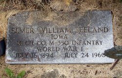
| Inscription | : | Elmer William Seeland Iowa Mech Co M 350 Infantry World War I July 16 1894 - July 24 1960 |
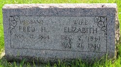
| Description | : | Father: Friedrich Seeland b. 17 Nov 1864 in Mecklenburg-Schwerin, Germany d. 8 May 1944 in Rochester, Olmsted, Minnesota Mother: Marie Elizabeth Gottschalk b. 10 Jan 1869 in Postville, Allamakee, Iowa d. 30 Jul 1901 in Farmersburg, Clayton, Iowa. Extract from the 1900 Census: Name: Elmer Seeland Age at last birthday: 5 Date of birth: Jul 1894 Birthplace: Iowa Sex: male Race: white Relationship to head-of-house: son Parents: Fred and Mary Seeland, ages 33 and 30 Home in 1900: Farmersburg, Clayton, Iowa Marital status: single Able to read, write and speak English: yes Father's birthplace: Germany Mother's birthplace: Iowa Father's occupation: barkeeper Siblings living at home: Nora (age 8) and Milda (2) Census place: Farmersburg, Clayton, Iowa; Roll: T623... Read More |
frequently asked questions (FAQ):
-
Where is Elmer Wilhelm Carl Seeland's memorial?
Elmer Wilhelm Carl Seeland's memorial is located at: Dawn Valley Memorial Park, Bloomington, Hennepin County, USA.
-
When did Elmer Wilhelm Carl Seeland death?
Elmer Wilhelm Carl Seeland death on 24 Jul 1960 in Iowa City, Johnson County, Iowa, USA
-
Where are the coordinates of the Elmer Wilhelm Carl Seeland's memorial?
Latitude: 44.8241997
Longitude: -93.3807983
Family Members:
Parent
Spouse
Flowers:
Nearby Cemetories:
1. Dawn Valley Memorial Park
Bloomington, Hennepin County, USA
Coordinate: 44.8241997, -93.3807983
2. Hillside Crematory
Bloomington, Hennepin County, USA
Coordinate: 44.8232710, -93.3803470
3. Church of Saint Edward Memorial Garden
Bloomington, Hennepin County, USA
Coordinate: 44.8323000, -93.3576000
4. Bloomington Ferry Cemetery (Defunct)
Bloomington, Hennepin County, USA
Coordinate: 44.8017300, -93.3884300
5. Pleasant Hill Cemetery
Eden Prairie, Hennepin County, USA
Coordinate: 44.8307991, -93.4344025
6. Saint Stephen Lutheran Columbarium
Bloomington, Hennepin County, USA
Coordinate: 44.8509380, -93.3297870
7. Oak Grove Presbyterian Church Columbarium
Bloomington, Hennepin County, USA
Coordinate: 44.8194490, -93.3084200
8. Christ Presbyterian Church Memorial Prayer Garden
Edina, Hennepin County, USA
Coordinate: 44.8768082, -93.3487625
9. Saint Andrew Lutheran Church Columbarium
Eden Prairie, Hennepin County, USA
Coordinate: 44.8600420, -93.4501790
10. Glendale Cemetery
Savage, Scott County, USA
Coordinate: 44.7606010, -93.3889008
11. Bloomington Cemetery
Bloomington, Hennepin County, USA
Coordinate: 44.8153000, -93.2893982
12. United Hebrew Brotherhood Cemetery
Richfield, Hennepin County, USA
Coordinate: 44.8750000, -93.3131027
13. Saint John the Baptist Catholic Cemetery
Burnsville, Dakota County, USA
Coordinate: 44.7645730, -93.3258040
14. B'Nai Emet Cemetery
Richfield, Hennepin County, USA
Coordinate: 44.8740510, -93.3085120
15. Minneapolis Jewish Cemetery
Richfield, Hennepin County, USA
Coordinate: 44.8753014, -93.3099976
16. Gemelus Chesed Cemetery
Richfield, Hennepin County, USA
Coordinate: 44.8752750, -93.3087220
17. Eden Prairie Cemetery
Eden Prairie, Hennepin County, USA
Coordinate: 44.8429985, -93.4820023
18. Saint Margaret Cemetery
Minnetonka, Hennepin County, USA
Coordinate: 44.8986015, -93.4191971
19. Shady Oak Lake Cemetery
Minnetonka, Hennepin County, USA
Coordinate: 44.9014015, -93.4257965
20. Calvary Catholic Cemetery
Shakopee, Scott County, USA
Coordinate: 44.7835000, -93.4845000
21. Immanuel Lutheran Columbarium
Eden Prairie, Hennepin County, USA
Coordinate: 44.8649070, -93.4869150
22. Adath Yeshurun Cemetery
Edina, Hennepin County, USA
Coordinate: 44.9015007, -93.3283310
23. Church of The Assumption Catholic Cemetery
Richfield, Hennepin County, USA
Coordinate: 44.8635406, -93.2725677
24. Valley Cemetery
Shakopee, Scott County, USA
Coordinate: 44.7966995, -93.4974976


