
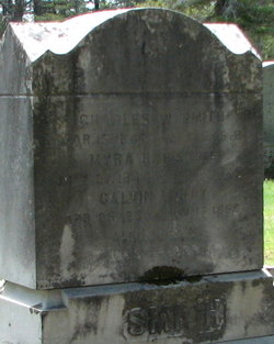
Elmira Elizabeth “Myra” Stoddard Smith
| Birth | : | 27 Jul 1844 Winchendon, Worcester County, Massachusetts, USA |
| Death | : | 1925 |
| Burial | : | Greenlawn Cemetery, Templeton, Worcester County, USA |
| Coordinate | : | 42.6124992, -72.0708008 |
| Description | : | -Dau of Alvin & Harriet Stoddard -Married: 1)on 25 Apr 1861 to Calvin Washburn Ray in Gardner, MA, widowed 2)on 08 Sep 1867 to Charles W Smith in Templeton, MA |
frequently asked questions (FAQ):
-
Where is Elmira Elizabeth “Myra” Stoddard Smith's memorial?
Elmira Elizabeth “Myra” Stoddard Smith's memorial is located at: Greenlawn Cemetery, Templeton, Worcester County, USA.
-
When did Elmira Elizabeth “Myra” Stoddard Smith death?
Elmira Elizabeth “Myra” Stoddard Smith death on 1925 in
-
Where are the coordinates of the Elmira Elizabeth “Myra” Stoddard Smith's memorial?
Latitude: 42.6124992
Longitude: -72.0708008
Family Members:
Spouse


Children

Flowers:


Nearby Cemetories:
1. Greenlawn Cemetery
Templeton, Worcester County, USA
Coordinate: 42.6124992, -72.0708008
2. New Boston Cemetery
Winchendon, Worcester County, USA
Coordinate: 42.6306000, -72.0860977
3. Saint Josephs Cemetery
Gardner, Worcester County, USA
Coordinate: 42.5922012, -72.0391998
4. Baptist Common Cemetery
Templeton, Worcester County, USA
Coordinate: 42.5808600, -72.0720740
5. Norcross Hill Cemetery
Templeton, Worcester County, USA
Coordinate: 42.5957985, -72.1110992
6. Wildwood Cemetery
Gardner, Worcester County, USA
Coordinate: 42.5896988, -72.0306015
7. Saint Johns Cemetery
Gardner, Worcester County, USA
Coordinate: 42.5875015, -72.0207977
8. Notre Dame Cemetery
Gardner, Worcester County, USA
Coordinate: 42.5849991, -72.0222015
9. Pine Grove Cemetery
Templeton, Worcester County, USA
Coordinate: 42.5625000, -72.0888977
10. Old Centre Burial Ground
Winchendon, Worcester County, USA
Coordinate: 42.6617012, -72.0366974
11. Templeton Common Burial Ground
Templeton, Worcester County, USA
Coordinate: 42.5554450, -72.0684430
12. Riverside Cemetery
Royalston, Worcester County, USA
Coordinate: 42.6302986, -72.1453018
13. Crystal Lake Cemetery
Gardner, Worcester County, USA
Coordinate: 42.5833015, -71.9957962
14. Old Burying Ground
Gardner, Worcester County, USA
Coordinate: 42.5811800, -71.9867100
15. Calvary Cemetery
Winchendon, Worcester County, USA
Coordinate: 42.6805992, -72.0318985
16. Riverside Cemetery
Winchendon, Worcester County, USA
Coordinate: 42.6805992, -72.0263977
17. Lower Cemetery
Phillipston, Worcester County, USA
Coordinate: 42.5583000, -72.1425018
18. Upper Cemetery
Phillipston, Worcester County, USA
Coordinate: 42.5512820, -72.1339770
19. Massachusetts Veterans Memorial Cemetery
Winchendon, Worcester County, USA
Coordinate: 42.6851300, -72.0185200
20. Green Bower Cemetery
Gardner, Worcester County, USA
Coordinate: 42.5555992, -71.9860992
21. Nahum Greene Gravesite
Royalston, Worcester County, USA
Coordinate: 42.6545700, -72.1712900
22. South Cemetery
Phillipston, Worcester County, USA
Coordinate: 42.5318985, -72.1267014
23. Lawrence Brook Cemetery
Royalston, Worcester County, USA
Coordinate: 42.6693993, -72.1707993
24. Jonas Alliene Cemetery
Royalston, Worcester County, USA
Coordinate: 42.6748790, -72.1656520