
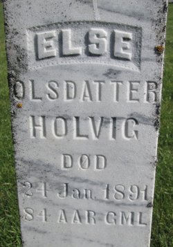
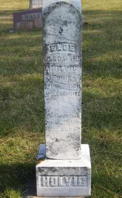
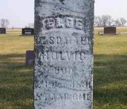
Else Olsdatter Holvig
| Birth | : | 1807 Gloppen, Gloppen kommune, Sogn og Fjordane fylke, Norway |
| Death | : | 24 Jan 1891 Lake County, South Dakota, USA |
| Burial | : | Winfield Bible Chapel Cemetery, Winfield, Carroll County, USA |
| Coordinate | : | 39.4250400, -77.0508500 |
| Description | : | Else Olsdatter was born in 1807 to Ole Borresen and Marthe Steffensdatter in Sandene, Gloppen, Sogn Og Fjordane, Norway. She was christened on October 18, 1807 in Gloppen Parish. She married Elling Pedersen Holvig November 12, 1831 in Gloppen, Sogn Og Fjordane, Norway. immigration: depart Bergen, Norway and arrive Quebec, Quebec, Canada 6/26/1871 on ship Argo, age 62, Else Olsdatter Holvik. She moved to Lake County, South Dakota with some of her children. She died January 24, 1891 in Lake County, SD. Children of Elling Pedersen and Else Olsdatter Holvig: Inger, Peder, Ole, Berthe, Marthe, Ole, and Eli. |
frequently asked questions (FAQ):
-
Where is Else Olsdatter Holvig's memorial?
Else Olsdatter Holvig's memorial is located at: Winfield Bible Chapel Cemetery, Winfield, Carroll County, USA.
-
When did Else Olsdatter Holvig death?
Else Olsdatter Holvig death on 24 Jan 1891 in Lake County, South Dakota, USA
-
Where are the coordinates of the Else Olsdatter Holvig's memorial?
Latitude: 39.4250400
Longitude: -77.0508500
Family Members:
Children
Flowers:


Nearby Cemetories:
1. Winfield Bible Chapel Cemetery
Winfield, Carroll County, USA
Coordinate: 39.4250400, -77.0508500
2. Pleasant Ridge Cemetery
Winfield, Carroll County, USA
Coordinate: 39.4253006, -77.0522003
3. Ebenezer United Methodist Church Cemetery
Winfield, Carroll County, USA
Coordinate: 39.4399490, -77.0548172
4. Highland View Cemetery
Winfield, Carroll County, USA
Coordinate: 39.4202995, -77.0117035
5. Brandenburg United Methodist Church Cemetery
Sykesville, Carroll County, USA
Coordinate: 39.4077988, -77.0168991
6. Cook Family Cemetery
Dorsey Crossroads, Carroll County, USA
Coordinate: 39.4355888, -77.0064240
7. Morgan Chapel United Methodist Church Cemetery
Woodbine, Carroll County, USA
Coordinate: 39.3871700, -77.0554700
8. Davis Family Cemetery #1
Mount Airy, Carroll County, USA
Coordinate: 39.4100037, -77.0983200
9. Taylorsville United Methodist Church Cemetery
Taylorsville, Carroll County, USA
Coordinate: 39.4539400, -77.0892300
10. Mount Olive United Methodist Church Cemetery
Mount Airy, Carroll County, USA
Coordinate: 39.4032000, -77.0986000
11. White Rock United Methodist Church Cemetery
Sykesville, Carroll County, USA
Coordinate: 39.4017300, -76.9993600
12. Harmony Grove Cemetery
Carroll County, USA
Coordinate: 39.4481010, -76.9910965
13. Salem United Methodist Church Cemetery
Westminster, Carroll County, USA
Coordinate: 39.4775009, -77.0297012
14. Bethany Cemetery
Taylorsville, Carroll County, USA
Coordinate: 39.4636002, -77.1061020
15. Evans Family Cemetery
Dennings, Carroll County, USA
Coordinate: 39.4817009, -77.0655975
16. Bethesda United Methodist Church Cemetery
Sykesville, Carroll County, USA
Coordinate: 39.4556007, -76.9832993
17. Harrisville Chapel Cemetery
Mount Airy, Carroll County, USA
Coordinate: 39.4089640, -77.1285130
18. Fair View Cemetery
Carroll County, USA
Coordinate: 39.4625015, -77.1172028
19. Gosnell Haines Family Cemetery
Buffalo Hills, Frederick County, USA
Coordinate: 39.4602700, -77.1197200
20. Davis - Waters Family Cemetery
Mount Airy, Carroll County, USA
Coordinate: 39.3744812, -77.1089172
21. Saint James United Methodist Church Cemetery
Dennings, Carroll County, USA
Coordinate: 39.4917200, -77.0733200
22. Wesley Chapel Cemetery
Eldersburg, Carroll County, USA
Coordinate: 39.4070030, -76.9624040
23. Wesley Freedom United Methodist Church Cemetery
Eldersburg, Carroll County, USA
Coordinate: 39.4056015, -76.9608002
24. Johnsville United Methodist Church Cemetery
Eldersburg, Carroll County, USA
Coordinate: 39.4136009, -76.9569016