
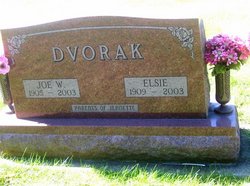
Elsie Cernin Dvorak
| Birth | : | 18 Jul 1909 Vining, Tama County, Iowa, USA |
| Death | : | 20 Oct 2003 Keystone, Benton County, Iowa, USA |
| Burial | : | Union Hill Cemetery, Brandsville, Howell County, USA |
| Coordinate | : | 36.5256341, -91.4746829 |
| Description | : | The Belle Plaine Union, Wednesday, October 22, 2003 page 4 Funeral services for Elsie Dvorak, 94, Keystone, were Monday, October 20, 2003, at Hrabak Funeral Home, Belle Plaine, with Rev. David Crow officiating. Burial was in National Cemetery, Vining. Mrs. Dvorak died Thursday, October 16, 2003, at Keystone Care Center. Pallbearers were Norman Dvorak, Tom Dvorak, Richard Cernin, Wayne Silhanek, David Schoeberl and James Schoeberl. Music was provided by organist, Mrs. Jane Hrabak, with selections of "Rock of Ages", "How Great Thou Art", "Amazing Grace", "Wind Beneath My Wing" and "In the Garden". Elsie Dvorak was born July 18,... Read More |
frequently asked questions (FAQ):
-
Where is Elsie Cernin Dvorak's memorial?
Elsie Cernin Dvorak's memorial is located at: Union Hill Cemetery, Brandsville, Howell County, USA.
-
When did Elsie Cernin Dvorak death?
Elsie Cernin Dvorak death on 20 Oct 2003 in Keystone, Benton County, Iowa, USA
-
Where are the coordinates of the Elsie Cernin Dvorak's memorial?
Latitude: 36.5256341
Longitude: -91.4746829
Family Members:
Spouse

Flowers:


Nearby Cemetories:
1. Union Hill Cemetery
Brandsville, Howell County, USA
Coordinate: 36.5256341, -91.4746829
2. Jeff Cemetery
Jeff, Oregon County, USA
Coordinate: 36.5256166, -91.4746129
3. Davis Cemetery
Thayer, Oregon County, USA
Coordinate: 36.5339508, -91.4751358
4. Brenner Farm Cemetery
Allen Ford, Oregon County, USA
Coordinate: 36.5477000, -91.5065400
5. Ragan Cemetery
Thayer, Oregon County, USA
Coordinate: 36.5235863, -91.5213242
6. N B Allen Ford
Allen Ford, Oregon County, USA
Coordinate: 36.5411700, -91.5172900
7. Buehler Farm Cemetery
Clifton, Oregon County, USA
Coordinate: 36.5639496, -91.4845810
8. Rose Hill Cemetery
Thayer, Oregon County, USA
Coordinate: 36.5186386, -91.4263763
9. Old George Martin Farm Cemetery
Allen Ford, Oregon County, USA
Coordinate: 36.5374850, -91.5230010
10. Spring City Cemetery #2
Mammoth Spring, Fulton County, USA
Coordinate: 36.4982800, -91.5299400
11. Spring City Cemetery
Mammoth Spring, Fulton County, USA
Coordinate: 36.4983360, -91.5308040
12. Thayer Cemetery
Thayer, Oregon County, USA
Coordinate: 36.5152200, -91.5395100
13. Clifton Cemetery
Clifton, Oregon County, USA
Coordinate: 36.5511017, -91.5350037
14. Pleasant Ridge Cemetery
Sharp County, USA
Coordinate: 36.4876710, -91.4221830
15. Adolph Ostrom Farm Cemetery
Thayer, Oregon County, USA
Coordinate: 36.5788160, -91.4426640
16. Lindley Cemetery
Clifton, Oregon County, USA
Coordinate: 36.5820400, -91.5036200
17. Field Creek Cemetery
Mammoth Spring, Fulton County, USA
Coordinate: 36.4693985, -91.5042038
18. Old Town Church of God
Old Town, Oregon County, USA
Coordinate: 36.5004900, -91.5451800
19. Clifton Cemetery
Sloan Ford, Oregon County, USA
Coordinate: 36.5677900, -91.5329000
20. Russell Cemetery
Couch, Oregon County, USA
Coordinate: 36.5506477, -91.3991928
21. Riverside Cemetery
Mammoth Spring, Fulton County, USA
Coordinate: 36.4838982, -91.5406036
22. Bledsaw Cemetery
Thayer, Oregon County, USA
Coordinate: 36.5595741, -91.5537949
23. Bethel Cemetery #2
Fulton County, USA
Coordinate: 36.4524994, -91.4850006
24. Davis Cemetery
Fulton County, USA
Coordinate: 36.4991989, -91.5643997