
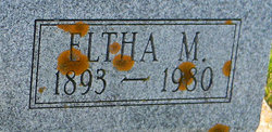
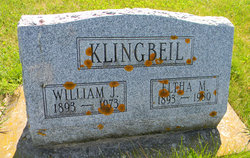
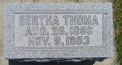
Eltha M Thoma Klingbeil
| Birth | : | 25 Jul 1893 Clayton County, Iowa, USA |
| Death | : | 7 Aug 1980 Emporia, Lyon County, Kansas, USA |
| Burial | : | Plainview Cemetery, Bladen, Webster County, USA |
| Coordinate | : | 40.2841988, -98.5858002 |
| Description | : | She was a Christian Scientist and a member of The Mother Church, The First Church of Christ Scientist, Boston, Massachusetts, founded by Mary Baker Eddy. |
frequently asked questions (FAQ):
-
Where is Eltha M Thoma Klingbeil's memorial?
Eltha M Thoma Klingbeil's memorial is located at: Plainview Cemetery, Bladen, Webster County, USA.
-
When did Eltha M Thoma Klingbeil death?
Eltha M Thoma Klingbeil death on 7 Aug 1980 in Emporia, Lyon County, Kansas, USA
-
Where are the coordinates of the Eltha M Thoma Klingbeil's memorial?
Latitude: 40.2841988
Longitude: -98.5858002
Family Members:
Parent
Spouse
Siblings
Children
Flowers:


Nearby Cemetories:
1. Plainview Cemetery
Bladen, Webster County, USA
Coordinate: 40.2841988, -98.5858002
2. East Lawn Cemetery
Bladen, Webster County, USA
Coordinate: 40.3208008, -98.5886002
3. Cloverton Cemetery
Bladen, Webster County, USA
Coordinate: 40.2989006, -98.5378036
4. Catherton Cemetery
Webster County, USA
Coordinate: 40.2421989, -98.6324997
5. Harmony Cemetery
Bladen, Webster County, USA
Coordinate: 40.3218994, -98.6605988
6. Dane Lutheran Cemetery
Cowles, Webster County, USA
Coordinate: 40.1903000, -98.5947000
7. Saint Ann Cemetery
Webster County, USA
Coordinate: 40.2914009, -98.7093964
8. Batin Cemetery
Cowles, Webster County, USA
Coordinate: 40.2299995, -98.4822006
9. Campbell Cemetery
Webster County, USA
Coordinate: 40.3064570, -98.7220340
10. New Virginia Cemetery
Webster County, USA
Coordinate: 40.1906013, -98.6678009
11. Walker Cemetery
Blue Hill, Webster County, USA
Coordinate: 40.2881012, -98.4255981
12. Koch-Cook Cemetery
Franklin County, USA
Coordinate: 40.2917700, -98.7474800
13. Logan Cemetery
Adams County, USA
Coordinate: 40.3927994, -98.6658020
14. Blue Hill Cemetery
Blue Hill, Webster County, USA
Coordinate: 40.3344002, -98.4357986
15. Trinity Lutheran Cemetery
Adams County, USA
Coordinate: 40.3516998, -98.4400024
16. Saxour Cemetery
Ayr, Adams County, USA
Coordinate: 40.3940700, -98.4867600
17. Trinity Lutheran Cemetery
Campbell, Franklin County, USA
Coordinate: 40.2625008, -98.7605972
18. Howe Cemetery
Webster County, USA
Coordinate: 40.2341730, -98.4154440
19. Morseville Cemetery
Adams County, USA
Coordinate: 40.3941994, -98.6996994
20. Norwegian Zion Lutheran Cemetery
Inavale, Webster County, USA
Coordinate: 40.1913000, -98.7255000
21. Pleasant Prairie Cemetery
Inavale, Webster County, USA
Coordinate: 40.1464005, -98.6382980
22. Cowles Cemetery
Cowles, Webster County, USA
Coordinate: 40.1755000, -98.4425000
23. Salem Cemetery
Webster County, USA
Coordinate: 40.2341995, -98.3855972
24. Roseland Mennonite Cemetery
Roseland, Adams County, USA
Coordinate: 40.4411011, -98.5164032