Elzie Lewis Hinkle
| Birth | : | 17 Nov 1916 Nebraska, USA |
| Death | : | 15 Jul 2006 Red Bluff, Tehama County, California, USA |
| Burial | : | Saint Gabriel's Cemetery, Jacquet River, Restigouche County, Canada |
| Coordinate | : | 47.9156900, -66.0165100 |
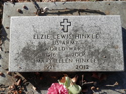
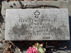
| Inscription | : | US ARMY WORLD WAR II |
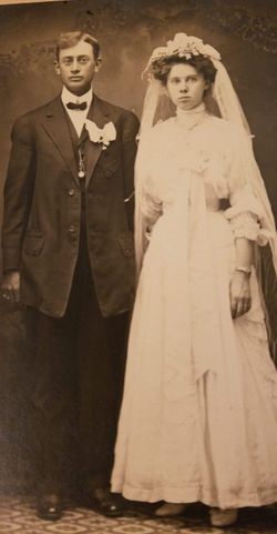
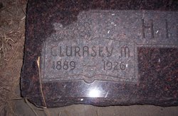
| Description | : | Elzie Lewis Hinkle, 89, of Red Bluff, died at home. He was born to Enoch and Clarisey Hinkle and moved with his family to Tehama County in 1935 from Nebraska. He served three years in the U.S. Army during World War II.He also drove log and lumber truck for his brother, Royal Hinkle and retired in 1977 from Louisiana Pacific. His hobbies were hunting, golfing, and trap shooting. Survivors include wife, Mary; sons, Melvin of Tolleson, Arizona and William of San Diego; daughter, Wanda Johnson of Jacksonville, Oregon; brothers, Clatus of Nebraska and Irvin of Red Bluff; sister, Vera Davis of... Read More |
frequently asked questions (FAQ):
-
Where is Elzie Lewis Hinkle's memorial?
Elzie Lewis Hinkle's memorial is located at: Saint Gabriel's Cemetery, Jacquet River, Restigouche County, Canada.
-
When did Elzie Lewis Hinkle death?
Elzie Lewis Hinkle death on 15 Jul 2006 in Red Bluff, Tehama County, California, USA
-
Where are the coordinates of the Elzie Lewis Hinkle's memorial?
Latitude: 47.9156900
Longitude: -66.0165100
Family Members:
Parent
Spouse
Siblings
Flowers:
Nearby Cemetories:
1. Saint Gabriel's Cemetery
Jacquet River, Restigouche County, Canada
Coordinate: 47.9156900, -66.0165100
2. The Meeting House Cemetery
Jacquet River, Restigouche County, Canada
Coordinate: 47.9179700, -66.0001400
3. St. Joseph's Cemetery
Nash Creek, Restigouche County, Canada
Coordinate: 47.9212200, -66.0814300
4. St. Maria Goretti Catholic Cemetery
Lorne, Restigouche County, Canada
Coordinate: 47.8720790, -66.1266760
5. Old Pioneer Protestant Church
Belledune River, Restigouche County, Canada
Coordinate: 47.9102427, -65.8795417
6. Our Lady of Visitation Cemetery
Benjamin River, Restigouche County, Canada
Coordinate: 47.9608470, -66.1677440
7. Saint John Evangelist RC Cemetery
Belledune, Restigouche County, Canada
Coordinate: 47.9059870, -65.8446690
8. New Mills Cemetery
New Mills, Restigouche County, Canada
Coordinate: 47.9682730, -66.1863330
9. Dalhousie Riverview Cemetery Extension
Dalhousie, Restigouche County, Canada
Coordinate: 47.9687720, -66.1871800
10. St Luke's United Cemetery
Belledune, Gloucester County, Canada
Coordinate: 47.8871900, -65.8130800
11. Saint Luke's United Cemetery
Belledune River, Restigouche County, Canada
Coordinate: 47.8784770, -65.8025750
12. Old Carleton Cemetery
Carleton, Gaspesie-Iles-de-la-Madeleine Region, Canada
Coordinate: 48.1011100, -66.1086890
13. Crypte de l'église de Carleton-sur-Mer
Carleton-sur-Mer, Gaspesie-Iles-de-la-Madeleine Region, Canada
Coordinate: 48.1016010, -66.1082120
14. Carleton-sur-Mer Cimetière du Saint Joseph
Carleton-sur-Mer, Gaspesie-Iles-de-la-Madeleine Region, Canada
Coordinate: 48.1059810, -66.1077940
15. St Francois-Xavier Cemetery
Charlo, Restigouche County, Canada
Coordinate: 48.0033690, -66.3383130
16. Cimetière (ancien) de St-Omer (Carleton-sur-Mer)
Carleton-sur-Mer, Gaspesie-Iles-de-la-Madeleine Region, Canada
Coordinate: 48.1106660, -66.2205170
17. Cimetière (nouveau) de St-Omer (Carleton-sur-Mer)
Carleton-sur-Mer, Gaspesie-Iles-de-la-Madeleine Region, Canada
Coordinate: 48.1126800, -66.2185330
18. New Carleton Cemetery
Carleton-sur-Mer, Gaspesie-Iles-de-la-Madeleine Region, Canada
Coordinate: 48.1126800, -66.2185330
19. Black Cape Cemetery
New Richmond, Gaspesie-Iles-de-la-Madeleine Region, Canada
Coordinate: 48.1265400, -65.8144010
20. Cimetière de Maria
Maria, Gaspesie-Iles-de-la-Madeleine Region, Canada
Coordinate: 48.1703009, -65.9898902
21. Cimetière de Maria (église)
Maria, Gaspesie-Iles-de-la-Madeleine Region, Canada
Coordinate: 48.1705460, -65.9901720
22. Cimetière de Maria (nouveau)
Maria, Gaspesie-Iles-de-la-Madeleine Region, Canada
Coordinate: 48.1729570, -65.9933830
23. Cimetière catholique de New-Richmond
New Richmond Centre, Gaspesie-Iles-de-la-Madeleine Region, Canada
Coordinate: 48.1612950, -65.8610350
24. Saint Andrew's United Church Cemetery
New Richmond, Gaspesie-Iles-de-la-Madeleine Region, Canada
Coordinate: 48.1670800, -65.8705860

