
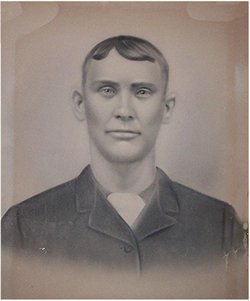
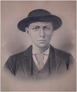
Emanuel “Manuel” Best
| Birth | : | 19 Oct 1872 Vincennes, Lee County, Iowa, USA |
| Death | : | 16 Oct 1897 Clark County, Missouri, USA |
| Burial | : | Oakland Cemetery, Vincennes, Lee County, USA |
| Coordinate | : | 40.4980600, -91.5958300 |
| Description | : | As the family story goes, Manuel's body was buried next to his brother George. That evening after the funeral someone notified Grandpa Ben that someone was seen at the cemetery digging up bodies. The family rushed over across the River from Missouri. By the time they had arrived the individuals were gone leaving nothing but Manuel's clothes. Grandpa Ben, Grandpa Dove and others sat up all the rest of the evening, well armed, in case the grave robbers would come back. |
frequently asked questions (FAQ):
-
Where is Emanuel “Manuel” Best's memorial?
Emanuel “Manuel” Best's memorial is located at: Oakland Cemetery, Vincennes, Lee County, USA.
-
When did Emanuel “Manuel” Best death?
Emanuel “Manuel” Best death on 16 Oct 1897 in Clark County, Missouri, USA
-
Where are the coordinates of the Emanuel “Manuel” Best's memorial?
Latitude: 40.4980600
Longitude: -91.5958300
Family Members:
Parent
Siblings
Flowers:


Nearby Cemetories:
1. Oakland Cemetery
Vincennes, Lee County, USA
Coordinate: 40.4980600, -91.5958300
2. Quarry Cemetery
Argyle, Lee County, USA
Coordinate: 40.5051850, -91.6010140
3. Beaird Cemetery
Clark County, USA
Coordinate: 40.4934400, -91.6178400
4. Maryville Cemetery
Marysville, Clark County, USA
Coordinate: 40.4739900, -91.5851200
5. Prairie Church Cemetery
Revere, Clark County, USA
Coordinate: 40.4831009, -91.6324997
6. Sands Cemetery
Lee County, USA
Coordinate: 40.4714012, -91.5674973
7. Abraham Wayland Family Cemetery
Dumas, Clark County, USA
Coordinate: 40.5302390, -91.6211700
8. Dumas Cemetery
Clark County, USA
Coordinate: 40.5214400, -91.6352100
9. Sand Cemetery
Saint Francisville, Clark County, USA
Coordinate: 40.4516983, -91.5625000
10. Wolf Cemetery
Saint Francisville, Clark County, USA
Coordinate: 40.4467010, -91.5725021
11. Betts Family Cemetery
Clark County, USA
Coordinate: 40.5351000, -91.6483000
12. Argyle Memorial Garden
Argyle, Lee County, USA
Coordinate: 40.5411800, -91.5374300
13. Revere Cemetery
Revere, Clark County, USA
Coordinate: 40.4981400, -91.6787900
14. New Revere Cemetery
Revere, Clark County, USA
Coordinate: 40.4996050, -91.6792350
15. Northrup Cemetery
Revere, Clark County, USA
Coordinate: 40.5000000, -91.6808014
16. Belfast Cemetery
Lee County, USA
Coordinate: 40.5529000, -91.6485000
17. Walker Cemetery
Clark County, USA
Coordinate: 40.5161018, -91.6821976
18. Waterloo Cemetery
Clark County, USA
Coordinate: 40.4523900, -91.6666600
19. String Prairie Cemetery
Donnellson, Lee County, USA
Coordinate: 40.5688000, -91.5940000
20. Ambrosia Cemetery
Montrose, Lee County, USA
Coordinate: 40.5242080, -91.5015450
21. Oak Hill Cemetery
Wayland, Clark County, USA
Coordinate: 40.4219017, -91.6057968
22. Galland Cemetery
Peaksville, Clark County, USA
Coordinate: 40.4858551, -91.6997452
23. Scandinavian Cemetery
Lee County, USA
Coordinate: 40.4737000, -91.4867800
24. Peaksville Cemetery
Peaksville, Clark County, USA
Coordinate: 40.5149994, -91.7080994