
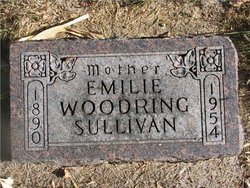
Emilie “Millie” Rueschenberg Woodring Sullivan
| Birth | : | 19 Jan 1890 Germany |
| Death | : | 27 Apr 1954 Livingston, Park County, Montana, USA |
| Burial | : | Frankfort Cemetery, Frankfort, Spink County, USA |
| Coordinate | : | 44.8784800, -98.2965200 |
| Plot | : | Blk G, Lot 28, Gr 4 |
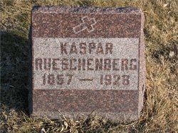
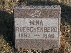
| Description | : | Emilie "Millie" (Rueschenberg) Woodring, Sullivan was born 19 Jan 1890 in the Prussian province of Westphalia, Germany to Casper J. Rueschenberg (1857-1928) and Wilhelmina (Fanenholtz) Rueschenberg (1862-1945). Aberdeen Evening News, Friday, April 30, 1954 MRS. MILLIE SULLIVAN FRANKFORT -- Funeral services for Mrs. Millie Sullivan, 64, who died at Livingston, Mont., will be held at 10 a.m. Monday at St. Ann's Catholic Church at Frankfort. Burial will be at Frankfort. Rosary will be said at 8:30 p.m. Sunday at the church. Millie Rueschenberg was born Jan. 19, 1890, in Germany. In October 1908,... Read More |
frequently asked questions (FAQ):
-
Where is Emilie “Millie” Rueschenberg Woodring Sullivan's memorial?
Emilie “Millie” Rueschenberg Woodring Sullivan's memorial is located at: Frankfort Cemetery, Frankfort, Spink County, USA.
-
When did Emilie “Millie” Rueschenberg Woodring Sullivan death?
Emilie “Millie” Rueschenberg Woodring Sullivan death on 27 Apr 1954 in Livingston, Park County, Montana, USA
-
Where are the coordinates of the Emilie “Millie” Rueschenberg Woodring Sullivan's memorial?
Latitude: 44.8784800
Longitude: -98.2965200
Family Members:
Parent
Spouse
Siblings
Children
Flowers:


Nearby Cemetories:
1. Frankfort Cemetery
Frankfort, Spink County, USA
Coordinate: 44.8784800, -98.2965200
2. Saint Ann Cemetery
Frankfort, Spink County, USA
Coordinate: 44.8821983, -98.3028030
3. Poor Farm Cemetery
Frankfort, Spink County, USA
Coordinate: 44.8836350, -98.3591071
4. Guttenberg Cemetery
Spink County, USA
Coordinate: 44.8205986, -98.2972031
5. Glendale Colony Cemetery
Spink County, USA
Coordinate: 44.7999900, -98.2856600
6. Irving Cemetery
Doland, Spink County, USA
Coordinate: 44.7751500, -98.2203600
7. Clifton Cemetery
Clifton Township, Spink County, USA
Coordinate: 45.0106010, -98.3197021
8. Spink Colony Cemetery
Spink Colony, Spink County, USA
Coordinate: 44.7440800, -98.2923800
9. Crandon Cemetery
Spink County, USA
Coordinate: 44.7825012, -98.4436035
10. Ebenezer Cemetery
Doland, Spink County, USA
Coordinate: 44.7602997, -98.1797028
11. Graceland Cemetery
Tulare, Spink County, USA
Coordinate: 44.7481003, -98.3861008
12. Rose Hill Cemetery
Doland, Spink County, USA
Coordinate: 44.7484600, -98.1993600
13. Irving Cemetery
Spink County, USA
Coordinate: 44.7486000, -98.1986008
14. Doland Cemetery
Doland, Spink County, USA
Coordinate: 44.8993988, -98.0828018
15. Saint Bernard Cemetery
Redfield, Spink County, USA
Coordinate: 44.8857994, -98.5139008
16. Greenlawn Cemetery
Redfield, Spink County, USA
Coordinate: 44.8857994, -98.5164032
17. South Dakota Developmental Center Cemetery
Spink County, USA
Coordinate: 44.8880120, -98.5234880
18. Hillestad Cemetery
Spink County, USA
Coordinate: 44.6944008, -98.2596970
19. Tulare Cemetery
Tulare, Spink County, USA
Coordinate: 44.7486000, -98.4922028
20. Ashton Cemetery
Ashton, Spink County, USA
Coordinate: 44.9914017, -98.5224991
21. Emmanuel Mennonite Cemetery
Spink County, USA
Coordinate: 44.7041300, -98.1207900
22. Hillside Colony Cemetery
Hillside Colony, Spink County, USA
Coordinate: 44.7404700, -98.0486100
23. Saint Josephs Cemetery
Turton, Spink County, USA
Coordinate: 45.0479660, -98.0899500
24. Sunnyside Cemetery
Turton, Spink County, USA
Coordinate: 45.0472600, -98.0849800