
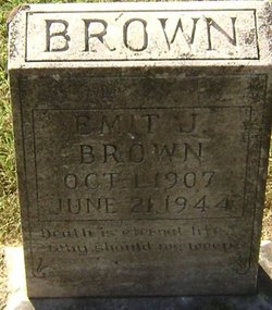
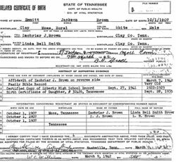

Emit Jackson Brown
| Birth | : | 1 Oct 1907 Moss, Clay County, Tennessee, USA |
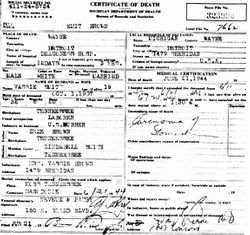
| Death | : | 21 Jun 1944 Detroit, Wayne County, Michigan, USA |
| Burial | : | Macedonia Cemetery, Moss, Clay County, USA |
| Coordinate | : | 36.5643997, -85.6110992 |
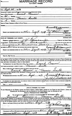
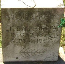
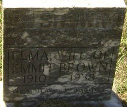
| Description | : | Emit or Emmitt was born in Clay Co., Tn near Moss on October 1, 1907. He was the son of Zeke and Linda Belle (Smith) Brown. He married Elma Cherry in Clay Co., TN on December 15, 1929. After his first wife's death he married Vassie Smith in Clay Co., TN on September 25, 1940. Emit died in Detroit, MI. He was married to Vassie and working as a laborer for US Rubber at his death. |
frequently asked questions (FAQ):
-
Where is Emit Jackson Brown's memorial?
Emit Jackson Brown's memorial is located at: Macedonia Cemetery, Moss, Clay County, USA.
-
When did Emit Jackson Brown death?
Emit Jackson Brown death on 21 Jun 1944 in Detroit, Wayne County, Michigan, USA
-
Where are the coordinates of the Emit Jackson Brown's memorial?
Latitude: 36.5643997
Longitude: -85.6110992
Family Members:
Parent

Spouse
Siblings
Flowers:


Nearby Cemetories:
1. Strong Family Cemetery
Clay County, USA
Coordinate: 36.5690700, -85.6042600
2. McLerran Cemetery
Moss, Clay County, USA
Coordinate: 36.5790000, -85.5973000
3. Kendall Cemetery
Moss, Clay County, USA
Coordinate: 36.5672540, -85.6362650
4. Moss Cemetery
Moss, Clay County, USA
Coordinate: 36.5911210, -85.6214460
5. Eads-Denton Cemetery
Pine Hill, Clay County, USA
Coordinate: 36.5644207, -85.6503187
6. Odle Cemetery
Clay County, USA
Coordinate: 36.5966988, -85.6085968
7. Spear Family Cemetery
Moss, Clay County, USA
Coordinate: 36.5933200, -85.5876500
8. Meadows Cemetery
Clay County, USA
Coordinate: 36.5946999, -85.5875015
9. Smith Cemetery
Pine Hill, Clay County, USA
Coordinate: 36.5714930, -85.6568170
10. Liberty Church Cemetery
Boles, Clay County, USA
Coordinate: 36.6010850, -85.6496830
11. Dalton Cemetery
Arcott, Clay County, USA
Coordinate: 36.5429540, -85.5546170
12. Moore Cemetery
Moss, Clay County, USA
Coordinate: 36.6113400, -85.6374980
13. Walker Reecer Cemetery
Celina, Clay County, USA
Coordinate: 36.5746290, -85.5480270
14. New Hope Cemetery
Clay County, USA
Coordinate: 36.6021996, -85.5653000
15. Archibald Plumlee Cemetery
Pine Hill, Clay County, USA
Coordinate: 36.5203018, -85.5682983
16. Pricetown Cemetery
Clay County, USA
Coordinate: 36.5422500, -85.6750670
17. Willhoite-Curtis Cemetery
Tompkinsville, Monroe County, USA
Coordinate: 36.6182208, -85.6442948
18. Lester Brown Family Cemetery
Arcott, Clay County, USA
Coordinate: 36.5205700, -85.5547530
19. Jonestown Cemetery
Clay County, USA
Coordinate: 36.5619011, -85.6921997
20. McColgan Cemetery
Clay County, USA
Coordinate: 36.5163994, -85.5560989
21. Roberts Cemetery
Celina, Clay County, USA
Coordinate: 36.5066986, -85.5727997
22. Freedom Cemetery #2
Tompkinsville, Monroe County, USA
Coordinate: 36.6284060, -85.6289940
23. Plumlee Cemetery
Celina, Clay County, USA
Coordinate: 36.5694280, -85.5282830
24. Moore Cemetery #1
Moss, Clay County, USA
Coordinate: 36.6164920, -85.6636620