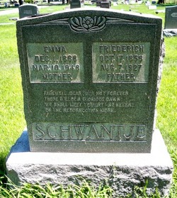
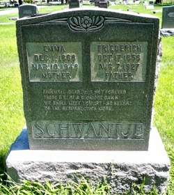
Emma Catharina Maria Saalfeld Schwantje
| Birth | : | 1 Dec 1868 Grossenkneten, Landkreis Oldenburg, Lower Saxony (Niedersachsen), Germany |
| Death | : | 10 Mar 1948 Columbus, Platte County, Nebraska, USA |
| Burial | : | Turtle Lake Cemetery, Turtle Lake, McLean County, USA |
| Coordinate | : | 47.5149994, -100.9077988 |
| Description | : | Daughter of Henry & Katrina (Krumland) Saalfeld. Married to Fred Schwantje. |
frequently asked questions (FAQ):
-
Where is Emma Catharina Maria Saalfeld Schwantje's memorial?
Emma Catharina Maria Saalfeld Schwantje's memorial is located at: Turtle Lake Cemetery, Turtle Lake, McLean County, USA.
-
When did Emma Catharina Maria Saalfeld Schwantje death?
Emma Catharina Maria Saalfeld Schwantje death on 10 Mar 1948 in Columbus, Platte County, Nebraska, USA
-
Where are the coordinates of the Emma Catharina Maria Saalfeld Schwantje's memorial?
Latitude: 47.5149994
Longitude: -100.9077988
Family Members:
Spouse
Children
Flowers:
Nearby Cemetories:
1. Turtle Lake Cemetery
Turtle Lake, McLean County, USA
Coordinate: 47.5149994, -100.9077988
2. Ingersoll Cemetery
Washburn, McLean County, USA
Coordinate: 47.4516000, -100.9915800
3. O'Shea Cemetery
Mercer, McLean County, USA
Coordinate: 47.5010000, -100.7802700
4. Saint Olaf Lutheran Cemetery
Turtle Lake, McLean County, USA
Coordinate: 47.6030900, -100.9094700
5. Peace Lutheran Cemetery
McLean County, USA
Coordinate: 47.5738983, -100.7996979
6. Darling Cemetery
McLean County, USA
Coordinate: 47.5597000, -101.0363998
7. Benedict Methodist Cemetery
Benedict, McLean County, USA
Coordinate: 47.4908981, -101.0521011
8. Bethal Baptist Cemetery
McLean County, USA
Coordinate: 47.4038700, -100.9071400
9. South Saint Olaf Cemetery
Turtle Lake, McLean County, USA
Coordinate: 47.4079933, -100.8432465
10. Medicine Hill Cemetery
McLean County, USA
Coordinate: 47.5966988, -100.7574997
11. Mercer Hillside Cemetery
Mercer, McLean County, USA
Coordinate: 47.4932300, -100.7062000
12. Our Savior Cemetery
McLean County, USA
Coordinate: 47.5894012, -100.7149963
13. Bethel Cemetery
Coleharbor, McLean County, USA
Coordinate: 47.6028350, -101.0999890
14. Kins Cemetery
Garrison, McLean County, USA
Coordinate: 47.6319912, -101.0799267
15. Underwood Cemetery
Underwood, McLean County, USA
Coordinate: 47.4664001, -101.1444016
16. Saint Bonaventure Catholic Church Cemetery
Underwood, McLean County, USA
Coordinate: 47.4535800, -101.1422450
17. Sverdrup Cemetery
McLean County, USA
Coordinate: 47.3563995, -101.0028000
18. Zion Lutheran Cemetery
Mercer, McLean County, USA
Coordinate: 47.3857000, -100.7367600
19. First German Cemetery
Garrison, McLean County, USA
Coordinate: 47.6325560, -101.1006490
20. Tabor Cemetery
McLean County, USA
Coordinate: 47.6546100, -100.7483600
21. Saint Johns Cemetery
Ruso, McLean County, USA
Coordinate: 47.6737099, -100.7859955
22. Zion Baptist Cemetery
McLean County, USA
Coordinate: 47.3518982, -100.7985992
23. East Crooked Lake Cemetery
Ruso, McLean County, USA
Coordinate: 47.6880417, -100.8184433
24. Saint Johns Cemetery
Underwood, McLean County, USA
Coordinate: 47.4364014, -101.1641998

