

Emma Elizabeth “Toots” Rourk Yancey
| Birth | : | 8 Sep 1926 Orangeburg County, South Carolina, USA |
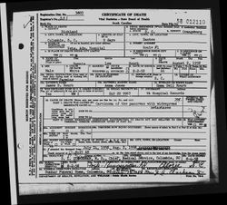
| Death | : | 23 Jan 2007 Saint Matthews, Calhoun County, South Carolina, USA |
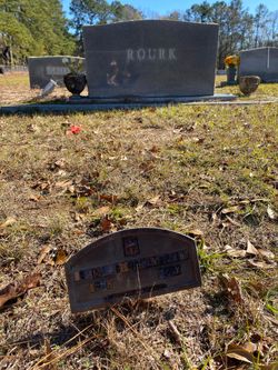
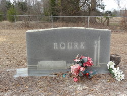
| Burial | : | Jerusalem Cemetery, Elloree, Orangeburg County, USA |
| Coordinate | : | 33.5102340, -80.5447570 |
| Description | : | Graveside services for Emma Elizabeth “Toots” Rourk Yancey, 80 of St. Matthews, will be held at 3 PM on Thursday, January 25, 2007, in Jerusalem United Methodist Church Cemetery, Old Number Six Highway, Elloree. She died Tuesday, January 23, at Calhoun Convalescent Center, St. Matthews, after an illness. She was born in Orangeburg County, a daughter of the late Bunnie Lee Rourk and the late Emma Delle Strock Pridgen. She was a member of Jerusalem United Methodist Church. She was a retired seamstress and painter. She was married to the late Solomon Yancey. Survivors include one son: Bunnie Solomon Yancey and wife,... Read More |
frequently asked questions (FAQ):
-
Where is Emma Elizabeth “Toots” Rourk Yancey's memorial?
Emma Elizabeth “Toots” Rourk Yancey's memorial is located at: Jerusalem Cemetery, Elloree, Orangeburg County, USA.
-
When did Emma Elizabeth “Toots” Rourk Yancey death?
Emma Elizabeth “Toots” Rourk Yancey death on 23 Jan 2007 in Saint Matthews, Calhoun County, South Carolina, USA
-
Where are the coordinates of the Emma Elizabeth “Toots” Rourk Yancey's memorial?
Latitude: 33.5102340
Longitude: -80.5447570
Family Members:
Parent

Spouse
Siblings
Children
Flowers:


Nearby Cemetories:
1. Jerusalem Cemetery
Elloree, Orangeburg County, USA
Coordinate: 33.5102340, -80.5447570
2. Mount Hebron Baptist Church Cemetery
Santee, Orangeburg County, USA
Coordinate: 33.5028570, -80.5381980
3. New Faith Community Church Cemetery
Elloree, Orangeburg County, USA
Coordinate: 33.5229150, -80.5477570
4. Hart Graveyard
Holly Hill, Orangeburg County, USA
Coordinate: 33.4918320, -80.5470820
5. Browning Branch Cemetery
Elloree, Orangeburg County, USA
Coordinate: 33.5231820, -80.5632140
6. Whitmore, Avinger, Norris, Felder Cemetery
Elloree, Orangeburg County, USA
Coordinate: 33.4870530, -80.5532600
7. Parlerville A.M.E. Church Cemetery
Santee, Orangeburg County, USA
Coordinate: 33.5208030, -80.5039540
8. Mount Pisgah Church Cemetery
Santee, Orangeburg County, USA
Coordinate: 33.5182200, -80.5027480
9. Saluda Baptist Church Cemetery
Elloree, Orangeburg County, USA
Coordinate: 33.4757900, -80.5597300
10. Fellowship of Praise
Santee, Orangeburg County, USA
Coordinate: 33.4934970, -80.5052100
11. Ark of God Cemetery
Santee, Orangeburg County, USA
Coordinate: 33.4630210, -80.5558220
12. Magrill Family Cemetery
Calhoun County, USA
Coordinate: 33.5601790, -80.5354270
13. Granger Baptist Church Cemetery
Elloree, Orangeburg County, USA
Coordinate: 33.4909840, -80.6030410
14. Gresham Cemetery
Orangeburg County, USA
Coordinate: 33.4906006, -80.6031036
15. Antioch Cemetery
Santee, Orangeburg County, USA
Coordinate: 33.4599991, -80.5258026
16. Smith-Dantzler Cemetery
Elloree, Orangeburg County, USA
Coordinate: 33.4941130, -80.6052520
17. Oak Grove Baptist Church Cemetery
Santee, Orangeburg County, USA
Coordinate: 33.4586400, -80.5296220
18. Trinity Lutheran Church Cemetery
Elloree, Orangeburg County, USA
Coordinate: 33.5603720, -80.5659850
19. McGrew Cemetery
Elloree, Orangeburg County, USA
Coordinate: 33.4859880, -80.6027150
20. Bookhart Cemetery
Elloree, Orangeburg County, USA
Coordinate: 33.5485992, -80.5924988
21. Chapel Hill Baptist Church Cemetery
Santee, Orangeburg County, USA
Coordinate: 33.4899690, -80.4829530
22. Hungerpiller Family Cemetery
Elloree, Orangeburg County, USA
Coordinate: 33.5049010, -80.6123380
23. Dantzler Family Cemetery
Elloree, Orangeburg County, USA
Coordinate: 33.4762456, -80.6037355
24. Immanuel Free Will Baptist Church and Cemetery
Santee, Orangeburg County, USA
Coordinate: 33.4621430, -80.5007070