
Emma Kennebeck Kraus
| Birth | : | 28 Mar 1900 Roselle, Carroll County, Iowa, USA |
| Death | : | 16 Dec 1997 Carroll, Carroll County, Iowa, USA |
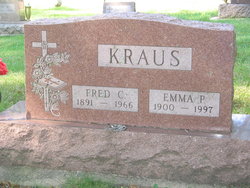
| Burial | : | Mount Olivet Cemetery, Carroll, Carroll County, USA |
| Coordinate | : | 42.0536340, -94.8595510 |
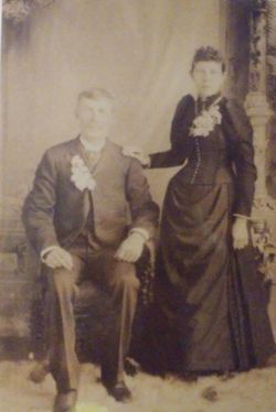
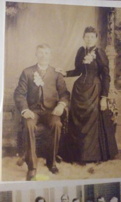
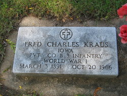
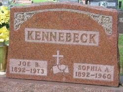
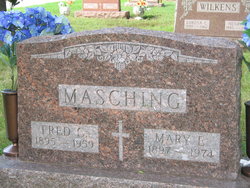
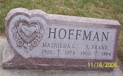
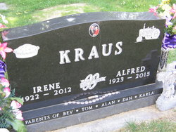
| Description | : | Emma was a daughter of Bernard and Julia (Meischeid) Kennebeck. She was raised in Roselle and attended Holy Angels School. She married Fred Kraus January 27, 1920 at Holy Angels Church in Roselle. The couple farmed in the Roselle, Willey and Lidderdale communities until they retired in 1957 and moved to Carroll. They were parents of six children: Paul, Alfred, Merlin, Robert, Dorothy and Louise. She was preceded in death by her parents, her husband, Fred, in Oct. 1966; a son-in-law, James Owens; a grandson, Cyril Owens; three great-grandchildren; four brothers: William, Joseph, Edward and Albert Kennebeck; and three sisters: Mayme Masching, Tillie Hoffman... Read More |
frequently asked questions (FAQ):
-
Where is Emma Kennebeck Kraus's memorial?
Emma Kennebeck Kraus's memorial is located at: Mount Olivet Cemetery, Carroll, Carroll County, USA.
-
When did Emma Kennebeck Kraus death?
Emma Kennebeck Kraus death on 16 Dec 1997 in Carroll, Carroll County, Iowa, USA
-
Where are the coordinates of the Emma Kennebeck Kraus's memorial?
Latitude: 42.0536340
Longitude: -94.8595510
Family Members:
Parent
Spouse
Siblings

Children
Flowers:


Nearby Cemetories:
1. Mount Olivet Cemetery
Carroll, Carroll County, USA
Coordinate: 42.0536340, -94.8595510
2. Carroll City Cemetery
Carroll, Carroll County, USA
Coordinate: 42.0560963, -94.8599856
3. Holy Angels Cemetery
Carroll County, USA
Coordinate: 42.0014000, -94.9141998
4. Saint Francis Cemetery
Maple River, Carroll County, USA
Coordinate: 42.0969009, -94.9372025
5. Saint Marys Catholic Cemetery
Willey, Carroll County, USA
Coordinate: 41.9783363, -94.8212204
6. Holy Family Cemetery
Lidderdale, Carroll County, USA
Coordinate: 42.1178017, -94.7839966
7. West Lawn Cemetery
Glidden, Carroll County, USA
Coordinate: 42.0649986, -94.7406006
8. Immanuel Cemetery
Lidderdale, Carroll County, USA
Coordinate: 42.1389008, -94.8022003
9. Saint Augustine Cemetery
Halbur, Carroll County, USA
Coordinate: 42.0066986, -94.9744034
10. Our Lady Of Mount Carmel Cemetery
Mount Carmel, Carroll County, USA
Coordinate: 42.1547012, -94.9088974
11. Arcadia Cemetery
Arcadia Township, Carroll County, USA
Coordinate: 42.1000680, -95.0130550
12. East Liberty Cemetery
Lidderdale, Carroll County, USA
Coordinate: 42.1591988, -94.7636032
13. McCurdy Cemetery
Carroll County, USA
Coordinate: 41.9403000, -94.7649994
14. Saint Johns Catholic Cemetery
Arcadia, Carroll County, USA
Coordinate: 42.0855406, -95.0341577
15. Dickson Cemetery
Glidden Township, Carroll County, USA
Coordinate: 42.1074982, -94.6939011
16. Saint Bernards Cemetery
Breda, Carroll County, USA
Coordinate: 42.1786003, -94.9732971
17. Elba Cemetery
Templeton, Carroll County, USA
Coordinate: 41.9068985, -94.9131012
18. Sacred Heart Cemetery
Templeton, Carroll County, USA
Coordinate: 41.9138746, -94.9460994
19. Dedham Cemetery
Dedham, Carroll County, USA
Coordinate: 41.8993988, -94.8225021
20. Saint Josephs Cemetery
Dedham, Carroll County, USA
Coordinate: 41.8993988, -94.8210983
21. North Coon Cemetery
Carroll County, USA
Coordinate: 42.1260986, -94.6716995
22. Old Carrollton Cemetery
Carrollton, Carroll County, USA
Coordinate: 41.9233017, -94.7403030
23. Lanesboro Cemetery
Lanesboro, Carroll County, USA
Coordinate: 42.1810989, -94.7230988
24. Luckow Cemetery
Auburn, Sac County, USA
Coordinate: 42.2168999, -94.9266968