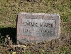
Emma Mark
| Birth | : | 25 Dec 1872 Mercer County, Missouri, USA |
| Death | : | 28 Jul 1950 Mercer County, Missouri, USA |
| Burial | : | Hedens Kyrkogård, Piteå, Piteå kommun, Sweden |
| Coordinate | : | 65.3718390, 21.3629990 |
| Plot | : | 3 4-7 |
| Description | : | A book is available written by Emma Mark and published by Roy Mark. If you are interested in this family you may learn more about it and it's availability at the following link. http://www.roy-mark.com/markhistory.htm |
frequently asked questions (FAQ):
-
Where is Emma Mark's memorial?
Emma Mark's memorial is located at: Hedens Kyrkogård, Piteå, Piteå kommun, Sweden.
-
When did Emma Mark death?
Emma Mark death on 28 Jul 1950 in Mercer County, Missouri, USA
-
Where are the coordinates of the Emma Mark's memorial?
Latitude: 65.3718390
Longitude: 21.3629990
Family Members:
Parent
Siblings
Flowers:
Nearby Cemetories:
1. Hedens Kyrkogård
Piteå, Piteå kommun, Sweden
Coordinate: 65.3718390, 21.3629990
2. Muslimska Kyrkogården
Ojebyn, Piteå kommun, Sweden
Coordinate: 65.3690850, 21.3619690
3. Öjeby Kyrkogård
Ojebyn, Piteå kommun, Sweden
Coordinate: 65.3455660, 21.3933039
4. Norrfjärden Kyrkogården
Norrfjarden, Piteå kommun, Sweden
Coordinate: 65.4215400, 21.4895700
5. Hortlax Kyrkogård
Hortlax, Piteå kommun, Sweden
Coordinate: 65.2852000, 21.3988000
6. Hortlax Skogskyrkogård
Hortlax, Piteå kommun, Sweden
Coordinate: 65.2840170, 21.4021820
7. Nederluleå kyrkogård
Gammelstad, Luleå kommun, Sweden
Coordinate: 65.6445700, 22.0288400
8. Innerstadens griftegård
Luleå, Luleå kommun, Sweden
Coordinate: 65.5914314, 22.1575676
9. Långträsk Kyrkogård
Piteå kommun, Sweden
Coordinate: 65.3866563, 20.3234943
10. Skogskyrkogården Södra Svartbyn
Bodens kommun, Sweden
Coordinate: 65.7964697, 21.7598486
11. Lundagård Kyrkogård
Boden, Bodens kommun, Sweden
Coordinate: 65.8193519, 21.6787128
12. Överluleå Gamla Kyrkogården
Boden, Bodens kommun, Sweden
Coordinate: 65.8296808, 21.6871287
13. Råneå kyrkogård
Råneå, Luleå kommun, Sweden
Coordinate: 65.8671127, 22.2993637
14. Alhems Kyrkogård (skogskyrkogården)
Skellefteå, Skellefteå kommun, Sweden
Coordinate: 64.7557797, 20.9985884
15. Skellefteå Västra kyrkogård
Skellefteå, Skellefteå kommun, Sweden
Coordinate: 64.7519900, 20.9186000
16. Lund Cemetery
Lund, Skellefteå kommun, Sweden
Coordinate: 64.7491080, 20.9055672
17. Gråträsk Kyrkogård
Gratrask, Piteå kommun, Sweden
Coordinate: 65.4861640, 19.7961550
18. Vara Cemetery
Vara, Vara kommun, Sweden
Coordinate: 64.7456327, 20.8466761
19. Sävenäs
Savenas, Skellefteå kommun, Sweden
Coordinate: 64.6924063, 21.2107215
20. Glommersträsk Kyrkogård
Glommerstrask, Arvidsjaurs kommun, Sweden
Coordinate: 65.2812400, 19.6099900
21. Bureå Kyrkogård
Burea, Skellefteå kommun, Sweden
Coordinate: 64.6195220, 21.2026780
22. Älvkyrkogården
Kalix kommun, Sweden
Coordinate: 65.8596210, 23.1327860
23. Morjärvs Kyrkogård
Kalix kommun, Sweden
Coordinate: 66.0693020, 22.7007360
24. Norsjö kyrkogård
Norsjö, Norsjö kommun, Sweden
Coordinate: 64.9147237, 19.4762989


