
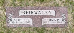
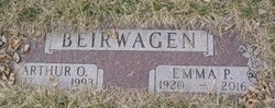
Emma Paulina Radke Beirwagen
| Birth | : | 19 Mar 1920 Mercer County, North Dakota, USA |
| Death | : | 1 Mar 2016 Fort Benton, Chouteau County, Montana, USA |
| Burial | : | Big Sandy Cemetery, Big Sandy, Chouteau County, USA |
| Coordinate | : | 48.1801170, -110.1207500 |
frequently asked questions (FAQ):
-
Where is Emma Paulina Radke Beirwagen's memorial?
Emma Paulina Radke Beirwagen's memorial is located at: Big Sandy Cemetery, Big Sandy, Chouteau County, USA.
-
When did Emma Paulina Radke Beirwagen death?
Emma Paulina Radke Beirwagen death on 1 Mar 2016 in Fort Benton, Chouteau County, Montana, USA
-
Where are the coordinates of the Emma Paulina Radke Beirwagen's memorial?
Latitude: 48.1801170
Longitude: -110.1207500
Family Members:
Parent
Spouse

Siblings


Flowers:


Nearby Cemetories:
1. Big Sandy Cemetery
Big Sandy, Chouteau County, USA
Coordinate: 48.1801170, -110.1207500
2. Box Elder Cemetery
Box Elder, Hill County, USA
Coordinate: 48.3274000, -110.0095000
3. Kenilworth Cemetery
Chouteau County, USA
Coordinate: 48.2192001, -110.4188995
4. Rocky Boy Cemetery
Rocky Boy, Hill County, USA
Coordinate: 48.2572410, -109.7923690
5. Rocky Boy Gravel Cemetery
Rocky Boy, Hill County, USA
Coordinate: 48.2427720, -109.7596500
6. Cottonwood Lutheran Church Cemetery
Havre, Hill County, USA
Coordinate: 48.4545000, -110.1748000
7. Gildford Hill County Cemetery
Gildford, Hill County, USA
Coordinate: 48.5778008, -110.2957993
8. Clear Lake Cemetery
Chouteau County, USA
Coordinate: 47.7731018, -110.2514038
9. Hingham Union Cemetery
Hingham, Hill County, USA
Coordinate: 48.5601570, -110.4178980
10. Sunset Garden Park
Havre, Hill County, USA
Coordinate: 48.5531006, -109.8019028
11. Graceville Cemetery
Chouteau County, USA
Coordinate: 47.7505989, -110.0875015
12. Hungry Hollow Cemetery
Blaine County, USA
Coordinate: 48.2103004, -109.4677963
13. Highland Cemetery
Havre, Hill County, USA
Coordinate: 48.5463982, -109.6900024
14. Mount Hope Cemetery
Havre, Hill County, USA
Coordinate: 48.5540000, -109.7050000
15. Calvary Cemetery
Havre, Hill County, USA
Coordinate: 48.5457000, -109.6883000
16. Rudyard Cemetery
Rudyard, Hill County, USA
Coordinate: 48.5659500, -110.5390000
17. Riverside Cemetery
Fort Benton, Chouteau County, USA
Coordinate: 47.8402330, -110.6408830
18. Old Shep Gravesite
Fort Benton, Chouteau County, USA
Coordinate: 47.8369000, -110.6557000
19. Milk River Valley Church Graveyard
Hill County, USA
Coordinate: 48.6787180, -110.2261080
20. Museum of the Upper Missouri
Fort Benton, Chouteau County, USA
Coordinate: 47.8207000, -110.6642000
21. Inverness Cemetery
Hill County, USA
Coordinate: 48.5531340, -110.6688450
22. Grainbelt Cemetery
Hill County, USA
Coordinate: 48.6828003, -109.8657990
23. Montague Cemetery
Chouteau County, USA
Coordinate: 47.6783000, -110.4670000
24. North Havre Lutheran Church Graveyard (Defunct)
Havre, Hill County, USA
Coordinate: 48.6538903, -109.6815870