
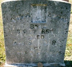

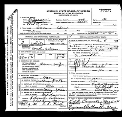
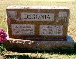
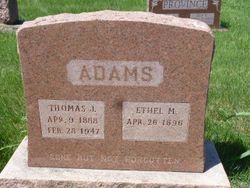
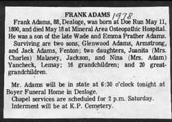
Emma Prather Adams
| Birth | : | 17 Sep 1857 |
| Death | : | 9 Mar 1928 |
| Burial | : | Saint Bernard Cemetery, Lindsay, Platte County, USA |
| Coordinate | : | 41.7155991, -97.6286011 |
| Description | : | Emma was the daughter of William Bay Ray Prater and Mary Jane Farrow. In 1886 she married Wade Adams. Emma and Wade were the parents of Annie, Thomas, Frank, Ida, Edward, and Spencer Adams. |
frequently asked questions (FAQ):
-
Where is Emma Prather Adams's memorial?
Emma Prather Adams's memorial is located at: Saint Bernard Cemetery, Lindsay, Platte County, USA.
-
When did Emma Prather Adams death?
Emma Prather Adams death on 9 Mar 1928 in
-
Where are the coordinates of the Emma Prather Adams's memorial?
Latitude: 41.7155991
Longitude: -97.6286011
Family Members:
Parent

Spouse
Siblings

Children
Flowers:


Nearby Cemetories:
1. Saint Bernard Cemetery
Lindsay, Platte County, USA
Coordinate: 41.7155991, -97.6286011
2. Saint Pauls Lutheran Cemetery
Platte County, USA
Coordinate: 41.7425003, -97.6286011
3. Holy Family Cemetery
Lindsay, Platte County, USA
Coordinate: 41.6921997, -97.6832962
4. Sacred Heart Cemetery
Cornlea, Platte County, USA
Coordinate: 41.6808014, -97.5708008
5. Evangelical Cemetery
Madison County, USA
Coordinate: 41.7625008, -97.6772003
6. Kalamazoo Cemetery
Madison County, USA
Coordinate: 41.7787000, -97.6195000
7. Granville Cemetery
Cornlea, Platte County, USA
Coordinate: 41.6712450, -97.5542160
8. Saint Johns Catholic Cemetery
Lindsay, Platte County, USA
Coordinate: 41.6293500, -97.6282500
9. Zion Evangelical Cemetery
Madison, Madison County, USA
Coordinate: 41.8010000, -97.5793000
10. Green Garden Cemetery
Madison County, USA
Coordinate: 41.8100014, -97.5796967
11. Moriah Cemetery
Platte County, USA
Coordinate: 41.6268997, -97.5622025
12. Humphrey Cemetery
Humphrey, Platte County, USA
Coordinate: 41.6963997, -97.4931030
13. Saint Francis Cemetery
Humphrey, Platte County, USA
Coordinate: 41.6921997, -97.4935989
14. Hope Cemetery
Platte County, USA
Coordinate: 41.7383003, -97.7742004
15. Bethany Lutheran Cemetery
Platte County, USA
Coordinate: 41.6232700, -97.7177200
16. Looking Glass Cemetery
Rosenborg, Platte County, USA
Coordinate: 41.6571000, -97.7617000
17. Iowa Valley Cemetery
Madison County, USA
Coordinate: 41.8292007, -97.6588974
18. Shell Creek Lutheran Cemetery
Newman Grove, Madison County, USA
Coordinate: 41.7717018, -97.7652969
19. Burrows Cemetery
Platte County, USA
Coordinate: 41.5983009, -97.5813980
20. Postville Cemetery
Platte County, USA
Coordinate: 41.5924644, -97.6203079
21. Saint Ansgar Cemetery
Rosenborg, Platte County, USA
Coordinate: 41.6334000, -97.7539000
22. Palestine Cemetery
Rosenborg, Platte County, USA
Coordinate: 41.5980000, -97.7057000
23. Tracy Valley Cemetery
Humphrey, Platte County, USA
Coordinate: 41.7214012, -97.4480972
24. Saint Michaels Cemetery
Tarnov, Platte County, USA
Coordinate: 41.6178017, -97.5042038