
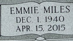
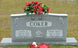
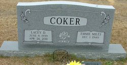

Emmie Miles Coker
| Birth | : | 1 Dec 1940 Florence County, South Carolina, USA |
| Death | : | 15 Apr 2015 |
| Burial | : | Pinedale Pentecostal Holiness Church, Turbeville, Clarendon County, USA |
| Coordinate | : | 33.8885810, -79.9608860 |
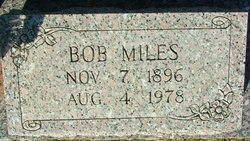
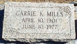
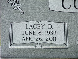
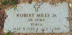
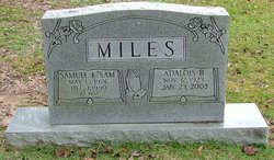
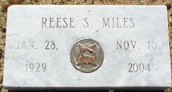
| Description | : | Emmie Coker age 74, died April 15, 2015 at her home after an illness. Born in Florence County, she was a daughter of the late Bob Miles and Carrie Ella Kirby Miles. She was a member of Maranatha Pentecostal Holiness Church, The Women’s Ministry of the church, served as Commander of The Royal Rangers, and Commander of Straight Arrow Buckaroo’s youth ministry for boys. She was preceded in death by her husband, Lacey Coker, a sister, Carrie Godwin, three brothers, Robert Miles, Samuel Miles and Rev. Reese Miles. |
frequently asked questions (FAQ):
-
Where is Emmie Miles Coker's memorial?
Emmie Miles Coker's memorial is located at: Pinedale Pentecostal Holiness Church, Turbeville, Clarendon County, USA.
-
When did Emmie Miles Coker death?
Emmie Miles Coker death on 15 Apr 2015 in
-
Where are the coordinates of the Emmie Miles Coker's memorial?
Latitude: 33.8885810
Longitude: -79.9608860
Family Members:
Parent
Spouse
Siblings

Flowers:


Nearby Cemetories:
1. Pinedale Pentecostal Holiness Church
Turbeville, Clarendon County, USA
Coordinate: 33.8885810, -79.9608860
2. New McFadden Cemetery
Olanta, Florence County, USA
Coordinate: 33.8949090, -79.9445920
3. Rush Cemetery
Florence County, USA
Coordinate: 33.8998410, -79.9411660
4. Union Hill Baptist Church Cemetery
Turbeville, Clarendon County, USA
Coordinate: 33.9035810, -79.9789650
5. New Covenant Pentecostal Holiness Church Cemetery
Turbeville, Clarendon County, USA
Coordinate: 33.9099510, -79.9706020
6. Thomas Cemetery
Olanta, Florence County, USA
Coordinate: 33.9142350, -79.9387630
7. McFadden Cemetery
New Zion, Clarendon County, USA
Coordinate: 33.8605670, -79.9430100
8. Horse Branch Free Will Baptist Cemetery
Turbeville, Clarendon County, USA
Coordinate: 33.8907260, -79.9996940
9. Saint James Baptist Church Cemetery
Clarendon County, USA
Coordinate: 33.8577995, -79.9477997
10. New Town Cemetery
Clarendon County, USA
Coordinate: 33.8843994, -79.9175034
11. Olanta Baptist Church Cemetery
Olanta, Florence County, USA
Coordinate: 33.9232000, -79.9380290
12. Turbeville Southern Methodist Church Cemetery
Turbeville, Clarendon County, USA
Coordinate: 33.8944450, -80.0142490
13. Pine Grove United Methodist Church Cemetery
Turbeville, Clarendon County, USA
Coordinate: 33.8947890, -80.0141950
14. Olanta Pentecostal Holiness Church Cemetery
Olanta, Florence County, USA
Coordinate: 33.9253260, -79.9294360
15. Turbeville First Baptist Church Cemetery
Turbeville, Clarendon County, USA
Coordinate: 33.8933570, -80.0149730
16. Hickory Grove Baptist Church
Clarendon County, USA
Coordinate: 33.8797640, -80.0169150
17. Barrineau Pentecostal Holiness Church Cemetery
Barrineau Crossroads, Clarendon County, USA
Coordinate: 33.8720500, -79.9060380
18. Olanta Church of God of Prophecy Cemetery
Olanta, Florence County, USA
Coordinate: 33.9309250, -79.9275540
19. Pygot Family Cemetery
Olanta, Florence County, USA
Coordinate: 33.9341361, -79.9324101
20. W.L. Coker Family Cemetery
Turbeville, Clarendon County, USA
Coordinate: 33.8945530, -80.0246780
21. First Presbyterian Church Cemetery
Olanta, Florence County, USA
Coordinate: 33.9375000, -79.9349976
22. Coker-Miles Cemetery
Florence County, USA
Coordinate: 33.9435530, -79.9664350
23. Floyd Cemetery
Florence County, USA
Coordinate: 33.9367590, -79.9200760
24. Gibbons Family Cemetery
Turbeville, Clarendon County, USA
Coordinate: 33.8571243, -80.0251007