


Emogene “Emma” Williams Mitchell
| Birth | : | 12 Nov 1852 Grafton, Grafton County, New Hampshire, USA |
| Death | : | 19 Sep 1924 Ashland, Grafton County, New Hampshire, USA |
| Burial | : | Wivenhoe General Cemetery, Burnie, Burnie City, Australia |
| Coordinate | : | -41.0722433, 145.9305850 |
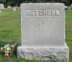
| Inscription | : | Family Stone: Mitchell | Emma His Wife | 1852 – 1921 Footstone: Mother |
| Description | : | The funeral of Mrs. Emma W., wife of Brooks Mitchell was held at the Methodist Church on Washington Street Monday afternoon. The officiating clergyman was Rev. Earle Fellows. Interment was in Green Grove Cemetery. E.G. Gammons was the undertaker in charge. The bearers were Henry Morse, Frank Eastman, Roy Wilkins and Harold Knowlton. Many floral tributes testified to the high esteem in which Mrs. Mitchell was held by her many friends and the public in general. Mrs. Mitchell was born in Grafton November 12, 1852. She passed away at her home last week Friday. ... Read More |
frequently asked questions (FAQ):
-
Where is Emogene “Emma” Williams Mitchell's memorial?
Emogene “Emma” Williams Mitchell's memorial is located at: Wivenhoe General Cemetery, Burnie, Burnie City, Australia.
-
When did Emogene “Emma” Williams Mitchell death?
Emogene “Emma” Williams Mitchell death on 19 Sep 1924 in Ashland, Grafton County, New Hampshire, USA
-
Where are the coordinates of the Emogene “Emma” Williams Mitchell's memorial?
Latitude: -41.0722433
Longitude: 145.9305850
Family Members:
Spouse

Children

Flowers:


Nearby Cemetories:
1. Wivenhoe General Cemetery
Burnie, Burnie City, Australia
Coordinate: -41.0722433, 145.9305850
2. Burnie Anglican Church Cemetery
Burnie, Burnie City, Australia
Coordinate: -41.0523570, 145.9045550
3. Burnie Lawn Cemetery
East Cam, Burnie City, Australia
Coordinate: -41.0583700, 145.8518460
4. Somerset Cemetery
Somerset, Waratah-Wynyard Council, Australia
Coordinate: -41.0434790, 145.8292770
5. Penguin General Cemetery
Penguin, Central Coast Council, Australia
Coordinate: -41.1118724, 146.0646653
6. Ridgley General Cemetery
Ridgley, Burnie City, Australia
Coordinate: -41.1506070, 145.8236570
7. Lower Mount Hicks Cemetery
Lower Mount Hicks, Waratah-Wynyard Council, Australia
Coordinate: -41.0422810, 145.7384950
8. Central Coast Memorial Park
Ulverstone, Central Coast Council, Australia
Coordinate: -41.1397940, 146.1081230
9. South Riana Uniting Church Cemetery
Central Coast Council, Australia
Coordinate: -41.2351280, 145.9792410
10. Jenner Street Old General Cemetery
Wynyard, Waratah-Wynyard Council, Australia
Coordinate: -40.9851700, 145.7277810
11. Wynyard General Cemetery
Wynyard, Waratah-Wynyard Council, Australia
Coordinate: -40.9820596, 145.7179781
12. St. John's Anglican Churchyard
North Motton, Central Coast Council, Australia
Coordinate: -41.2076090, 146.1088350
13. North Motton Methodist Cemetery
North Motton, Central Coast Council, Australia
Coordinate: -41.2091270, 146.1096290
14. Ulverstone General Cemetery
Ulverstone, Central Coast Council, Australia
Coordinate: -41.1625310, 146.1637200
15. Table Cape Cemetery
Table Cape, Waratah-Wynyard Council, Australia
Coordinate: -40.9463750, 145.7279330
16. Ulverstone Anglican Church Cemetery
Ulverstone, Central Coast Council, Australia
Coordinate: -41.1584540, 146.1683450
17. Henrietta Cemetery
Henrietta, Waratah-Wynyard Council, Australia
Coordinate: -41.1543686, 145.6882431
18. George Woodhouse Lookout
Riana, Central Coast Council, Australia
Coordinate: -41.2818184, 145.9948120
19. North West Crematorium and Memorial Garden
Ulverstone, Central Coast Council, Australia
Coordinate: -41.1592500, 146.1943370
20. Flowerdale Cemetery
Flowerdale, Waratah-Wynyard Council, Australia
Coordinate: -40.9679460, 145.6740580
21. McCulloch Family Cemetery
Ulverstone, Central Coast Council, Australia
Coordinate: -41.2289670, 146.1591010
22. Sprent Uniting Church Cemetery
Sprent, Central Coast Council, Australia
Coordinate: -41.2491180, 146.1722070
23. St. Andrew's Churchyard
Sprent, Central Coast Council, Australia
Coordinate: -41.2596490, 146.1593130
24. Forth Methodist Cemetery
Forth, Devonport City, Australia
Coordinate: -41.1797840, 146.2435630