

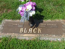
Erma Mae Mitchell Black
| Birth | : | 29 Sep 1912 |
| Death | : | 28 Nov 2001 Huntington, Cabell County, West Virginia, USA |
| Burial | : | Saint John's Anglican Church Cemetery, Port Hope, Northumberland County, Canada |
| Coordinate | : | 43.9558800, -78.3169100 |
| Plot | : | Section S |
| Description | : | (Nov 29, 2001) ERMA MAE MITCHELL BLACK, 89, of Huntington, widow of Lloyd H. Black, died Wednesday in St. Mary?s Hospital. She was a retired elevator operator for First Huntington National Bank. Survivors include one son, Lloyd Junior Black of Huntington; three sisters, Leila Myers, Faye Hicks and Alfreda Mitchell, all of Huntington; and one brother, Earsley Mitchell of Proctorville, Ohio. Funeral 1 p.m. Friday at Beard Mortuary, Huntington; burial in Woodmere Memorial Park. Friends may call from 6 to 8 p.m. today at the funeral home. |
frequently asked questions (FAQ):
-
Where is Erma Mae Mitchell Black's memorial?
Erma Mae Mitchell Black's memorial is located at: Saint John's Anglican Church Cemetery, Port Hope, Northumberland County, Canada.
-
When did Erma Mae Mitchell Black death?
Erma Mae Mitchell Black death on 28 Nov 2001 in Huntington, Cabell County, West Virginia, USA
-
Where are the coordinates of the Erma Mae Mitchell Black's memorial?
Latitude: 43.9558800
Longitude: -78.3169100
Family Members:
Parent
Spouse
Siblings
Children

Flowers:


Nearby Cemetories:
1. Saint John's Anglican Church Cemetery
Port Hope, Northumberland County, Canada
Coordinate: 43.9558800, -78.3169100
2. Port Hope Union Cemetery
Port Hope, Northumberland County, Canada
Coordinate: 43.9564000, -78.3178700
3. Saint Mary's Cemetery
Port Hope, Northumberland County, Canada
Coordinate: 43.9579500, -78.3201900
4. Port Hope Pioneer Presbyterian Cemetery
Port Hope, Northumberland County, Canada
Coordinate: 43.9534350, -78.3030130
5. Welcome United Church Cemetery
Welcome, Northumberland County, Canada
Coordinate: 43.9630100, -78.3279900
6. Saint Mark's Anglican Church Cemetery
Port Hope, Northumberland County, Canada
Coordinate: 43.9515220, -78.2898270
7. Walker Cemetery
Welcome, Northumberland County, Canada
Coordinate: 43.9698540, -78.3611440
8. Canton Cemetery
Canton, Northumberland County, Canada
Coordinate: 43.9963400, -78.3465700
9. Wesleyville Cemetery
Wesleyville, Northumberland County, Canada
Coordinate: 43.9259810, -78.4156070
10. Bethel Grove Cemetery
Hamilton Township, Northumberland County, Canada
Coordinate: 44.0295120, -78.2786530
11. Knoxville Presbyterian Church Cemetery
Port Hope, Northumberland County, Canada
Coordinate: 44.0341060, -78.3378510
12. Zion Cemetery
Port Hope, Northumberland County, Canada
Coordinate: 43.9694646, -78.4395690
13. Saint Michael's Cemetery
Cobourg, Northumberland County, Canada
Coordinate: 43.9677900, -78.1908900
14. Precious Corners Cemetery
Precious Corners, Northumberland County, Canada
Coordinate: 44.0083370, -78.2094060
15. Saint Andrew's Presbyterian Cemetery
Cobourg, Northumberland County, Canada
Coordinate: 43.9711058, -78.1854916
16. Saint Pauls Anglican Church Cemetery
Perrytown, Northumberland County, Canada
Coordinate: 44.0423520, -78.3785500
17. Perrytown Presbyterian Cemetery
Perrytown, Northumberland County, Canada
Coordinate: 44.0408200, -78.3849000
18. St. Peter's Anglican Church Cemetery
Cobourg, Northumberland County, Canada
Coordinate: 43.9747660, -78.1824020
19. Lent's Cemetery
Precious Corners, Northumberland County, Canada
Coordinate: 44.0108100, -78.1992100
20. Providence Cemetery
Port Hope, Northumberland County, Canada
Coordinate: 44.0568300, -78.3161300
21. Cobourg Union Cemetery
Cobourg, Northumberland County, Canada
Coordinate: 43.9765000, -78.1775600
22. Camborne United Church Cemetery
Camborne, Northumberland County, Canada
Coordinate: 44.0343488, -78.2186437
23. St. Paul's United Church Cemetery
Cold Springs, Northumberland County, Canada
Coordinate: 44.0593685, -78.2113455
24. Lakeview Cemetery
Newtonville, Durham Regional Municipality, Canada
Coordinate: 43.9373400, -78.4983700