
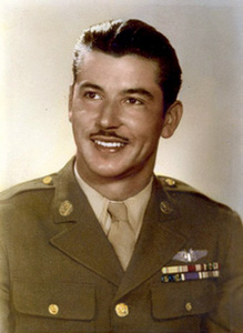
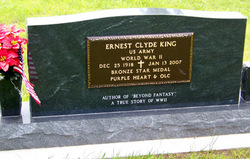

Ernest Clyde “Ernie” King
| Birth | : | 25 Dec 1918 Chanute, Neosho County, Kansas, USA |
| Death | : | 13 Jan 2007 Chanute, Neosho County, Kansas, USA |
| Burial | : | Lafayette Cemetery, Lafayette, Boulder County, USA |
| Coordinate | : | 40.0009000, -105.0925000 |
| Plot | : | Sec 200 Blk 5 Lot 127 Sp 4 |
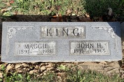
| Description | : | ********************** Chanute Tribune ~ Chanute, KS ~ January 16, 2007 Ernest "Ernie" Clyde King, 88, Chanute, KS, died Saturday, Jan. 13, 2007 at Neosho Memorial Regional Medical Center, Chanute, Kansas. He was born Dec. 25, 1918 to John H. and Maggie (Myers) King in Chanute, Kansas. He graduated from Chanute High School in 1936. During World War II he served in the US Army Air Force as a gunner on a B-17 Bomber flying out of England. Among the battle awards he received would include four Air Medals, two Purple Hearts, two European-African-Middle Eastern Medals, the American Defense, American Theater, Good Conduct, Victory,... Read More |
frequently asked questions (FAQ):
-
Where is Ernest Clyde “Ernie” King's memorial?
Ernest Clyde “Ernie” King's memorial is located at: Lafayette Cemetery, Lafayette, Boulder County, USA.
-
When did Ernest Clyde “Ernie” King death?
Ernest Clyde “Ernie” King death on 13 Jan 2007 in Chanute, Neosho County, Kansas, USA
-
Where are the coordinates of the Ernest Clyde “Ernie” King's memorial?
Latitude: 40.0009000
Longitude: -105.0925000
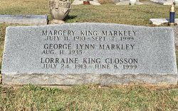
Family Members:
Parent

Spouse
Siblings


Flowers:


Nearby Cemetories:
1. Lafayette Cemetery
Lafayette, Boulder County, USA
Coordinate: 40.0009000, -105.0925000
2. Louisville Cemetery
Louisville, Boulder County, USA
Coordinate: 39.9730988, -105.1091995
3. Coal Creek Cemetery
Louisville, Boulder County, USA
Coordinate: 39.9728000, -105.1140000
4. Mount Pleasant Cemetery
Erie, Weld County, USA
Coordinate: 40.0512085, -105.0373993
5. Superior Cemetery
Superior, Boulder County, USA
Coordinate: 39.9514008, -105.1557999
6. Lutheran Church of Hope Columbarium
Broomfield, Broomfield County, USA
Coordinate: 39.9291000, -105.0853000
7. Holy Comforter Episcopal Church Columbarium
Broomfield, Broomfield County, USA
Coordinate: 39.9283480, -105.0888490
8. Monarch Number 2 Coal Mine Monument
Broomfield, Broomfield County, USA
Coordinate: 39.9365270, -105.1378080
9. Lakeview Cemetery
Broomfield, Broomfield County, USA
Coordinate: 39.9286003, -105.0725021
10. Broomfield County Commons Cemetery
Broomfield, Broomfield County, USA
Coordinate: 39.9289322, -105.0525589
11. Sacred Heart of Mary Cemetery
Boulder, Boulder County, USA
Coordinate: 39.9891663, -105.1958313
12. Evergreen Memorial Gardens
Broomfield, Broomfield County, USA
Coordinate: 39.9975014, -104.9835968
13. Valmont Cemetery
Valmont, Boulder County, USA
Coordinate: 40.0293999, -105.2071991
14. Poor Farm Cemetery
Boulder, Boulder County, USA
Coordinate: 40.0454950, -105.2054940
15. Wesley Chapel Cemetery
Westminster, Adams County, USA
Coordinate: 39.9155998, -104.9957962
16. Saint Andrews Presbyterian Church Columbarium
Boulder, Boulder County, USA
Coordinate: 39.9993000, -105.2465000
17. Pleasantview Ridge Cemetery
Weld County, USA
Coordinate: 40.1166115, -105.0551834
18. Mountain View Memorial Park
Boulder, Boulder County, USA
Coordinate: 40.0391300, -105.2503100
19. Saint Aidans Episcopal Church Columbarium
Boulder, Boulder County, USA
Coordinate: 40.0085000, -105.2628000
20. Niwot Cemetery
Niwot, Boulder County, USA
Coordinate: 40.1130981, -105.1847000
21. Green Mountain Cemetery
Boulder, Boulder County, USA
Coordinate: 39.9947014, -105.2671967
22. Grace Lutheran Church Columbarium
Boulder, Boulder County, USA
Coordinate: 40.0056000, -105.2766000
23. Burlington Cemetery
Longmont, Boulder County, USA
Coordinate: 40.1417007, -105.1200027
24. Pratt Cemetery
Longmont, Boulder County, USA
Coordinate: 40.1419000, -105.1221000