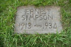
Ernest Lloyd Simpson
| Birth | : | 1913 Drumheller, Strathmore Census Division, Alberta, Canada |
| Death | : | 13 Jun 1934 Fairview, Grande Prairie Census Division, Alberta, Canada |
| Burial | : | Waterhole Cemetery, Waterhole, Grande Prairie Census Division, Canada |
| Coordinate | : | 56.0150500, -118.3931200 |
| Description | : | Runaway Is Fatal To Fairview Man Ernest Simpson, 19 of Black Duck District near Fairview was killed Wednesday in a runaway accident. Young Simpson was driving a team of bronchos into Fairview hitched to a wagon load of wood when a bicycle came along the road from the opposite direction and scared the horses. They bolted and Simpson was thrown off the wagon in the path of the wheels, one of which passed right over his head. He was rushed to the hospital here but died within 15 minutes of the accident. Coroner Dr. O. J. McFayden... Read More |
frequently asked questions (FAQ):
-
Where is Ernest Lloyd Simpson's memorial?
Ernest Lloyd Simpson's memorial is located at: Waterhole Cemetery, Waterhole, Grande Prairie Census Division, Canada.
-
When did Ernest Lloyd Simpson death?
Ernest Lloyd Simpson death on 13 Jun 1934 in Fairview, Grande Prairie Census Division, Alberta, Canada
-
Where are the coordinates of the Ernest Lloyd Simpson's memorial?
Latitude: 56.0150500
Longitude: -118.3931200
Family Members:
Parent
Siblings
Flowers:
Nearby Cemetories:
1. Waterhole Cemetery
Waterhole, Grande Prairie Census Division, Canada
Coordinate: 56.0150500, -118.3931200
2. New Waterhole Cemetery
Waterhole, Grande Prairie Census Division, Canada
Coordinate: 56.0152470, -118.3911100
3. Friedenstal Catholic Cemetery
Fairview, Grande Prairie Census Division, Canada
Coordinate: 56.0456300, -118.3348600
4. Holy Trinity Cemetery
Gage, Grande Prairie Census Division, Canada
Coordinate: 56.2124917, -118.3147153
5. Whitelaw Cemetery
Whitelaw, Grande Prairie Census Division, Canada
Coordinate: 56.1102000, -118.0537600
6. Immaculate Heart of Mary Parish Cemetery
Hines Creek, Slave Lake Census Division, Canada
Coordinate: 56.2462510, -118.6327070
7. All Saints Ukrainian Catholic Cemetery
Hines Creek, Slave Lake Census Division, Canada
Coordinate: 56.2468890, -118.6316820
8. St Peter and Paul Ukranian Greek Catholic Cemetery
Hines Creek, Slave Lake Census Division, Canada
Coordinate: 56.2539222, -118.6109410
9. Highland Park Cemetery
Highland Park, Grande Prairie Census Division, Canada
Coordinate: 56.1020300, -118.8625400
10. Hinterland Cemetery
Hines Creek, Slave Lake Census Division, Canada
Coordinate: 56.2330000, -118.7008400
11. Greenway Cemetery
Rycroft, Grande Prairie Census Division, Canada
Coordinate: 55.7684210, -118.6441070
12. Wanham Cemetery
Wanham, Grande Prairie Census Division, Canada
Coordinate: 55.7301300, -118.4008400
13. Belloy-Wanham Cemetery
Belloy, Grande Prairie Census Division, Canada
Coordinate: 55.7201600, -118.3115300
14. Brownvale Cemetery
Brownvale, Grande Prairie Census Division, Canada
Coordinate: 56.1383400, -117.8895700
15. Shady Lane Hutterite Colony Cemetery
Wanham, Grande Prairie Census Division, Canada
Coordinate: 55.7200058, -118.2310000
16. Royce Lutheran Cemetery
Hines Creek, Slave Lake Census Division, Canada
Coordinate: 56.2325190, -118.7906710
17. Griffin Creek Cemetery
Griffin Creek, Grande Prairie Census Division, Canada
Coordinate: 56.1001600, -117.8384100
18. Devale Cemetery
Ksituan, Grande Prairie Census Division, Canada
Coordinate: 55.8681050, -118.9407800
19. Spirit River Cemetery
Spirit River, Grande Prairie Census Division, Canada
Coordinate: 55.7746900, -118.8276900
20. Old Mission Cemetery
Spirit River, Grande Prairie Census Division, Canada
Coordinate: 55.7491450, -118.7821930
21. Spirit River Municipal Cemetery
Spirit River, Grande Prairie Census Division, Canada
Coordinate: 55.7425200, -118.7689000
22. Birch Meadows Hutterite Colony Cemetery
Eaglesham, Grande Prairie Census Division, Canada
Coordinate: 55.8262002, -117.8643832
23. Codesa Hutterite Cemetery
Codesa, Grande Prairie Census Division, Canada
Coordinate: 55.7064300, -118.0703500
24. Peace Grove Lutheran Cemetery
Hines Creek, Slave Lake Census Division, Canada
Coordinate: 56.3496710, -118.6589650


