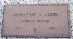
Ernestine A Wilson Green
| Birth | : | 1 Aug 1923 Milford, Geary County, Kansas, USA |
| Death | : | 1 Mar 2001 Wichita, Sedgwick County, Kansas, USA |
| Burial | : | Milford Cemetery, Milford, Geary County, USA |
| Coordinate | : | 39.1828003, -96.9047012 |
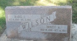
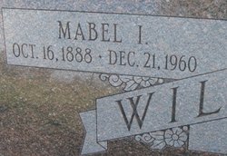
| Description | : | Ernestine died March 1, 2001 in Wichita. She was born August 1, 1923 at Milford, the daughter of Ernest and Mabel Cleveland Wilson. On May 16, 1941 she married Wayne Green; he preceded her in death on April 20, 1980. She was preceded in death by one daughter, Gwynetha Green on October 10, 1969. (JC Daily Union Mar 2, 2001) --Submitted by Lisa Osbourn |
frequently asked questions (FAQ):
-
Where is Ernestine A Wilson Green's memorial?
Ernestine A Wilson Green's memorial is located at: Milford Cemetery, Milford, Geary County, USA.
-
When did Ernestine A Wilson Green death?
Ernestine A Wilson Green death on 1 Mar 2001 in Wichita, Sedgwick County, Kansas, USA
-
Where are the coordinates of the Ernestine A Wilson Green's memorial?
Latitude: 39.1828003
Longitude: -96.9047012
Family Members:
Parent
Spouse
Siblings
Children
Flowers:
Nearby Cemetories:
1. Milford Cemetery
Milford, Geary County, USA
Coordinate: 39.1828003, -96.9047012
2. Barry Cemetery
Milford, Geary County, USA
Coordinate: 39.1889000, -96.9218979
3. Branscom Cemetery
Milford, Geary County, USA
Coordinate: 39.1627998, -96.8942032
4. Shanks Cemetery
Riley, Riley County, USA
Coordinate: 39.1750000, -96.8413400
5. Vinton Cemetery
Geary County, USA
Coordinate: 39.1375008, -96.8399963
6. Timber Creek Cemetery
Wakefield, Clay County, USA
Coordinate: 39.2182999, -96.9805984
7. Madura Cemetery
Wakefield, Clay County, USA
Coordinate: 39.1842003, -97.0117035
8. Alida Cemetery
Geary County, USA
Coordinate: 39.1030998, -96.9618988
9. Highland Cemetery
Wakefield, Clay County, USA
Coordinate: 39.2190247, -97.0133667
10. Saint Johns Cemetery
Geary County, USA
Coordinate: 39.0741997, -96.9610977
11. Gatesville Cemetery
Wakefield, Clay County, USA
Coordinate: 39.2721460, -97.0041380
12. Alida Zion Evangelical Cemetery
Upland, Dickinson County, USA
Coordinate: 39.0750008, -96.9721985
13. Bala Cemetery
Bala, Riley County, USA
Coordinate: 39.3053017, -96.9341965
14. Riley Cemetery
Riley, Riley County, USA
Coordinate: 39.2882996, -96.8125000
15. Liberty Cemetery
Upland, Dickinson County, USA
Coordinate: 39.0896988, -97.0278015
16. Saint John's Episcopal Cemetery
Clay County, USA
Coordinate: 39.2193985, -97.0744019
17. Fort Riley Post Cemetery
Fort Riley, Geary County, USA
Coordinate: 39.0638500, -96.7934900
18. Cavalry Parade Field
Fort Riley, Geary County, USA
Coordinate: 39.0638800, -96.7839200
19. Saint Patricks Cemetery
Ogden, Riley County, USA
Coordinate: 39.1236000, -96.7208023
20. Uniondale Cemetery
Wakefield, Clay County, USA
Coordinate: 39.2382800, -97.0918400
21. Gilbert Cemetery
Clay County, USA
Coordinate: 39.2853012, -97.0625000
22. Good Hope Cemetery
Chapman, Dickinson County, USA
Coordinate: 39.0388985, -96.9991989
23. Ogden Cemetery
Ogden, Riley County, USA
Coordinate: 39.1225014, -96.7106018
24. Fairview Cemetery
Riley, Riley County, USA
Coordinate: 39.3351300, -96.8291700


